Riau Islands
| Riau Islands Kepulauan Riau | |||||||
|---|---|---|---|---|---|---|---|
| Province | |||||||
| Other transcription(s) | |||||||
| • Jawi | كڤولاوان رياو | ||||||
| • Chinese | 廖内群岛 | ||||||
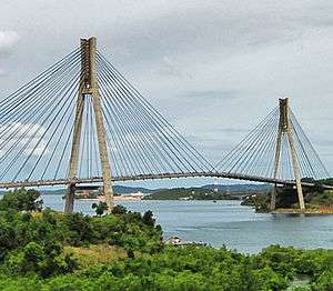
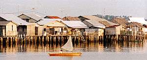
From top, left to right: Barelang Bridge, Bungalows at Loola resort, Trikora beach Bintan, Batam centre and Orang laut village of Senggarang, near Tanjung Pinang | |||||||
| |||||||
|
Motto: Berpancang Amanah Bersauh Marwah (Malay) (Staked by Trust, Anchored by Dignity) | |||||||
 Location of Riau Islands in Indonesia | |||||||
| Coordinates: 3°56′N 108°09′E / 3.933°N 108.150°ECoordinates: 3°56′N 108°09′E / 3.933°N 108.150°E | |||||||
| Country |
| ||||||
| Established | September 24, 2002 | ||||||
| Capital |
| ||||||
| Government | |||||||
| • Body | Riau Islands Regional Government | ||||||
| • Governor | Nurdin Basirun (acting) (Nasdem Party) | ||||||
| • Vice-governor | Vacant | ||||||
| Area | |||||||
| • Total | 10,595.41 km2 (4,090.91 sq mi) | ||||||
| Area rank | 31st | ||||||
| Elevation | 2-5 m (−14 ft) | ||||||
| Highest elevation | 1,165 m (3,822 ft) | ||||||
| Lowest elevation | 0 m (0 ft) | ||||||
| Population (2015)[1] | |||||||
| • Total | 1,973,403 | ||||||
| • Rank | 27th | ||||||
| • Density | 190/km2 (480/sq mi) | ||||||
| • Density rank | 10th | ||||||
| Demonym(s) |
Riau Islander Warga Kepulauan Riau (id) Kaum Kepulauan Riau (ms) | ||||||
| Demographics | |||||||
| • Ethnic groups |
Malays (35.6%) Javanese (18.2%) Chinese (14.3%) Minangkabau (9.3%) Batak (8.1%) Buginese (2.2%) Banjarese (0.7%)[2] | ||||||
| • Religion |
Islam (70.34%) Protestantism (11.17%) Buddhist(9.09%) Hinduism (4.65%) Roman Catholicism (2.28%) Confucianism (0.2%) | ||||||
| • Languages |
Indonesian (official) Malay (regional) Other languages: Javanese, Minangkabau, Batak, Buginese, Banjarese, Riau Hokkien, Hakka, Teochew, Yue, Mandarin, Tamil | ||||||
| Time zone | Indonesia Western Time (UTC+7) | ||||||
| Postcodes | 29xxx | ||||||
| Area codes | (62)77x | ||||||
| ISO 3166 code | ID-KR | ||||||
| Vehicle sign | BP | ||||||
| GRP per capita | US$ 8,036.09 | ||||||
| GRP rank | 5th | ||||||
| HDI |
| ||||||
| HDI rank | 4th (2015) | ||||||
| Largest city by area | Batam - 770.27 square kilometres (297.40 sq mi) | ||||||
| Largest city by population | Batam - (1,188,985 - 2015) | ||||||
| Largest regency by area | Karimun Regency - 2,873.20 square kilometres (1,109.35 sq mi) | ||||||
| Largest regency by population | Karimun Regency - (225,298 - 2015) | ||||||
| Website | Government official site | ||||||


Riau Islands Province (Indonesian; Provinsi Kepulauan Riau, acronym; Kepri, Jawi: كڤولاوان رياو, Chinese: 廖内群岛; pinyin: Liào nèi qúndǎo), is a province of Indonesia. It comprises the principal group of the Riau Archipelago along with other island groups to the south, east and northeast. In Indonesian, Riau Islands and Riau Archipelago are synonymous and are distinguished by the word for province, "Provinsi".
Originally part of the Riau province, the Riau Islands were split off as a separate province in September 2002.
Geography and population
The island of Batam, which lies within the central core group of islands (the Riau Archipelago), contains a majority of the province's population. Since becoming part of a Demilitarized Zone with Singapore in 2006, it has experienced high population growth rates. Other highly populated islands in the Riau Archipelago include Bintan and Karimun, while the archipelago also includes islands such as Bulan and Kundur. There are around 3,200 islands in the province, which has its capital at Tanjung Pinang in the south of Bintan Island. The province includes the Lingga Islands to the south of the main Riau Archipelago, while to the northeast lies the Tudjuh Archipelago, between Borneo and mainland Malaysia; the Tudjuh Archipelago consists of four distinct groups — the Anambas Islands, Natuna Islands, Tambelan islands and Badas Islands — which were attached to the new province, though not geographically part of the Riau Archipelago. The 2015 census count was 1,968,313, less than estimated but nevertheless the 2nd fastest growing province in the nation.
Language
The language of the Riau Islands is known as Riau Malay. The Riau Islands are considered the birthplace of the modern Malay language, though it was the classical Malaccan Malay of the Johor court rather than Riau Malay that formed the basis of the standard language.[3] Besides proper Riau Malay, there are several distinct varieties of Malay spoken in the province as well, especially those in Anambas Islands and Natuna Islands where they speak a form of Malay much more closely related to varieties of Malay in the eastern coast of Peninsular Malaysia like in Terengganu and Pahang as well as varieties spoken in Sarawak.
History
From Srivijayan times until the 16th century, Riau was a natural part of greater Malay kingdoms or sultanates, in the heart of what is often called the Malay World, which stretched from eastern Sumatra to Borneo. The Malay-related Orang Laut tribes inhabited the islands and formed the backbone of most Malay kingdoms from Srivijaya to the Johor Sultanate for the control of trade routes going through the straits.
After the fall of Malacca in 1511, the Riau islands became the centre of political power of the mighty Sultanate of Johor or Johor-Riau, based on Bintan Island, and were for long considered the centre of Malay culture.[4]
But history changed the fate of Riau as a political, cultural or economic centre when European powers struggled to control the regional trade routes and took advantage of political weaknesses within the sultanate. Singapore island, that had been for centuries part of the same greater Malay kingdoms and sultanates, and under direct control of the Sultan of Johor, came under control of the British.
The creation of a European-controlled territory in the heart of the Johor-Riau natural boundaries broke the sultanate into two parts, destroying the cultural and political unity that had existed for centuries. The Anglo-Dutch Treaty of 1824 consolidated this separation, with the British controlling all territories north of the Singapore strait and the Dutch controlling territories from Riau to Java.
After the European powers withdrew from the region, the new independent governments had to reorganise and find balance after inheriting 100 years of colonial boundaries. Before finding their current status, the territories of Indonesia, Malaysia, Singapore, Brunei and Borneo struggled and even came into military conflict against each other, and the Riau islands once again found themselves in the middle of a regional struggle.
The strong cultural unity of the region with Riau in the heart of this region never returned, and the line drawn by the British in 1819 remained, dividing the area into three new countries in 1965: Singapore, the Malaysian federation in the north, and Indonesia in the south.
Some level of unity returned in the Riau region for the first time after 150 years, with the creation of the Sijori Growth Triangle in 1989. But while bringing back some economical wealth to Riau, the Sijori Growth Triangle somewhat further broke the cultural unity within the islands. With Batam island receiving most of the industrial investments and dramatically developing into a regional industrial centre, it attracted hundreds of thousands of non-Malay Indonesian migrants, changing forever the demographic balance in the archipelago.
However, the upside of this demographic shift is that Batam is more multi-cultural and civilized than how it was before, with a greater potential for better economic and educational development in future. Batam has become an industrial island with a booming tourism sector. Previously under the native population's administration, it was nothing more than an oversized fishing & farming village with a high level of illiteracy and economic stagnation.
There have been various attempts at both independence and autonomy for this part of Indonesia since the founding of Indonesia in 1945.[5]
Administrative divisions
This province is divided into five regencies (kabupaten) and two cities (kotamadya), listed below with their (provisional) populations at the 2010 Census:
| Name | Area (km2) | Population Census 2000 | Population Census 2010 | Population Est 2014 | Capital | Notes |
|---|---|---|---|---|---|---|
| Batam City | 960.25 | 455,103 | 944,285 | 1,142,646 | Batam | includes Bulan, Galang and Rempang islands, as well as all of Batam Island |
| Tanjung Pinang City | 144.56 | 142,929 | 187,359 | 226,716 | Tanjung Pinang | on Bintan Island |
| Anambas Islands Regency (Kepulauan Anambas) | 590.14 | 28,510 | 37,411 | 45,270 | Tarempa | |
| Bintan Regency | 1,318.21 | 110,068 | 142,300 | 172,192 | Bandar Seri Bentan | |
| Karimun Regency | 912.75 | 171,405 | 212,561 | 257,212 | Tanjung Balai | including Karimun and Kundur Islands |
| Lingga Regency | 2,266.77 | 79,451 | 86,244 | 104,361 | Daik | covering the Lingga Islands |
| Natuna Regency | 2,009.04 | 52,741 | 69,003 | 83,498 | Ranai |
Hubs
As the closest neighbour of Singapore and to realise that Soekarno–Hatta International Airport is fully utilised, Lion Air is developing hangars in Batam Island and Garuda Indonesia is developing a new airport, with runway and maintenance facilities so as to make a new air hub in Bintan Island.[6]
References
- ↑ "Provinsi Kepulauan Riau Dalam Angka 2016" (PDF) (in Indonesian). Retrieved 2016-09-24.
- ↑ Kepulauan Riau, Keberagaman Identitas dalam Kesatuan Kultur. ePaper Interaktif Kompas. 6 February 2009.
- ↑ Sneddon 2003, "The Indonesian Language: Its History and Role in Modern Society", p. 70
- ↑ The Riau Islands and economic cooperation in the Singapore Indonesian border zone Karen Peachey, Martin Perry, Carl Grundy-Warr, Clive H Schofield, University of Durham. International Boundaries Research Unit, illustrated, IBRU, 1997, ISBN 1-897643-27-6, ISBN 978-1-897643-27-3, pg. 6–10
- ↑ paper on the Riau Independence movement
- ↑ "Garuda Indonesia Create New Hub in Bintan Island". 11 February 2014.
External links
-
 Riau Islands travel guide from Wikivoyage
 - http://www.navegar-es-preciso.com/news/islas-anambas/
- http://www.navegar-es-preciso.com/news/archipielago-de-tambelan/
Regencies and cities of Riau Islands Province | ||
|---|---|---|
Capital: Tanjung Pinang | ||
| Regencies | ||
| Cities | ||
Main islands of Riau Islands Province | ||
|---|---|---|
| Riau Archipelago |
| |
| Natuna Islands |
| |
| Anambas Islands |
| |
| Lingga Islands | ||
Template:Indonesia