Rhode Island Route 2
| ||||
|---|---|---|---|---|
 | ||||
| Route information | ||||
| Maintained by RIDOT | ||||
| Length: | 33.6 mi[1] (54.1 km) | |||
| Existed: | ca 1934 – present | |||
| Major junctions | ||||
| South end: |
| |||
|
| ||||
| North end: |
| |||
| Location | ||||
| Counties: | Washington, Kent, Providence | |||
| Highway system | ||||
| ||||

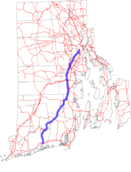
Route 2 is a state highway in the U.S. state of Rhode Island. It runs approximately 36 miles (58 km) from US 1 in Charlestown to US 1 in Providence.
Route description
Route 2 starts at US 1 in Charlestown, which is also the southern terminus of Route 112. Route 2 and Route 112 continue north, and Route 2 splits off to the northeast before intersecting with Route 138. Continuing in a northeast direction, Route 2 has a short concurrency with Route 102 in North Kingstown. It then turns to the north and parallels Route 4 until reaching I-95. Route 2 passes the eastern terminus of Route 3 before reaching an interchange with I-295. It continues through downtown Cranston and has interchanges with Route 37 and Route 10 before reaching its northern terminus at US 1 slightly inside the city line of Providence. Route 2 is a heavily traveled highway in Cranston and Warwick as it is a major commercial corridor.
History
By 1939, Route 2 was paved with concrete between the split from Route 112 and Route 12. It had short overlaps with Route 117 and Route 5, both of which have been eliminated with interchanges.
For a brief time during the construction of the Route 10 freeway, Route 2 left Reservoir Avenue in Cranston and turned north onto the current Route 10 freeway, ending at the Olneyville exit.
Major intersections
| County | Location | mi[1] | km | Destinations | Notes |
|---|---|---|---|---|---|
| Washington | Charlestown | 0.0 | 0.0 | South end of concurrency with Route 112 | |
| 3.0 | 4.8 | North end of concurrency with Route 112 | |||
| South Kingstown | 9.6 | 15.4 | |||
| North Kingstown | 16.4 | 26.4 | South end of concurrency with Route 102 | ||
| 17.1 | 27.5 | Exit 5 on Route 4 | |||
| 17.4 | 28.0 | North end of concurrency with Route 102 | |||
| Kent | East Greenwich | 19.7 | 31.7 | Exit 6 on Route 4 | |
| 20.6 | 33.2 | West end of Route 402 | |||
| 23.1 | 37.2 | West end of Route 401 | |||
| Warwick | 23.3 | 37.5 | Exit 8 on I-95 | ||
| 24.6 | 39.6 | North end of Route 3 | |||
| 25.4 | 40.9 | Interchange | |||
| 26.4 | 42.5 | ||||
| 27.1 | 43.6 | West end of Route 113 | |||
| 27.5 | 44.3 | Same directional access only (e.g. north-to-north), exit 2 on I-295 | |||
| 27.8 | 44.7 | Natick Road – Warwick Mall | |||
| Providence | Cranston | 28.4 | 45.7 | Interchange, no northbound exit, north end of Route 33 | |
| 28.6 | 46.0 | Interchange | |||
| 29.2 | 47.0 | Brayton Avenue | Interchange, southbound exit and entrance | ||
| 29.9 | 48.1 | Exit 2 on Route 37 | |||
| 30.3 | 48.8 | Sockanosset Cross Road / Dean Parkway | |||
| 30.8 | 49.6 | Garden City Center | Interchange, southbound exit and northbound entrance | ||
| 32.2 | 51.8 | ||||
| Providence | 32.7 | 52.6 | Interchange | ||
| 33.6 | 54.1 | Northern terminus | |||
1.000 mi = 1.609 km; 1.000 km = 0.621 mi
| |||||
Gallery
-

Route 2's concurrency with Route 102 in North Kingstown
-

Route 2 (Bald Hill Road) at Tollgate Road, facing north towards Cranston
References
- 1 2 Google (23 December 2013). "Route 2" (Map). Google Maps. Google. Retrieved 23 December 2013.