Rennerdale, Pennsylvania
| Rennerdale, Pennsylvania | |
|---|---|
| Census-designated place | |
|
Walker-Ewing Log House, built around 1790 | |
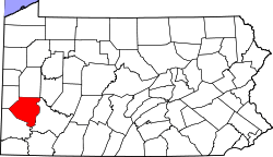
 Location in Allegheny County and state of Pennsylvania | |
| Coordinates: 40°23′52″N 80°8′26″W / 40.39778°N 80.14056°WCoordinates: 40°23′52″N 80°8′26″W / 40.39778°N 80.14056°W | |
| Country | United States |
| State | Pennsylvania |
| County | Allegheny |
| Township | Collier |
| Area | |
| • Total | 0.8 sq mi (2.0 km2) |
| • Land | 0.8 sq mi (2.0 km2) |
| • Water | 0 sq mi (0 km2) |
| Population (2010) | |
| • Total | 1,150 |
| • Density | 1,500/sq mi (580/km2) |
| Time zone | Eastern (EST) (UTC-5) |
| • Summer (DST) | EDT (UTC-4) |

Rennerdale is an unincorporated community and census-designated place in Collier Township, Allegheny County, Pennsylvania, United States, about 9 miles (14 km) southwest of Pittsburgh.[1] As of the 2010 census it had a population of 1,150.[2]
Geography
Set in the Allegheny Plateau, Rennerdale is built on a southward-facing hill that slopes from 1,032 feet (315 m) down to 882 feet (269 m), where it approaches Robinson's Run, a creek that flows eastward toward Chartiers Creek and the Ohio River.[1] The surrounding area was mined for coal from as early as 1870,[3] but the only currently active extraction enterprise is a quarry east of the town.
History
An early settler of this region was James Ewing, who arrived in 1770 and built a grist mill on Robinson's Run. Gabriel Walker and Isaac Walker, Scots-Irish brothers from Lancaster County, Pennsylvania, arrived in 1772. Gabriel Walker's household was raided by Indians in 1782.[3] Walker's Mills, the village east of Rennerdale, is named for Isaac Walker.[3] Between 1760 and 1790, Gabriel Walker built a log cabin about 2 miles (3 km) northwest of present-day Rennerdale; today known as the Walker-Ewing Log House, the structure still stands. In 1976, it was placed on the National Register of Historic Places.[4] Many Walkers have continued to live in the area up to the present day.
An 1876 atlas of Pittsburgh shows only these families residing on the land where Rennerdale is now located: Mrs. J. Maloney, James Hayes, J.E. Walker, E. Walker and G. Walker.[5]
Rennerdale's origins as a town are connected to the railroad. A railway that followed Robinson's Run was known as the Panhandle Route, because it crossed the Northern Panhandle of West Virginia. Connecting Pittsburgh with Cincinnati, Ohio, the railway was operated by the Pittsburgh, Cincinnati, Chicago and St. Louis Railroad (PCC&StL) and the Pittsburgh, Cincinnati and St. Louis Railroad. John W. Renner (b. January 1, 1845 in Petersburg, Pennsylvania - d. after 1915) was a comptroller for the latter company and for the Pennsylvania Railroad. In 1895, 60 acres on the PCC&StL line near Pittsburgh were purchased, and employees of the railroad's Lines West Accounting Department founded the town, which was named Rennerdale in honor of the comptroller.[6][7][8]
The 1910 census does not list Rennerdale as part of Collier Township, but 72 persons are counted on Sunnyside Avenue. Of the 21 heads of households, 11 were clerks in the railroad.[9]
The 1920 census enumerated 319 persons specifically in Rennerdale. Many heads of households were clerks in the railroad office; the others were either railway workers, miners or laborers. The following streets were extant: Sunnyside Avenue, Home Avenue, Linden Avenue, Maple Avenue and State Street (probably Noblestown Road).[10] One of these clerks,[10] William Kerr, was instrumental in establishing national Flag Day.[11][12]
Description
Rennerdale has some 320 single-family homes, many built between 1920 and 1960, with the newest built in 2005, and the oldest built in the 1840s.[13] Most homes sit on lots larger than half an acre, many with full-grown trees.[1][13]
The town has one business, the Rennerdale Corner Store, at 148 Noblestown Road. The Corner Store sells groceries and serves sandwiches and pizza.
Rennerdale's sole house of worship, Rennerdale United Presbyterian Church, is located at 151 Noblestown Road.[13] In addition to services, the church hosts community meetings, such as the monthly meeting of the Pittsburgh chapter of the National Railway Historical Society.
The Rennerdale Volunteer Fire Department, located at 30 Suburban Avenue,[13] provides emergency and firefighting services. It also sponsors an annual Halloween parade. Next to the fire station is a small spring-fed pond, where there is some recreational fishing (with a traditional catch and release policy). When the pond freezes over in winter, the townspeople use it for skating and ice hockey.
On the eastern end of town, Webb Field has two baseball fields (Little Webb and Big Webb) and a pavilion for community events. (Webb Field is named after Edward N. Webb, one of the original founders of Rennerdale Little League. The field was dedicated in 1967).
Rennerdale belongs to the Chartiers Valley School District, which includes Chartiers Valley Primary School, Middle School, Intermediate School and High School.
As an unincorporated community, Rennerdale has no mayor or police force.
Environs of Rennerdale
Less than a mile northwest of Rennerdale is Settler's Cabin Park, a 1,589-acre (6.43 km2) Allegheny County park, which includes the Walker-Ewing Log House, a wave pool, a diving pool, tennis courts, groves, shelters and trails.[14]
Immediately south of Rennerdale, the Panhandle Trail is a hike/bike rail trail that follows the bed of the old Panhandle railroad. The Panhandle Trail currently runs 29 miles (47 km) from Walker's Mills, Collier Township, to just outside Weirton, West Virginia. It connects with the Montour Trail between McDonald, Pennsylvania and the village of Primrose. An abandoned quarry alongside the trail serves as a backdrop for picnics and community parties. In the woods south of the trail is Fossils Cliff, notable for its plentiful fossils, mostly of fern leaves.
Atop the ridge south of Rennerdale is a private, Jack Nicklaus-designed golf course, The Club at Nevillewood, with a surrounding community.
Atop the western ridge is a former Project Nike missile site. Now known as the Charles E. Kelly Support Facility, it previously provided headquarters for the Army's 99th Regional Readiness Command (RRC). The facility was scheduled for closing by the 2005 Base Realignment and Closure Commission.[15] In 2008, the Kelly Center Local Redevelopment Authority (KCLRA) oversaw the development of a re-use plan for the base. This plan envisioned a small town center; recreation facilities, including ball fields, hiking paths and picnic areas; a small retail center; a small office/warehouse complex; a local emergency medical services center; and a public library. In April, 2009, the 99th RRC relocated to Fort Dix, New Jersey.[16]
See also
References
- 1 2 3 Google Earth
- ↑ "Race, Hispanic or Latino, Age, and Housing Occupancy: 2010 Census Redistricting Data (Public Law 94-171) Summary File (QT-PL), Rennerdale CDP, Pennsylvania". U.S. Census Bureau, American FactFinder 2. Retrieved September 30, 2011.
- 1 2 3 History of Allegheny county, Pennsylvania : including its early settlement and progress to the present time ; a description of its historic and interesting localities ; its cities, towns and villages; religious, educational, social and military history ; mining, manufacturing and commercial interests, improvements, resources, statistics, etc. ; also, biographies of many of its representative citizens. Prepared under the general supervision of Thomas Cushing. Originally Published: Chicago : A. Warner & Co., 1889. Original images and transcriptions available at Historic Pittsburgh
- ↑ National Register of Historic Places
- ↑ Plate 43 of the "1876 Atlas of the Cities of Pittsburgh, Allegheny and Adjoining Boroughs" at the Historic Pittsburgh map collection
- ↑ "The Pennsylvania Railroad System, Information for Employes and the Public, Philadelphia, Pittsburgh, February 27, 1915, page 3.
- ↑ “Railway World,” Philadelphia, September 3, 1898, page 978.
- ↑ Collier Township, Allegheny County, Pennsylvania. "Collier Township, Rennerdale". Retrieved 2014-04-02.
- ↑ 1910 United States Federal Census, PA, Allegheny Co, Collier Twp, District 43, 2A Ancestry.com
- 1 2 1920 United States Federal Census, PA, Allegheny Co, Collier Twp, District 66, 5A to 8B Ancestry.com
- ↑ Pennsylvania General Assembly - yearly resolutions include Senate Resolution No. 316, Session of 2006; House Resolution No. 790, Session of 2006; House Resolution No. 592, Session of 2002.
- ↑ William T. Kerr Historical Marker - reads "Known as 'The Father of Flag Day,' he founded the American Flag Day Association and served as its president for Fifty years. President Truman signed the Act of Congress that officially designated June 14 as Flag Day, with Kerr at his side, on August 3, 1949. Kerr lived here in Rennersdale, 1911-1928.
- 1 2 3 4 Allegheny County Real Estate Web Site
- ↑ Allegheny County Parks Department
- ↑ 2005 BRAC Commission Final Report, pgs 74-75
- ↑ Fort Dix "the Post", April 24, 2009
| Counties | 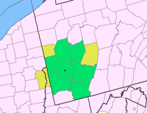 Map of the Pittsburgh Tri-State with green counties in the metropolitan area and yellow counties in the combined area. | |
|---|---|---|
| Major cities | ||
| Cities and towns 15k-50k (in 2010) | ||
| Airports | ||
| Topics | ||
| ||