Reichenwalde
Reichenwalde is a municipality in the Oder-Spree district, in Brandenburg, Germany.
Demography
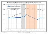
Development of population since 1875 within the current boundaries (Blue line: Population; Dotted line: Comparison to population development of Brandenburg state; Grey background: Time of Nazi rule; Red background: Time of communist rule)
Reichenwalde:
Population development within the current boundaries (2013)[2]
| Year |
Population |
|---|
| 1875 | 1 112 |
| 1890 | 1 099 |
| 1910 | 1 150 |
| 1925 | 1 160 |
| 1933 | 1 245 |
| 1939 | 1 193 |
| 1946 | 1 414 |
| 1950 | 1 453 |
| 1964 | 1 242 |
| 1971 | 1 187 |
|
|
| Year |
Population |
|---|
| 1981 | 1 065 |
| 1985 | 1 001 |
| 1989 | 984 |
| 1990 | 990 |
| 1991 | 968 |
| 1992 | 955 |
| 1993 | 971 |
| 1994 | 978 |
| 1995 | 987 |
| 1996 | 997 |
|
|
| Year |
Population |
|---|
| 1997 | 1 002 |
| 1998 | 1 061 |
| 1999 | 1 086 |
| 2000 | 1 087 |
| 2001 | 1 108 |
| 2002 | 1 118 |
| 2003 | 1 121 |
| 2004 | 1 109 |
| 2005 | 1 097 |
| 2006 | 1 095 |
|
|
| Year |
Population |
|---|
| 2007 | 1 106 |
| 2008 | 1 104 |
| 2009 | 1 119 |
| 2010 | 1 122 |
| 2011 | 1 122 |
| 2012 | 1 119 |
| 2013 | 1 113 |
|
|
References

