Red Mountain Pass (San Juan Mountains)
| Red Mountain Pass | |
|---|---|
|
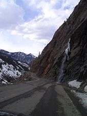
Lower gorge, Red Mountain Pass; view from HWY 550 near Ouray | |
| Elevation | 11,018 ft (3,358 m)[1] |
| Traversed by |
|
| Location | Ouray / San Juan counties, Colorado, U.S. |
| Range | San Juan Mountains |
| Coordinates | 37°53′56″N 107°42′43″W / 37.89889°N 107.71194°WCoordinates: 37°53′56″N 107°42′43″W / 37.89889°N 107.71194°W |


Red Mountain Pass elevation 11,018 ft (3,358 m) is a mountain pass in the San Juan Mountains of western Colorado in the United States.
The pass straddles a divide that separates Ouray and San Juan counties. The pass is named for the nearby Red Mountain on the northeast side of the pass. The name is derived from the iron oxide laden rock that forms their slopes.
The pass separates the Uncompahgre and Las Animas River watersheds, and also serves as a dividing point between the Uncompahgre and San Juan National Forests. The pass is traversed by the Million Dollar Highway, U.S. Highway 550 between Ouray and Silverton, which is part of the San Juan Skyway Scenic Byway.
The pass is known for being treacherous in the wintertime due to the steep 8% grade and switchbacks on the north side facing Ouray, though the entire road is paved. Avalanches are frequent, and can block the highway for some time. The lower part of the pass towards Ouray is blasted into near-vertical cliffs of quartzite hundreds of feet above Red Mountain Creek and the Uncompahgre River. This section of road is winding, narrow and has no shoulder.
Mining district
The Red Mountain Mining District lies from the divide northward to Ironton Park, halfway down towards Ouray. It was the site of an historic silver boom from 1882-1893, including the Yankee Girl, National Belle and Guston mines and the towns of Red Mountain and Ironton. Head frames of the old workings are still visible from the highway.[2] The Idarado Mine (Treasury Tunnel) continued until the 1970s, and reclamation of tailings is ongoing.
| Wikimedia Commons has media related to Red Mountain Pass. |
References
- ↑ "Red Mountain Pass". Geographic Names Information System. United States Geological Survey. Retrieved 2011-02-05.
- ↑ Smith, P. David, (2004) "Mountains of Silver; Life in Colorado's Red Mountain Mining District": Western Reflections Publishing Co.