Recklinghausen (district)
| Recklinghausen | |
|---|---|
| District | |
 | |
| Country |
|
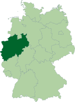
| State | North Rhine-Westphalia |
| Adm. region | Münster |
| Capital | Recklinghausen |
| Area | |
| • Total | 760.27 km2 (293.54 sq mi) |
| Population (31 December 2015)[1] | |
| • Total | 617,807 |
| • Density | 810/km2 (2,100/sq mi) |
| Time zone | CET (UTC+1) |
| • Summer (DST) | CEST (UTC+2) |
| Vehicle registration | RE, GLA |
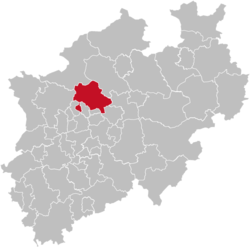
Recklinghausen (German pronunciation: [ʁɛklɪŋˈhaʊzən]) is a Kreis (district) in the centre of North Rhine-Westphalia, Germany. It is surrounded by the neighbouring districts of Borken, Coesfeld, Unna, Gelsenkirchen, Bottrop, and Wesel. The district administration is located in the city of the same name.
Apart from the Region Hannover, Kreis Recklingshausen is the largest non-city district in Germany by population.[2]
History
During medieval times, the area surrounding present-day Recklinghausen was known as Vest Recklinghausen, a territory which belonged to the Electorate of Cologne. From 1446 to 1576, this area was leased to the lordship of Gemen (now a part of the city Borken) and Schaumburg-Lippe. In 1811, the territory was added to the Grand Duchy of Berg, and in 1815 it became part of the Prussian Province of Westphalia.
The district was created in 1816. After several changes it obtained its present borders with the last reorganizations of 1975-76. It is also one of the oldest districts located in Germany.
Geography
The district Recklinghausen is located at the north of the Ruhr area with the urban parts of Ruhr area to the south and the rural Münsterland to the north. [3] The Lippe River flows through the district.
Coat of arms
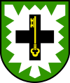 |
The coat of arms show a silver nettle leaf on green ground - the sign of the Herrlichkeit Lembeck, an Amt (subdivision) in the clerical state of Münster. The black cross is the sign of the Bishops of Cologne who owned a big part of the district's area, the Vest Recklinghausen. The key inside the cross symbolizes St. Peter, the patron of Cologne.[4] |
Cities
Partner districts
- Wodzisław County, Poland.
- Landstinget Sörmland, Sweden[5]
References
- ↑ "Amtliche Bevölkerungszahlen". Landesbetrieb Information und Technik NRW (in German). 18 July 2016.
- ↑ https://www.destatis.de/DE/ZahlenFakten/LaenderRegionen/Regionales/Gemeindeverzeichnis/Administrativ/Aktuell/04Kreise.html
- ↑ https://www.britannica.com/place/Recklinghausen
- ↑ https://heraldik-wiki.de/wiki/Wappen_der_deutschen_Stadt-_und_Landkreise
- ↑ http://www.kreis-re.de/Inhalte/Buergerservice/Zahlen_Daten_Fakten/_Partnerkreise.asp
External links
![]() Media related to Kreis Recklinghausen at Wikimedia Commons:
Media related to Kreis Recklinghausen at Wikimedia Commons:
- Official website (German)
- Official mapserver (German)
- Corpus juris of the county of Recklinghausen
Coordinates: 51°40′N 7°10′E / 51.67°N 7.17°E