Rangamati Hill District
| Rangamati Rangamattye | |
|---|---|
 | |
| Coordinates: 22°38′N 92°12′E / 22.633°N 92.200°ECoordinates: 22°38′N 92°12′E / 22.633°N 92.200°E | |
| Country |
|
| Division | Chittagong Division |
| District | Rangamati District |
| Government | |
| • Member of the Parliament from Rangamati Hill District | Ushatan Talukder (Chakma) |
| • Deputy Commissioner(DC) & District Magistrate(DM) | Md. Shamsul Arefin |
| • Chakma Raja (Chakma Circle Chief) | Debashish Roy |
| • Pouroshava Mayor | Saiful Islam Vuttu |
| Area | |
| • Total | 6,116.11 km2 (2,361.44 sq mi) |
| • Land | 4,824.63 km2 (1,862.80 sq mi) |
| • Water | 1,291.5 km2 (498.7 sq mi) |
| Elevation[1] | 17 m (56 ft) |
| Population (2011 census) | |
| • Total | 595,979 |
| • Density | 97/km2 (250/sq mi) |
| Time zone | BST (UTC+6) |
| Postal Code | 4500 |
| Area code(s) | 0351 |
| Population & Area related info taken from রাঙ্গামাটি জেলা তথ্য বাতায়নে আপনাকে স্বাগতম [Welcome to the Rangamati district portal]. Deputy Commissioner Rangamati (in Bangla). Archived from the original on 2013-01-17. | |
Rangamati (Bengali: রাঙামাটি Chakma:𑄢𑄋𑄟𑄖𑄨) is a district in south-eastern Bangladesh. It is a part of the Chittagong Division[2] and the town of Rangamati serves as the headquarters of the district. Area-wise, Rangamati is the largest district of the country.
History
Rangamati was a contesting ground for the kings of Tripura and Arakan. This region came under the Mughal Empire after the Muslim invasion in 1566.[3] In 1737 Sher Mosta Khan, a tribal leader, took refuge with the Mughals. After this the Chakma settlement began along with various other settlements of varying ethnicity.[3] From 1760 to 1761, this land was leased to the East India Company.[3]
Demography

The total population is 5,08,182 according to 2005 census of which tribal 52% and non-tribal 48%. The number of males is 2,87,060 and the females are 2,38,043 (Census 2001). The density of population is 83 per square kilometer (Census 2001). The number of household is 1,03,974 having the household size 4.8 (Census 2001). The total population is divided into Bangalees and eleven tribes (ethnic minorities): Chakma, Marma, Tanchangya, Tripura, Pankua, Lushai, Khiang, Murang, Rakhain, Chak, Bowm,Khumi.[4]
Tribal population : (as per census of 2005 ): Chakma-1,86,395, Marma-44,727, Tanchanga-18,607, Tripura-6,697, Pankho- 2,118, Bowm-1,053, khyang- 791, Lusai- 217, Chak- 177, Rakhain-70, Khumi- 50, Gurkha-03, Etc.-174[4]
As per 1991 census, the religious break up of the population of the district were: Buddhist 53.83%,Muslim 39.28%, Hindu 5.62% and Christian 1.12%. Religious institutions Pagoda 1230, Mosque 1059, Temple 65, Church 16. Genderwise, male constituted 53.59% and female constituted 46.41% of the population.[4]
Geography
Rangamati is located in the Chittagong Division. It is bordered by the Tripura state of India to the north, Bandarban District to the south, Mizoram State of India and Chin State of Myanmar to the east, and Khagrachari and Chittagong Districts to the west.
The area of the district is 6116 km2 of which 1292 km2 is riverine and 4825 km2 is under forest vegetation.
Administration
- For the District Administration, see District Administration, Rangamati.
District Administration is the apex office of a district at the present context of administrative setting of Bangladesh. It is the management of affairs within a district, which is the basic territorial unit of administration in the country. It is at this level that the common man comes into direct contact with the administration. The district falls under the charge of a district officer, called either Deputy Commissioner or District Collector or District Magistrate. This officer acts as the representative of the central government at this level. Like other district administrations of the country, District Administration Rangamati, widely known as the Office of the deputy commissioner is the representative of the cabinet in the Rangamati Hill District.
- Deputy Commissioner (DC) & District Magistrate (DM): Md.Shamsul Arefin
- Chairman of Zila Porishod: Brisketu Chakma
- Chakma King: Debashish Roy[5]
Education
There are 291 government primary schools, 120 non-government primary schools, 22 junior schools, 6 government high schools, 45 non-government high schools, 2 government colleges, 13 non-government colleges, 61 madrasa, 7 technical schools,1 medical college and 1 science and technology university located throughout the district.
Subdivisions
The district of Rangamati consists of 10 upazilas, 1 municipality (9 wards and 35 mahallas), 50 union parishads, 162 mouzas and 1347 villages.
Upazilas and unions
- Rangamati Sadar Upazila
- Balukhali
- Bandukbhanga
- Jibtoli
- Kutukchari
- Mogban
- Shapchari
- Belaichhari Upazila
- Bilaichari Sadar
- Farua
- Kengrachari
- Bagaichhari Upazila
- Baghaichari
- Bangaltali
- Khedarmara
- Marishya
- Rupakari
- Sajek
- Sarbotali
- Barkal Upazila
- Aimachara
- Baraharina
- Barkal
- Bhushonchara
- Subalong
- Juraichhari Upazila
- Bonjugichara
- Dumdumia
- Jurachari
- Moydong
- Rajasthali Upazila
- Bangalhalia
- Gainda
- Ghilachari
- Kaptai Upazila
- Chandraghona
- Chithmorong
- Kaptai
- Raikhali
- Wagga
- Langadu Upazila
- Adarakchara
- Bhasonna Adam
- Boghachatar
- Gulshyakhali
- Kalapagazya
- Langadu
- Myanimukh
- Naniarchar Upazila
- Burighat
- Ghilachari
- Naniarchar
- Sabekkhong
- Kaukhali Upazila
- Betbunia
- Fatikchari
- Ghagra
- Kolompati
Economy

The economy of Rangamati is hugely dependent on agriculture with a total of 41.94% of the population employed there. Other occupational percentages are: agricultural labourer 12.06%, wage labourer 4.95%, commerce 8.22%, service 13.04%, fishing 2.02%, industry 4.57%, forestry 3.2% and others 10%. A grand total of 12275 hectares of land is used for cultivation,producing food and non food crops such as rice, potato, corn, mustard seed, cotton and jute among others. Fruits such as mango, jackfruit, banana, pineapple, litchi, black berry are also grown in Rangmati.
Notable cottage industries of Rangamati are weaving, blacksmithing and wood work.Weaving is particularly famous for their woolen and jute rugs and hand loom cloth. Major industries include Chandraghona paper and rayon mill, Plywood Factory, Ghagra Textile and a Satellite Station at Betbunia amongst many others, producing and exporting goods.[3]
Tourism
Kaptai lake
Kaptai Lake is a man made lake in south-eastern Bangladesh. It is located in the Kaptai Upazila under Rangamati District of Chittagong Division. The lake was created as a result of building the Kaptai Dam on the Karnaphuli River, as part of the Karnaphuli Hydro-electric project. The Kaptai Lake's average depth is 100 feet (30 m) and maximum depth is 490 feet (150 m). This lake was developed by inundating valleys and plain lands between lots of hills. This made a beautiful scenario while forested mountains and highland climb from within the water.
Hanging Bridge
In Bengali the name of the Hanging Bridge is Jhulonto Bridge and this is also popular to its visitors. This hanging bridge is established on Kaptai Lake. This is the link way of Kaptai Lake. The total height of this bridge is 335 feet and is the landmark icon of Rangamati.[6]
Kaptai National Park
Kaptai National Park cascades between the Karnaphuly and Kaptai Mountain assortments. It was conventional in 1999 and its area is 5,464.78 hectares (13,503.8 acres). Prior to announcement of the national park it was Sitapahar Reserve. It is about 57 kilometer from Chittagong city. In this park one can find plenty of old trees which were planted in 1873. In Kaptai National Park, there is various wildlife such as deer, jungle cat, elephant, monkey, etc. Many species of birds may also be of interest to tourists and bird lovers. Kaptai National Park is a safe and sanctuary for birds and other wildlife. The Forest Division founded picnic spots, and restaurants in this park.[7]
Shuvolong Waterfalls
Shuvolong a place in Barkol sub district, located about 25 kilometers (11 kilometers as the crow flies) away from Rangamati town. There are few waterfalls in Shuvolong area with the largest one falling from as high as 300 feet. In the past several years, this place has turned into a tourist destination due to beautiful waterfalls and the nearby market. Shuvolong is easily accessible by speed boat or motor boats from Rangamati.[8]
Sajek valley

Sajek is a union at Baghaichari Upazila in Rangamati districts. Basically it is name of a river which separates Bangladesh from India. The river flows into the Karnafuli River in the Chittagong Hill Tracts. Sajek Valley is situated in the North angle of Rangamati, near the Mizoram border boundary area. The valley is 1,800 ft high form sea level. Many small rivers flow through the hills among them Kachalon and Machalong are famous. The main ethnic minorities on the valley are Chakma, Marma, Tripura, Pankua, Lushai and Sagma. The place is known as hill queen for its natural beauty and roof of Rangamati. Marishsha is a name of a place near Sajek Valley. Most of the houses are made with bamboo. There is another place near Sajek, it is Kanlak, and it is famous for its orange orchard.
Most attractions of the spot are sun set, rain, morning, evening, and night and aborigine people. Tourists can buy indigenous peoples' products from haat (markets). Roads are like big snake spirals on the mountains. Most of the people are Buddhist and others are Christian here. A new road has been built up to the Ruilui Para by the guidance of Bangladesh army. On the way traveler need to take permission from the army camp. Bangladesh army is very helpful and cooperative. Now mobile network is available here. The valley is in Rangamati but tourists can reach there from Khagrachhari too. The route is Khagrachhori – Dighinala Bazaar – Bagaihat Bazaar – Machalong Haat – then Sajek. It is 62 km from Khagrachhari. Dighinala to Sajek is 40 km. Main transportation is Chander Gari.[9][10]
Notable person
- Raja Tridib Raay : former king of Chakma community, father of present king Debashish Raay, and lifetime federal minister and former ambassador of Pakistan to Argentina and United Nations[11][12]
- Member of tenth Jatiyo Sangshad: Usatun Talukder[13]
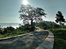
Gallery
 A resort at Sajek union, Rangamati
 Statue of sitting Buddha, Rangamati
 Shubhalang waterfall
 The Hanging Bridge
 Rajban Vihara (Buddhist Monastery)
 Lake surrounded by hills during winter
 Sun Rays Through The Clouds
 Clouds and hills Beside Rangamati Lake
 Fishing boat of the Rangamati locals
 Local People using boats for transportation
 Kaptai Lake view
See also
References
| Wikimedia Commons has media related to Rangamati District. |
- ↑ "Rangamati, Bangladesh Page". Global Gazetteer. Falling Rain.
- ↑ Atikur Rahman (2012). "Rangamati District". In Sirajul Islam and Ahmed A. Jamal. Banglapedia: National Encyclopedia of Bangladesh (Second ed.). Asiatic Society of Bangladesh.
- 1 2 3 4 "Rangamati Sadar Upazila". banglapedia.org.
- 1 2 3 রাঙ্গামাটি জেলা তথ্য বাতায়নে আপনাকে স্বাগতম [Welcome to the Rangamati district portal]. Deputy Commissioner Rangamati (in Bangla). Archived from the original on 2013-01-17. Retrieved 2009-09-15.
- ↑ "Daily Jugantor". jugantor.us. Archived from the original on 2012-12-28.
- ↑ "Go for Hanging Bridge of Rangamati Bangladesh which Looks Nice". news24ca.com.
- ↑ Tourism in Rangamati, Rajban Bihar Pagoda, Kaptai National Park, Hanging Bridge, DC Bungalow Area, http://touristbd.com/tourism-in-rangamati-rajban-bihar-pagoda-kaptai-national-park-hanging-bridge-dc-bungalow-area/
- ↑ "Visit Rangamati - Rangamati Tourist Information". jinghuabanglatours.com.
- ↑ "Khagrachori - Land of Stories". Visit Bangladesh.
- ↑ Bidesh Kumar. "Travel : Sajek Valley Tourist Spot in Rangamati". bdtravelguides.com.
- ↑ "Daily Jugantor". jugantor.us.
- ↑ A Reporter. "Raja Tridiv Roy dies". dawn.com.
- ↑ List of 10th Parliament Members
| Barisal Division | 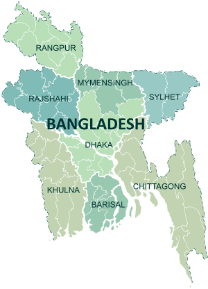 | |
|---|---|---|
| Chittagong Division | ||
| Dhaka Division | ||
| Khulna Division | ||
| Mymensingh Division | ||
| Rajshahi Division | ||
| Rangpur Division | ||
| Sylhet Division | ||