Ranchi district
| Ranchi district राँची जिला | |
|---|---|
| District of Jharkhand | |
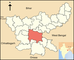 Location of Ranchi district in Jharkhand | |
| Country | India |
| State | Jharkhand |
| Administrative division | South Chotanagpur division |
| Headquarters | Ranchi |
| Government | |
| • Lok Sabha constituencies | 1. Ranchi, 2. Lohardaga (shared with Lohardaga district), 3. Khunti (shared with Khunti district) |
| • Assembly seats | 7 |
| Area | |
| • Total | 7,574 km2 (2,924 sq mi) |
| Population (2011) | |
| • Total | 2,912,022 |
| • Density | 380/km2 (1,000/sq mi) |
| Demographics | |
| • Literacy | 77.13 per cent[1] |
| • Sex ratio | 950 |
| Average annual precipitation | 1530 mm |
| Website | Official website |
Ranchi district (Hindi: राँची जिला) is one of the twenty-four districts of Jharkhand state in eastern India. Ranchi city, the capital of Jharkhand state is the district headquarters. It was established as a district in 1899.
As of 2011 it is the most populous district of Jharkhand (out of 24).[2]
Origin of name
The geographical area now comprising Ranchi district was formerly part of old Lohardaga district of the British India. In the year 1831-32, a part of old Lohardagga district was carved out and given the name of the Non-regulation South-West Frontier, and in 1899 the name of the district was changed to Ranchi district. Ranchi was the name of a type of bird (Ranchi chene-Mundari) seen in the local mountain temple.
History
The geographical area currently comprising the district of Ranchi was ruled by the Kshatriya rulers named hanimukut and was in the direct control of the kings of the epic period of the Mahabharata such as Jarasandh, the king of Rajgir. However Lord Krishna was believed to have a loose control over the territory.
Magadha Empire exercised indirect control over the territory, which lasted until the reign of the Ashoka. Kalinga rulers are believed to have ravaged the region during their expeditions to Rajgir and Pataliputra. Armies of Samudra Gupta passed through the region on their expedition to Deccan. After the decline of the Guptas, Phanimukut established the Kingdom of Chhotanagpur. The legendary Phanimukut, which literally means the crown of the cobra, was found by the side of a cobra (Nag in Hindi), and grew to be an industrious king, and founded the Nag Dynasty, which ruled Ranchi district and a larger part of Chota Nagpur Plateau as a sovereign king for almost next 1000 years.
With the expansion of the Mughal Empire, the sovereign status of the Nag Dynasty was technically affected, but they continued to rule and administer independently until the advent of the East India Company. During the period of the British Raj, adivasis and the local population of other ethnic backgrounds of Ranchi and other regions currently comprising the State of Jharkhand continued to oppose the subjugation by the British, and the region witnessed a number of uprisings and revolts.
Geography
Climate
| Ranchi | ||||||||||||||||||||||||||||||||||||||||||||||||||||||||||||
|---|---|---|---|---|---|---|---|---|---|---|---|---|---|---|---|---|---|---|---|---|---|---|---|---|---|---|---|---|---|---|---|---|---|---|---|---|---|---|---|---|---|---|---|---|---|---|---|---|---|---|---|---|---|---|---|---|---|---|---|---|
| Climate chart (explanation) | ||||||||||||||||||||||||||||||||||||||||||||||||||||||||||||
| ||||||||||||||||||||||||||||||||||||||||||||||||||||||||||||
| ||||||||||||||||||||||||||||||||||||||||||||||||||||||||||||
Ranchi has a humid subtropical climate. However, due to its position and the forests around the city, it is known for its pleasant climate. Its climate is the primary reason why Ranchi was once the summer capital of the undivided State of Bihar. Ranchi used to be a preferable hill station in the past. Temperature ranges from maximum 42 to 20 °C during summer, and from 25 to 0 °C during winter. December and January are the coolest months with temperature getting to freezing point in some places of the city. The annual rainfall is about 1430 mm (56.34 inches). From June to September the rainfall is about 1,100 mm. Ranchi is located at 23°21′N 85°20′E.[5] The total area covered by the Ranchi municipal area is 175.12 square kilometres and the average elevation of the city is 651 m above sea level.
Ranchi is located on the southern part of the Chota Nagpur plateau which forms the eastern edge of the Deccan plateau. Ranchi is referred to as the "City of Waterfalls", due to the presence of numerous large and small falls of around the close vicinity of the city. The most popular ones are Dassam Falls, Hundru Falls, Jonha Falls, Hirni Falls and Panchghagh Falls.
The Subarnarekha river and its tributaries constitute the local river system. Dams in Kanke, Rukka and Hatia have been built over these channels to cater to the water requirements of majority the population.
Ranchi has a hilly topography and its combination with dense tropical forests ensures that it enjoys a comparatively moderate climate compared to the rest of the state. Previously, it was accorded a 'hill station' status during the British rule. Rapid population growth and industrialization have caused considerable change in the weather pattern and rise in average temperatures. This has resulted in gradual loss of this "Hill Station" like status.
Economy
In 2006 the Indian government named Ranchi one of the country's 250 most backward districts (out of a total of 640).[3] It is one of the 23 districts in Jharkhand currently receiving funds from the Backward Regions Grant Fund Programme (BRGF).[3]
Divisions
Presently, Ranchi district is divided into 2 sub-divisions and 14 administrative blocks. On September 12, 2007, Khunti district was created by carving Khunti subdivision and its 6 blocks out of Ranchi district.
Ranchi sub-division is further divided into 11 blocks: Angara, Burmu, Bero, Chanho, Kanke, Lapung, Mandar, Namkum, Ormanjhi, Ratu and Silli. Bundu sub-division comprises 3 blocks: Bundu, Sonahatu and Tamar.
The district has 7 Vidhan Sabha constituencies, namely, Tamar, Silli, Khijri, Ranchi, Hatia, Kanke, and Mandar. Silli, Khijri, Ranchi, Hatia and Kanke are part of Ranchi Lok Sabha constituency.
Demographics
According to the 2011 census Ranchi district has a population of 2,912,022,[2] roughly equal to the nation of Jamaica[4] or the US state of Arkansas.[5] This gives it a ranking of 130th in India (out of a total of 640).[2] The district has a population density of 557 inhabitants per square kilometre (1,440/sq mi) .[2] Its population growth rate over the decade 2001-2011 was 23.9%.[2] Ranchi has a sex ratio of 950 females for every 1000 males,[2] and a literacy rate of 77.13%.[2]
Languages
Languages spoken here include Asuri, an Austroasiatic language spoken by approximately 17,000, partly in the north of Ranchi;[6] and Bijori, a Munda language distantly related to Khmer and Vietnamese, spoken by about 25,000.[7]
Education
Ranchi district boasts of many premier institutes in the field of higher education. This may be a reason that Ranchi has an average literacy rate of 77.13%(census 2011), higher than the national average of 74.04%: male literacy is 85.63%, and female literacy is 68.2%.
- Ranchi University, presently comrprising 35 constituent colleges and 29 affiliated colleges, was established in 1960. One of its constituent college, St. Xavier's College at Ranchi was established in 1944. Birla Institute of Technology at Mesra, Ranchi was established in 1955. Birsa Agricultural University at Ranchi was established in 1981.
- IIM Ranchi, the eighth Indian Institute of Management was established at Ranchi in 2010. It currently offers a two-year PGDM as its flagship program and has launched PFPEX recently for research work.
- National University of Study and Research in Law , Ranchi was established by a legislative act of the Government of Jharkhand as the fourteenth national law university of India . It offers graduate and post-graduate courses in law.
- Xavier Institute of Social Service (XISS), Ranchi started in the year of 1955 with an intention to educate young graduates in the field of social work and management programs. This department stated as the extension department of St Xavier’s college of Ranchi. In the year 1975, the department registered itself as a separate institute and established their new campus. The isolated campus of the Xavier Institute of Social Service is located in the Purulia Road, Ranchi. The institute offers graduate and post-graduate course in management studies.
- The Institute of Science & Management (ISM), formerly known as Indian Institute of Science & Management had, came into being in the year 1985 with an idea of catering to the long felt need of management education to the upcoming youth of the developing region of Chgotanagpur. It offers PGDM, Hotel Management & Catering Technology (HM&CT), B.A. International Hospitality Administration (B.A. – IHA) courses.
- National Institute of Foundry & Forge Technology (NIFFT) was set up by the Government of India in collaboration with UNDP-UNESCO to provide quality engineers and well trained specialists for running Manufacturing, Metallurgical, Foundry and Forge industries efficiently. Since its inception in 1966, NIFFT has earned a reputation of being a premier Institute for imparting technical education, training, research and development and consultancy in the fields of manufacturing, metallurgy & foundry and forge technologies. Apart from that with the expansion of the institute, the allied fields of information technology, Industrial Engineering and Environmental Engineering have also received impetus.
- Rajendra Institute of Medical Sciences (RIMS), a medical institute of Ranchi University in Ranchi, was established in 2002 by upgrading the then Rajendra Medical College Hospital (RMCH) which was established in 1960. The courses offered are MBBS, M.D., Mch Neurosurgery, BDS, Bsc nursing, Msc nursing, Paramedical and Physiotherapy.
- The Central Institute of Psychiatry, Ranchi is an institute offering higher level study in the domain of medical education. The institute also functions as a psychiatry unit for patients of all age groups. The Central Institute of Psychiatry, Ranchi is jointly administered by the Ministry of Health and Family Welfare and Directorate General of Health Services. The Central Institute of Psychiatry in Ranchi accepts psychiatric patients from all over India and also from Bhutan and Nepal. The institute offers Post-Graduate medical courses. The Central Institute of Psychiatry of Ranchi teaches higher level medical courses in Clinical Psychology, Psychiatry, Psychiatric Nursing and Psychiatric Social Work. Candidates may also pursue doctoral studies in Clinical Psychology. The British established this hospital on 17 May 1918 with the name of Ranchi European Lunatic Asylum. It may be worth noting that this Institute has been the most premier centre for mental health in the country and it has many firsts to its credit. For example, to mention only a few, the first Occupational Therapy Department in 1922, ECT in 1943, psychosurgery and neurosurgery in 1947, clinical psychology and Electroencephalography (EEG) departments in 1948, a full-fledged neuropathology section in 1952, the first use of Lithium in 1952 and chlorpromazine in 1953.
- The Central University of Jharkhand is a Central University, established by an act of Indian Parliament (Act no. 25 of 2009) in 2009. Like other Central Universities of India it is a teaching and research university. CUJ offers 50+ courses which includes a wide range of five year "Integrated Masters Programs" in more than 20 disciplines, 16 postgraduate programs and Ph.D in almost 20 disciplines. As of now the University is functional in its temporary 45-acre campus located at Brambe, Mandar.
Administration
Blocks/Mandals
Ranchi district consists of 06 Blocks.[8] The following are the list of the Blocks in Ranchi district:
References
- ↑ "Ranchi Census 2011 Highlights". Registrar General, India, Ministry of Home Affairs. Retrieved 2011-05-05.
- 1 2 3 4 5 6 7 "District Census 2011". Census2011.co.in. 2011. Retrieved 2011-09-30.
- 1 2 Ministry of Panchayati Raj (September 8, 2009). "A Note on the Backward Regions Grant Fund Programme" (PDF). National Institute of Rural Development. Retrieved September 27, 2011.
- ↑ US Directorate of Intelligence. "Country Comparison:Population". Retrieved 2011-10-01.
Jamaica 2,868,380 July 2011 est
- ↑ "2010 Resident Population Data". U. S. Census Bureau. Retrieved 2011-09-30.
Arkansas 2,915,918
- ↑ M. Paul Lewis, ed. (2009). "Asuri: A language of India". Ethnologue: Languages of the World (16th ed.). Dallas, Texas: SIL International. Retrieved 2011-09-28.
- ↑ M. Paul Lewis, ed. (2009). "Bijori: A language of India". Ethnologue: Languages of the World (16th ed.). Dallas, Texas: SIL International. Retrieved 2011-09-30.
- ↑ http://www.mapsofindia.com/maps/jharkhand/tehsil/ranchi.html
External links
| Wikimedia Commons has media related to Ranchi district. |
- Official government website
- List of places in Ranchi
 |
Chatra district Latehar district |
Hazaribagh district | Ramgarh district | |
| Lohardaga district | |
Purulia district, West Bengal | ||
| ||||
| | ||||
| Gumla district | Khunti district | Seraikela Kharsawan district |
Coordinates: 23°00′N 85°00′E / 23.000°N 85.000°E