Rail transport in Bangkok
Rail transport was introduced to Bangkok in 1893, and the national railway network was developed during the 20th century. Rapid transit in Bangkok includes several rail lines: the BTS Skytrain, MRT and Airport Rail Link.
History
Bangkok's first rail line was the private Paknam Railway linking Bangkok to Samut Prakan which opened in 1893. The national railway network was subsequently developed and first opened in 1896, linking Bangkok to Nakhon Ratchasima and then expanding to reach Chiang Mai, Nong Khai, Ubon Ratchathani and Su-ngai Kolok.
Electric trams served the city from 1894 to 1968. In the late 1800s and early 1900s, King Rama V eagerly built a tram network for Bangkok by employing foreign engineers and technicians, especially Danish engineers. However, due to a lack of interest and maintenance, the tram network was completely scrapped in 1968.
Although proposals for the development of rapid transit in Bangkok had been made since 1975,[1] leading to plans for the failed Lavalin Skytrain, it was only in 1999 that Thailand's first rapid transit system, the BTS Skytrain, began operation.
The underground MRT subsequently opened in 2004, and the Airport Rail Link began operation in 2010.
Inter-city and commuter rail
.jpg)
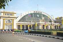
Bangkok is the location of Hua Lamphong Railway Station, the main terminus of the national rail network operated by the State Railway of Thailand (SRT). Trains travelling on the Northern Line to Chiang Mai, the Northeastern Line to Nong Khai and Ubon Ratchathani, and the Eastern Line to Aranyaprathet originate at the station, and so do some trains of the Southern Line, which terminates at Su-ngai Kolok and has a connection to Malaysia (the other Southern terminus is Thonburi). In addition to long-distance services, the SRT also operates a few daily commuter trains running from and to the outskirts of the city during the rush hour, but passenger numbers have remained low.
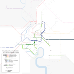
Rapid transit
Bangkok is currently served by three rapid transit systems: the BTS Skytrain, the underground MRT and the elevated Airport Rail Link.
| System | Began operation | Lines in operation | Lengths in operation | Stations in operation | Operators | |
|---|---|---|---|---|---|---|
| |
BTS Skytrain | 1999 | 2 | 38.69 km (24.04 mi)[2] | 35[3] | BTSC / BMA |
| |
MRT | 2004 | 2 | 43 km (27 mi) | 35[4] | BEM |
| Airport Rail Link | 2010 | 1 | 28.6 km (17.8 mi) | 8 | SRT | |
Skytrain
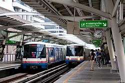
The Skytrain consists of two lines, totalling 33.5 kilometres (20.8 mi): Sukhumvit Line running southwards from Mo Chit Station in Chatuchak District along Phahon Yothin Road and then eastwards along Sukhumvit Road to Bearing Station in Bang Na District, and Silom Line which runs eastwards from National Stadium Station in Pathum Wan District, then southwest along Ratchadamri, Si Lom, Narathiwat Ratchanakharin and Sathon Roads, crossing the Chao Phraya passing Wong Wian Yai Station in Khlong San towards Bang Wa Station in Phasi Charoen District. Both lines are elevated, and interchange at Siam Station in Pathum Wan. Construction is ongoing to extend the eastern end of the Sukhumvit Line to Samut Prakan.
MRT (Metro)
The underground MRT system opened in July 2004, and currently consists of two lines, the Blue Line and Purple Line. The Blue Line runs for 20 kilometres (12 mi) from Bang Sue Station in a southward arc through the east along Ratchadaphisek Road, terminating at Hua Lamphong, where it connects to the central railway station. It has eighteen stations, and connects to the BTS system at BTS stations Mo Chit, Asok, and Sala Daeng. The Blue Line is being extended to form a circle, with a western portion along Charansanitwong Road on the western side of the city, and continuing further west to Bang Khae. The Purple Line opened in 2016.
Although initial passenger numbers were low and their service area remains limited to the inner city, these systems have become indispensable to many commuters. The BTS reported an average of 392,167 daily trips in 2010, while the MRT had 178,334 passenger trips per day. However, relatively high fare prices have kept these systems inaccessible to a portion of the population.
Airport Rail Link
The Airport Rail Link, opened in August 2010 after many delays, connects the city centre to Suvarnabhumi Airport in Samut Prakan Province to the east. It is operated by the SRT, and offers services between the airport and Makkasan where it connects with Phetchaburi Station of the MRT. It terminates at Phaya Thai Station, where it connects to the BTS. Its eight stations span a distance of 28 kilometres (17 mi).
Lines in operation
| Line | System | Stations | Length | Terminus | Daily ridership | Began operation | |
|---|---|---|---|---|---|---|---|
| Initial part | Last extension | ||||||
| BTS Sukhumvit Line | BTS Skytrain | 23[5] | 24.02 km (14.93 mi)[6] | Mo Chit ↔ Samrong[7] | combined 900,000[8] | 1999 | 2017[9] |
| BTS Silom Line | 13 | 14.67 km (9.12 mi) | National Stadium ↔ Bang Wa | 2013 | |||
| MRT Blue Line | Metropolitan Rapid Transit (MRT) | 19[10][11] | 20 km (12 mi)[12] | Hua Lamphong ↔ Tao Poon[13][14] | 240,000 | 2004 | 2017[15][16] |
| MRT Purple Line | 16 | 23 km (14 mi) | Khlong Bang Phai ↔ Tao Poon | 20,000[17] | 2016 | - | |
| ARL Airport Rail Link | Airport Rail Link | 8 | 28.6 km (17.8 mi) | Phaya Thai ↔ Suvarnabhumi | 49,000 | 2010 | - |
| Total | 110.29 km (68.53 mi) | ||||||
Future expansion
The entire Mass Rapid Transit Master Plan in Bangkok Metropolitan Region consists of eight main lines and four feeder lines totalling 508 kilometres (316 mi) to be completed by 2029.
Extensions to the Sukhumvit Line, Silom Line and MRT Blue Line are under construction, as well as the Light Red grade-separated commuter rail line to Taling Chan, to be run by the SRT.
In addition to rapid transit and heavy rail lines, there have been proposals for several monorail systems. In 2010 Grand Canal Land Company proposed a 600–800 metre line linking its properties on Rama IX Road with the Phra Ram 9 MRT Station, but failed to secure approval.[18][19]
See also
References
- ↑ Rujopakarn, Wiroj (October 2003). "Bangkok transport system development: what went wrong?". Journal of the Eastern Asia Society for Transportation Studies. 5: 3302–15.
- ↑ https://www.thansettakij.com/2016/07/14/70337
- ↑ https://www.thansettakij.com/2016/07/14/70337
- ↑ http://www.manager.co.th/iBizChannel/ViewNews.aspx?NewsID=9590000060145
- ↑ https://www.thansettakij.com/2016/07/14/70337
- ↑ https://www.thansettakij.com/2016/07/14/70337
- ↑ https://www.thansettakij.com/2016/07/14/70337
- ↑ http://www.thansettakij.com/2016/05/17/52501
- ↑ https://www.thansettakij.com/2016/07/14/70337
- ↑ http://www.thairath.co.th/content/763412
- ↑ http://www.matichon.co.th/news/334306
- ↑ M.R.T. Chaloem Ratchamongkhon Line Mass Rapid Transit Authority of Thailand. 2014
- ↑ http://www.thairath.co.th/content/763412
- ↑ http://www.matichon.co.th/news/334306
- ↑ http://www.thairath.co.th/content/763412
- ↑ http://www.matichon.co.th/news/334306
- ↑ PCL., Post Publishing. "Purple Line: Newly launched, but few using it". Retrieved 2016-08-31.
- ↑ "Developer puts Bangkok on track for nation's first monorail". Bangkok Post. March 7, 2010. Retrieved December 25, 2011.
- ↑ โมโนเรลแกรนด์คาแนลส่อวืด. Thansettakij (in Thai) (2628). 21–23 April 2011. Retrieved 28 July 2012.
External links
| Wikimedia Commons has media related to Rail transport in Bangkok. |
Public transport systems in Bangkok Metropolitan Region | ||||||||||||||||
|---|---|---|---|---|---|---|---|---|---|---|---|---|---|---|---|---|
| Rail |
| |||||||||||||||
| Buses | ||||||||||||||||
| Boats |
| |||||||||||||||
| Others |
| |||||||||||||||
| Smart cards | ||||||||||||||||
| High-speed rail | 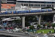 | |
|---|---|---|
| Commuter rail | ||
| Rapid transit | ||
| Light rail |
| |
| Monorail |
| |
| Tram |
| |
| People mover |
| |
| Bus rapid transit |
| |