Raid on Bir el Hassana
| ||||||||||||||||||||||||||||||||||

The Raid on Bir el Hassana (Hasna) occurred in the Sinai Peninsula in February 1917, during World War I. It was a minor action between an augmented battalion of the Imperial Camel Corps on the one side and a score of Turkish troops plus some armed Bedouin on the other. The raid is only notable because it occasioned the first aeromedical evacuation in the British Army, and possibly in history.
The raid was the third of three battles, if one may call it a battle, by British forces seeking to recapture the Sinai Peninsula during the Sinai and Palestine Campaign of World War I. Egyptian Expeditionary Force (EEF) cavalry and camelry traveled into the centre of the Sinai Peninsula to attack and push the last Turkish garrisons back into Palestine.
Background
British ships on the Mediterranean coast and the Gulf of Aqaba guarded the coast road via El Arish, and the road from Ma'an via Nekhl to the Suez Canal. Ottoman forces continued to occupy the area on the central way across the Sinai south from el Kossaima towards the Suez Canal, including Bir el Hassana and Nekhl.
The raid
General Archibald Murray, commander of the Egyptian Expeditionary Force, ordered attacks against both Nekhl and Bir el Hassana, which lay 40 miles (64 km) north of Nekhl, between the Gebel Helal and the Gebel Yelleg.[1][2] Three columns of cavalry and camelry set out with the goal of all attacking on 18 February. One column set out from Serapeaum (possibly the vicinity of Ismailia), and another from Suez on 13 February 1917 to converge on Nekhl.[3] Major J.R. Bassett, commanding 2nd Battalion (British), Imperial Camel Corps, together with the Hong Kong and Singapore (Mountain) Battery, marched from El Arish, via Magdhaba.[4]
This column reached Lahfan on the 16th,[3] and on the 17th advanced from Magdhaba. At dawn the next morning they surrounded the Ottoman Army garrison at Bir el Hassana, which consisted of three officers and 19 other ranks, reinforced by armed Bedouin. The Ottoman troops surrendered, but the Bedouin fired on the British, shattering a lance corporal's ankle. One of the Turks who surrendered was Nur Effendi, who had commanded the garrison at the unsuccessful British attack on Maghara on 15 October 1916. The troops searched Bir el Hassana and found 21 rifles, a few camels, and 2100 rounds of ammunition.[3]
After the surrender of Bir el Hassana, Bassett's force remained in position to capture any Ottoman force withdrawing back from Nekhl towards Bir el Hassana.[5]
Aeromedical evacuation
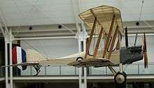
During the British attack, a Bedouin fired a bullet that shattered Lance corporal McGregor's ankle. On 19 February the Royal Flying Corps flew McGregor out with his leg in a box splint, with him sitting in the observer's seat of a Royal Aircraft Factory B.E.2c, a two-seater biplane.[6] The flight to El Arish took 45 minutes. The alternative to aeromedical evacuation was a cacolet (a type of litter) on a camel, which one historian described as "a form of travel exquisite in its agony for wounded men because of the nature of the animal's movement".[7] Travel by cacolet would have taken days.[6]
See also
Citations and references
- Citations
- References
- Dennis, Peter; Jeffrey Grey; Ewan Morris; Robin Prior (2008). The Oxford Companion to Australian Military History. with Jean Bou (2nd ed.). Melbourne: Oxford University Press, Australia & New Zealand. OCLC 489040963.
- Dolev, Eran (1986) "The First Recorded Aeromedical Evacuation in the British Army – The True Story". Journal of the Royal Army Medical Corps (132): 34–36.
- First World War Diaries AWM4 1/60, General Staff, Headquarters Anzac Mounted Division, Canberra: Australian War Memorial, May 1917
- Grant, Lieutenant Colonel W (May 1917), "Appendix 118: Report on Operations against Nekhl", First World War Diaries AWM4, 1-60-15PART1 (PDF), Canberra: Australian War Memorial
- Cutlack, Frederic Morley (1941). The Australian Flying Corps in the Western and Eastern Theatres of War, 1914–1918. Official History of Australia in the War of 1914–1918. Volume VIII (11th ed.). Canberra: Australian War Memorial. OCLC 220900299.
- Falls, Cyril; G. MacMunn (1930). Military Operations Egypt & Palestine from the Outbreak of War with Germany to June 1917. Official History of the Great War Based on Official Documents by Direction of the Historical Section of the Committee of Imperial Defence. Volume 1. London: HM Stationery Office. OCLC 610273484.
- Gullett, Henry S. (1941). The Australian Imperial Force in Sinai and Palestine, 1914–1918. Official History of Australia in the War of 1914–1918. Volume VII (11th ed.). Canberra: Australian War Memorial. OCLC 220900153.
- Murray, Sir Archibald James (1920) Sir Archibald Murray's despatches (June 1916 – June 1917). (J.M. Den).
Coordinates: 30°28′01″N 33°46′48″E / 30.467°N 33.78°E