Rafael Freyre
| Rafael Freyre | |
|---|---|
| Municipality | |
|
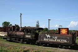
Train on the land of Rafael Freyre's sugar cane factory | |
.png) Rafael Freyre municipality (red) within Holguín Province (yellow) and Cuba | |
 Location of Rafael Freyre in Cuba | |
| Coordinates: 21°01′41″N 75°59′47″W / 21.02806°N 75.99639°WCoordinates: 21°01′41″N 75°59′47″W / 21.02806°N 75.99639°W | |
| Country |
|
| Province | Holguín |
| Area[1] | |
| • Total | 620 km2 (240 sq mi) |
| Elevation | 25 m (82 ft) |
| Population (2004)[2] | |
| • Total | 50,080 |
| • Density | 80.8/km2 (209/sq mi) |
| Time zone | EST (UTC-5) |
| Area code(s) | +53-24 |
Rafael Freyre is a municipality and town in the Holguín Province of Cuba.
Overview
The main municipal settlement (Rafael Freyre itself) developed around the sugar cane factory "Central Santa Lucía".[3]
Some of its most popular destinations are the north coast beaches such as Playa Guardalavaca and Guardalavaca, which are both natural white sand beaches in the bordering municipality of Banes.
In a small village called "Bariay" on the north coast there is a monument that marks the arrival of Christopher Columbus.
Demographics
In 2004, the municipality of Rafael Freyre had a population of 50,080.[2] With a total area of 620 km2 (240 sq mi),[1] it has a population density of 80.8/km2 (209/sq mi).
See also
References
- 1 2 Statoids. "Municipios of Cuba". Retrieved 2007-10-05.
- 1 2 Atenas.cu (2004). "2004 Population trends, by Province and Municipality" (in Spanish). Retrieved 2007-10-05.
- ↑ MatK2 (2008). "Sugar Mill" (in Spanish). Retrieved 2009-10-12.
External links
![]() Media related to Rafael Freyre at Wikimedia Commons
Media related to Rafael Freyre at Wikimedia Commons