United States National Radio Quiet Zone
The National Radio Quiet Zone (NRQZ) is a large area of land in the United States in which radio transmissions are strictly restricted by law to facilitate scientific research and military intelligence. It is located in the states of West Virginia, Virginia, and a tiny part of Maryland.
Location
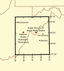
The Quiet Zone is an approximate rectangle of land, 107.0 miles (172.2 km) on the north edge, 109.6 miles (176.4 km) on the south edge and 120.9 miles (194.6 km) on the east and west edges, comprising approximately 13,000 square miles (34,000 km2). It straddles the borders of Virginia and West Virginia, and also includes a sliver of Maryland. The NRQZ is centered between the National Radio Astronomy Observatory (NRAO) in Green Bank, West Virginia, and Sugar Grove Station in Sugar Grove, West Virginia. It includes all land with latitudes between 37° 30′ 0.4″ N and 39° 15′ 0.4″ N, and longitudes between 78° 29′ 59.0″ W and 80° 29′ 59.2″ W.[1]
Restrictions


Most broadcast transmitters in the Quiet Zone are forced to operate at reduced power and use highly directional antennas. This makes cable and satellite all but essential for acceptable television in much of the region. Restrictions on transmissions are tightest within ten miles of the NRAO and Sugar Grove facilities,[4] where most omnidirectional and high-power transmissions are prohibited.
Not all radio transmissions are prohibited in the Radio Quiet Zone. For example, emergency service (police, fire, and ambulance) radios and Citizen's Band radio are permitted. However, large transmitter owners must typically coordinate their operations with the NRAO. The only broadcast radio stations in the inner core of the Quiet Zone are part of the Allegheny Mountain Radio network—with just one station in the AM band, and several low-power FM stations. Exceptions to the Quiet Zone restrictions are usually determined on a case-by-case basis, with preference given to public safety concerns, such as remote alarm systems, repeaters for emergency services, and NOAA Weather Radio.
The most severe restrictions imposed on the general public are only in place within the 20 mile radius of the Green Bank Telescope.[5] The NRAO actively police the area for devices emitting noticeably high amounts of electromagnetic radiation such as microwave ovens, WiFi routers and faulty electrical equipment and request citizens discontinue their usage. They possess no legal powers of enforcement[6] (although the FCC can still impose a fine of $50 on violators[7]), but will work with residents to find solutions.[8][9]
Cellular telephone use in the zone is also highly restricted.[5] Most residents do not own a cellular phone unless they travel out of the area regularly.[10]
Zones of protection

The Green Bank Interference Protection Group maintains policies to manage radio frequency interference by divining into 5 zones based on available legal instruments.[11][12]
Zone 1 and zone 2 are located within the property of NRAO. The entire NRAO property is designed as zone 1 except small portions (such as housing, visitor and laboratory areas) that are designed as zone 2. Zone 1, also called Radio Astronomy Instrument Zone , restricts intentional radiators to only those are deemed essential. All unintentional radiators must be operated within the ITU-R RA.769 recommendations on protection criteria used for radio astronomical measurements. Gasoline-powered motor vehicles are forbidden within zone 1 as the ignition system on spark-ignited engines generates noticeable radio interference, resulting in all vehicles and equipment needing to be diesel powered.[13] Zone 2, also called Observatory Building Zone, allows intentional radiators licensed by National Radio Quiet Zone, but not other radiators such as WIFI, cordless phones and wireless equipment. Certain types of unintentional radiators are allowed.
Zone 3 and zone 4 are governed by The Radio Astronomy Zoning Act which is the Chapter 37A of the West Virginia Code. It strictly regulates radio transmitters within 2 miles and 10 miles of the NRAO facility respectively.[4] Within these zones, the interferences to observations will be identified and documented. The owners of the offending equipment will be personally visited to request for cooperation to eliminate the interferences. The enforcement will be used as a last resort. Enforcement in zone 4 may be more lenient than limit set in the Chapter 37A.
Zone 5 is the boundary of National Radio Quiet Zone. The enforcement policies for this zone are managed by the National Radio Quiet Zone Administrator at NRAO.
Uses
The Quiet Zone was created by the Federal Communications Commission (FCC) in 1958 to protect the radio telescopes at Green Bank and Sugar Grove from harmful interference.[14] Today, the NRAO oversees the Quiet Zone, in agreement with the Sugar Grove facility.
The Quiet Zone protects the telescopes of the NRAO facility, and the antennas and receivers of the U.S. Navy's Information Operations Command (NIOC) at Sugar Grove. The NIOC has long been the location of electronic intelligence-gathering systems, and is today said to be a key station in the ECHELON system operated by the National Security Agency (NSA).[15]
The area has also attracted people who believe they suffer from electromagnetic hypersensitivity.[16][17]
Counties inside the Zone
Maryland counties
- Extreme southern Garrett County
Virginia counties
- See also List of radio stations in Virginia, which includes several AM and FM stations within the zone.
- Western Albemarle County
- Alleghany County
- Amherst County, except for the southern quarter
- Extreme northern Appomattox County
- Augusta County
- Bath County
- Extreme northern Bedford County
- Northern Botetourt County
- Northwestern Buckingham County
- Northern Craig County
- Western Greene County
- Highland County
- Nelson County
- Western Page County
- Rockbridge County
- Rockingham County, except for a small area in the extreme eastern part
- Western Shenandoah County
West Virginia counties
- See also List of radio stations in West Virginia, which includes several AM and FM stations within the zone.
- Barbour County, except for a small area in the north
- Extreme eastern Braxton County
- Grant County, except for an area in the north
- Eastern Greenbrier County
- Southwestern Hampshire County
- Hardy County
- Southeastern Harrison County
- Eastern Lewis County
- Extreme southern Mineral County
- Northeastern and east central Monroe County
- Extreme eastern Nicholas County
- Pendleton County
- Pocahontas County
- Two areas in extreme southwestern and southeastern Preston County
- Randolph County
- Extreme southern Taylor County
- Tucker County, except for an area in the extreme northern part
- Upshur County
- Central and eastern Webster County
Cities inside the Zone
Virginia cities
- Buena Vista
- The western half of Charlottesville, including much of the University of Virginia Grounds
- Covington
- Harrisonburg
- Lexington
- Staunton
- Waynesboro
West Virginia cities
- Outside
Clarksburg, West Virginia, and Lynchburg, Virginia are just outside the Quiet Zone.
See also
References
- ↑ "National Radio Quiet Zone". National Radio Astronomy Observatory. Retrieved February 20, 2015.
- ↑ Casto, James E. (9 July 2014). "NRAO Vehicle Fleet". The State Journal. Retrieved 31 October 2016.
- ↑ Bucktin, Christopher (28 July 2015). "Telescope Town can hear to within second of the Big Bang but won't let locals use mobiles". Mirror. Retrieved 31 October 2016.
- 1 2 "West Virginia Code, Chapter 37A". Chuck Niday - National Radio Astronomy Observatory. Retrieved 2013-10-08.
- 1 2 Hu, Elise (Oct 8, 2013). "Enter The Quiet Zone: Where Cell Service, Wi-Fi Are Banned". National Public Radio. Retrieved 2013-10-08.
To keep the zone protected from signals that could confuse the telescope, Niday and others from the NRAO drive the 20-mile radius around the Green Bank Telescope weekly, policing for possible interference.
- ↑ Holba, Emile; Hall, Sara Jane (19 May 2015). "The Quiet Zone: Where mobile phones are banned". BBC. Retrieved July 14, 2016.
- ↑ "West Virginia Code, Chapter 37A". National Radio Astronomy Observatory. Retrieved July 14, 2016.
- ↑ Sizemore, Wes; Acree, Jeff. "The National Radio Quiet Zone" (PDF). NRAO. Retrieved July 14, 2016.
NRAO operates the National Radio Quiet Zone at Green Bank. We briefly outline its salient characteristics, and our experience with its day to day operation.
- ↑ ""National Radio Quiet Zone"... (Parkersburg, Elkins: construction, living, zip code) - West Virginia (WV) - City-Data Forum". city-data.com. Retrieved July 14, 2016.
- ↑ Sterman, Joce (June 26, 2016). "'Full Measure': The No-Fi zone". WGME. Retrieved July 14, 2016.
- ↑ Beaudet, C.; Clark, C.; Niday, C.; Ghigo, F.; Ford, J.; McCullough, R.; Sizemore, W.; Woody, P. (24 January 2007). "The Green Bank Interference Protection Group: Policies for RFI Management".
- ↑ "NRAO Green Bank Policies for RFI Management". Retrieved 31 October 2016.
- ↑ "NRAO Green Bank Site RFI Regulations for Visitors" (PDF). National Radio Astronomy Observatory. p. 2. Retrieved October 14, 2016.
- ↑ "National Radio Quiet Zone - National Radio Astronomy Observatory".
- ↑ "Interception Capabilities 2000, Sugar Grove, Virginia – COMSAT interception at ECHELON site". Interception of Communications Section. Leeds, UK: Cyber-Rights & Cyber-Liberties (UK). May 11, 1999. Archived from the original on May 30, 2008. Retrieved September 14, 2011.
Interception Capabilities 2000 Report to the Director General for Research of the European Parliament (Scientific and Technical Options Assessment programme office) on the development of surveillance technology and risk of abuse of economic information.
- ↑ O'Brien, Jane; Danzico, Matt (September 12, 2011). "'Wi-fi refugees' shelter in West Virginia mountains". BBC News. Retrieved September 13, 2011.
- ↑ "The town that banned Wi-Fi". The Guardian. Retrieved 21 June 2015.
External links
- "National Radio Quiet Zone". National Radio Astronomy Observatory. Retrieved February 20, 2015. - Official website
Coordinates: 38°22′30″N 79°30′00″W / 38.375°N 79.5°W
- The Town Without Wi-Fi—Washingtonian (January 2015)