RAF Haverfordwest
| RAF Haverfordwest | |||||||||||
|---|---|---|---|---|---|---|---|---|---|---|---|
| Near Haverfordwest, Pembrokeshire in Wales | |||||||||||
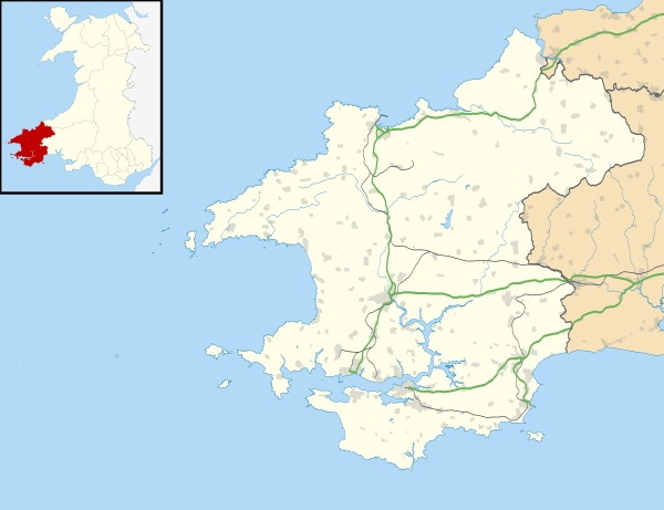 RAF Haverfordwest Shown within Pembrokeshire | |||||||||||
| Coordinates | 51°49′53″N 004°57′49″W / 51.83139°N 4.96361°WCoordinates: 51°49′53″N 004°57′49″W / 51.83139°N 4.96361°W | ||||||||||
| Type | Royal Air Force station | ||||||||||
| Site information | |||||||||||
| Owner | Air Ministry | ||||||||||
| Operator | Royal Air Force | ||||||||||
| Site history | |||||||||||
| Built | 1942 | ||||||||||
| In use | 1943-1945 | ||||||||||
| Airfield information | |||||||||||
| Elevation | 44 metres (144 ft) AMSL | ||||||||||
| |||||||||||
Royal Air Force Haverfordwest or more simply RAF Haverfordwest is a former Royal Air Force station located 2.1 miles (3.4 km) north of Haverfordwest, Pembrokeshire and 11 miles (18 km) south of Fishguard, Pembrokeshire, Wales.
It was operational between 1943 and 1945 and was controlled by No.17 Group of RAF Coastal Command.
History
The following units were here posted here at some point:
- No. 3 (Coastal) Operational Training Unit RAF.[1]
- No. 4 Refresher Flying Unit RAF.[1]
- No. 7 (Coastal) Operational Training Unit RAF.[1]
- No. 8 (Coastal) Operational Training Unit RAF.[1]
- No. 20 Air Crew Holding Unit RAF.[1]
- No. 21 Air Crew Holding Unit RAF.[1]
- No. 516 Squadron RAF.[1]
- General Reconnaissance Aircraft Preparation Pool.[1]
- Navigators ‘W’ Holding Course.[1]
- Polish Flight.[1]
Current use
The site is currently used by Haverfordwest Aerodrome, a public-use general aviation airport.
See also
References
Royal Air Force portal | ||
| Formations and units |  | |
| Branches and components | ||
| Reserve forces | ||
| Associated civil organizations | ||
| Equipment | ||
| Personnel | ||
| Appointments | ||
| Symbols and uniform | ||
This article is issued from Wikipedia - version of the 2/28/2015. The text is available under the Creative Commons Attribution/Share Alike but additional terms may apply for the media files.