Quneitra District
| Quneitra District منطقة القنيطرة | |
|---|---|
| District | |
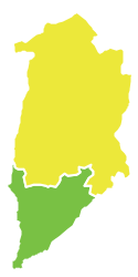 Map of Quneitra District within Quneitra Governorate. Quneitra District is in yellow. | |
| Coordinates (Quneitra): 33°07′32″N 35°49′26″E / 33.1256°N 35.8239°ECoordinates: 33°07′32″N 35°49′26″E / 33.1256°N 35.8239°E | |
| Country |
|
| Governorate | Quneitra |
| Seat | Quneitra |
| Subdistricts | 4 nawāḥī |
| Area | |
| • Total | 1,312.57 km2 (506.79 sq mi) |
| Population (2004)[1] | |
| • Total | 64,680 |
| • Density | 49/km2 (130/sq mi) |
| Geocode | SY1400 |
Quneitra (or al-Qunaytirah) District (Arabic: منطقة القنيطرة, translit. manṭiqat al-Qunayṭrah) is a district of the Quneitra Governorate in southern Syria. Part of the district has been occupied by Israel since 1967, part has been in the Area of Separation of the U.N. Disengagement Observer Force Zone since 1974, and part is under Syrian control.
Administrative centre is the city of Quneitra. At the 2004 census, the district had a population of 64,680.[1]
Sub-districts
The district of Quneitra is divided into four sub-districts or nawāḥī (population as of 2004[1]):
| Code | Name | Area | Population |
|---|---|---|---|
| SY140000 | Quneitra nahiyah | 332.75 km² | 4,318 |
| SY140001 | Jabta El-Hashab nahiyah | 368.68 km² | 42,980 |
| SY140002 | Hushnia nahiyah | 346.15 km² | 17,382 |
| SY140003 | Massade nahiyah | 264.99 km² | 0 |
References
- 1 2 3 "General Census of Population and Housing 2004" (PDF) (in Arabic). Syrian Central Bureau of Statistics. Retrieved 15 October 2015. Also available in English: "2004 Census Data". UN OCHA. Retrieved 15 October 2015.
This article is issued from Wikipedia - version of the 6/10/2016. The text is available under the Creative Commons Attribution/Share Alike but additional terms may apply for the media files.