Queen's, Kingston
| Queen's | |
|---|---|
| Neighbourhood | |
|
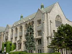
Douglas Library, Queen's University | |
| Coordinates: 44°13′48″N 76°29′44″W / 44.23000°N 76.49556°WCoordinates: 44°13′48″N 76°29′44″W / 44.23000°N 76.49556°W | |
| Country | Canada |
| Province | Ontario |
| City | Kingston, Ontario |
| Population | |
| • Total | 1,255 |
| Time zone | Eastern Time Zone (UTC-5) |
| • Summer (DST) | Eastern Time Zone (UTC-4) |
| Postal code | K7L |
| Area code(s) | 613 |
Queen's is a neighbourhood located in downtown Kingston, Ontario, Canada. The Queen's district is bounded by Princess Street to the north, Albert Street to the west, Barrie Street to the east, and Lake Ontario to the south. The neighbourhood is home to Queen's University and Kingston General Hospital. There is a large student population due to the proximity to the university. The large majority of homes are rental properties, as there is only 9.7% homeownership in the neighbourhood.[1]
The average family income in the neighbourhood is $76,210, slightly below the city average. Landmarks include Queen's University, Victoria Park, Breakwater Park along Lake Ontario, Kingston Collegiate and Vocational Institute, and an area known as The Hub at the intersection of Princess and Division Streets. This area is known for its numerous bars and nightclubs that cater to the student population.
See also Kingston Student Ghetto.
References
- ↑ "Archived copy" (PDF). Archived from the original (PDF) on February 21, 2012. Retrieved March 2, 2012. Kingston Economic Development Corporation Neighbourhood Profiles