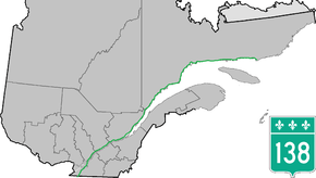
Quebec Route 138
| ||||
|---|---|---|---|---|
| Chemin Du Roy | ||||
 | ||||
| Route information | ||||
| Maintained by Transports Québec | ||||
| Length: | 1,389.3 km[1] (863.3 mi) | |||
| Major junctions | ||||
| West end: |
| |||
|
| ||||
| East end: |
Kegaska (present) Boul Camille Marcoux in Blanc Sablon to Route 510 (future) | |||
| Highway system | ||||
| ||||

Route 138 is a major highway in the Canadian province of Quebec, following the entire north shore of the Saint Lawrence River past Montreal to the eastern terminus in Kegashka on the Gulf of Saint Lawrence. The western terminus is in Elgin, at the border with New York State south-west of Montreal (connecting with New York State Route 30 at the Trout River Border Crossing). Part of this highway is known as the Chemin du Roy, or King's Highway, which is one of the oldest highways in Canada.
It passes through the Montérégie, Lanaudière, Mauricie, Capitale-Nationale and Côte-Nord regions of Quebec. In Montreal, Highway 138 runs via Sherbrooke Street, crosses the Pierre Le Gardeur Bridge to Charlemagne and remains a four-lane road until exiting Repentigny.
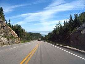
This highway takes a more scenic route than the more direct Autoroute 40 between Montreal and Quebec City. It crosses the Saguenay River via a ferry which travels between Baie-Sainte-Catherine and Tadoussac.
Until the mid-1990s, the highway's eastern terminus was Havre-Saint-Pierre, but in 1996 the extension to Natashquan was completed. A 40km section between Natashquan and Kegashka opened on September 26, 2013, with the inauguration of a bridge across the Natashquan River.[2][3]
A second segment of about 17 km extends from Tete-a-la-Baleine's airport, east through Tête-à-la-Baleine, Quebec, to the ferry terminal southeast of Tete-a-la-Baleine. There is also a 10.7 km roadway, la route Mecatina, from Mutton Bay to a ferry terminal in La Tabatiere and continuing beyond.
A third segment of Route 138 extends from Old Fort to Blanc-Sablon on the eastern end of the Côte-Nord.[4]
A gap remains between Kegashka and Old Fort, through isolated communities accessible only by coastal ferry. On August 25, 2006, the Quebec government announced a 10-year project to connect the two segments by building 425 km of highway along the Lower North Shore.[5]
Municipalities along Route 138
See also
- Quebec Route 2 (historical) and Chemin du Roy
- List of Quebec provincial highways
References
- ↑ Ministère des transports, "Distances routières", page 66-69, Les Publications du Québec, 2005
- ↑ "Une nouvelle route pour Kegaska".
- ↑ "Le pont de Natashquan inauguré".
- ↑ Trans-Labrador Hwy - Labrador 2003 - Page 5
- ↑ "Québec invests an extra $122 million for the extension of route 138 on the Basse-Côte-Nord". Gouvernement du Québec. May 30, 2011. Retrieved 2013-11-07.
External links
| Wikimedia Commons has media related to Quebec Route 138. |
- Provincial Route Map (Courtesy of the Quebec Ministry of Transportation) (French)
- Overview Google map for QC 138 from Montreal border to Natashquan
- Overview Google map for QC 138 from Montreal to New York border
- Overview Google map for QC 138 from dead end to Newfoundland and Labrador border