Punta Eugenia
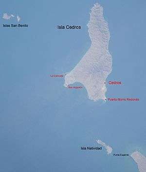
This annotated Space Shuttle photo shows Punta Eugenia bottom right. Cedros Island is in the center.
Punta Eugenia is a headland in the Mulegé Municipality, and is the westernmost point on the mainland of the state of Baja California Sur. To its north west lie Isla Natividad, Cedros Island and the Islas San Benito.
The pattern of ocean currents and eddies around Punta Eugenia has been shown to be a significant phylogeographic break in the distribution of fish species.[1]
References
- ↑ Bernardi G, Findley L, Rocha-Olivares A (2003). "Vicariance and dispersal across Baja California in disjunct marine fish populations" (PDF). Evolution. The Society for the Study of Evolution. 57 (7): 1599–1609. doi:10.1554/02-669. PMID 12940364. Retrieved August 27, 2013.
Coordinates: 27°50′49″N 115°4′54″W / 27.84694°N 115.08167°W
This article is issued from Wikipedia - version of the 6/5/2016. The text is available under the Creative Commons Attribution/Share Alike but additional terms may apply for the media files.