Pripyshminskiye Bory National Park
| Pripyshminskiye Bor National Park | |
|---|---|
| Припышминские Боры (Russian) | |
|
IUCN category II (national park) | |
|
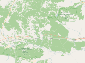
Pripyshminskiye Bory National Park (2 sections, dark green. Tugulymskaya (upper right), Talitsky (lower left) | |
 Location of Park | |
| Location | Tugulymsky District of Sverdlovsk Oblast |
| Nearest city | Yekaterinburg |
| Coordinates | 56°59′N 63°47′E / 56.983°N 63.783°ECoordinates: 56°59′N 63°47′E / 56.983°N 63.783°E |
| Area | 49,050 hectares (121,205 acres; 490 km2; 189 sq mi) |
| Established | 1993 |
| Governing body | FGBU Pripyshminskiye Bory |
| Website | http://www.nppbor.ru/ |
Pripyshminskiye Bory National Park (Russian: Припышминские Боры). The Pripyshminskiye forest is located in the southwestern corner of the West Siberian Plain . It protects a complex of pine and birch forests. About 10% of the area is non-forested marshes, ponds, hayfields and pastures. The park is located in the Sverdlovsk Oblast, 150 km east of the city of Yekaterinburg and 70 miles west of Tyumen. The route of the Trans-Siberian Railroad passes by the two sections of the park.[1]
Topography
Pripyshminskiye Bory National Park is divided into two sections. The Talisky section, which is on the right bank of the Pyshma River, is just south and east of the town of Talitsa. It a relatively flat forest of pine, spruce and larch. The second section, Tugulymskaya, is located 20 miles to the northeast, in Tugulymsky District. It has more extensive swamps and wetlands on the floodplains of the Pyshma River, with forest of larch, fir and cedar.[2] Much of this section is swamp, with some higher sandy ground supporting pine forest.
Climate
The climate in the Pripyshminskiye forest is Humid continental climate (Köppen climate classification Dfb), characterized by large seasonal temperature differences, with warm to hot (and often humid) summers and cold (sometimes severely cold) winters. Precipitation is relatively well distributed through the year; average annual precipitaion is 17 inches.[3]
| Pripyshminskie forest, Sverdlovsk, Russia | ||||||||||||||||||||||||||||||||||||||||||||||||||||||||||||
|---|---|---|---|---|---|---|---|---|---|---|---|---|---|---|---|---|---|---|---|---|---|---|---|---|---|---|---|---|---|---|---|---|---|---|---|---|---|---|---|---|---|---|---|---|---|---|---|---|---|---|---|---|---|---|---|---|---|---|---|---|
| Climate chart (explanation) | ||||||||||||||||||||||||||||||||||||||||||||||||||||||||||||
| ||||||||||||||||||||||||||||||||||||||||||||||||||||||||||||
| ||||||||||||||||||||||||||||||||||||||||||||||||||||||||||||
Ecoregion
The terrestrial ecoregion of Pripyshminskiye is Western Siberian Taiga (WWF ID#611), a region characterized by coniferous forests of pine, spruce and larch.[4] The freshwater ecoregion is classified as "Ob River Basin" (FEOW ID#602), characterized by plains river topography, continental climate, and complexes of freshwater fish that in the lower latitudes include boreal river families such as northern pike, loach and dace.[5]
Tourism
The park as zones for strict nature protection, for cultural tourism (including several eco-trails), and recreation (such as berry-picking, mushroom collecting). There are developed hiking trails and campsites are available with tent sites and huts. The park also sponsor a nature museum and baths.[1]
See also
References
- 1 2 "Pripyshminskie Bora National Park" (in Russian). FGBU Pripyshminskie Bora. Retrieved December 31, 2015.
- ↑ "Pripyshminskiye Bor" (in Russian). Wild Russia. Retrieved December 31, 2015.
- ↑ "Climate of Pripysminskie forest". GlobalSpecies.org. Retrieved December 31, 2015.
- ↑ "Western Siberian Taiga". GlobalSpecies.org. Retrieved December 31, 2015.
- ↑ "Ob River Deainage Ecoregion". Freshwater Ecoregions of the World (FEOW). Retrieved December 31, 2015.
