Preston Brook
| Preston Brook | |
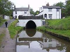 Preston Brook canal tunnel |
|
 Preston Brook |
|
| Population | 716 (2001 Census) |
|---|---|
| OS grid reference | SJ5881 |
| Civil parish | Preston Brook |
| Unitary authority | Halton |
| Ceremonial county | Cheshire |
| Region | North West |
| Country | England |
| Sovereign state | United Kingdom |
| Post town | RUNCORN |
| Postcode district | WA7 |
| Dialling code | 01928 |
| Police | Cheshire |
| Fire | Cheshire |
| Ambulance | North West |
| EU Parliament | North West England |
| UK Parliament | Weaver Vale |
Coordinates: 53°19′05″N 2°39′14″W / 53.318°N 2.654°W
Preston Brook is a civil parish in the borough of Halton, a unitary authority in the ceremonial county of Cheshire. It is located to the south-east of Runcorn and south-west of Warrington, adjacent to the M56 motorway. It contains the villages of Preston Brook and Preston on the Hill.
In the 2001 Census, the civil parish of Preston Brook had 312 dwellings and 716 residents.[1] Approximately 3,000 people are employed in the area. Preston Brook has a small industrial park called Abbot's Park, formerly used by the mobile telephone company O2 and Wincanton Logistics, though it is now used by Scottish Power and Marks & Spencer, among others.
The Bridgewater Canal runs from Manchester through Preston Brook where it divides into two branches. One branch leads to Runcorn where it used to join the Manchester Ship Canal, and before that the River Mersey, while the other branch joins the Trent and Mersey Canal at the Preston Brook canal tunnel. The community has a website and a bi-monthly newsletter.[2]
See also
References
- ↑ "2001 Census: Preston Brook". Office for National Statistics. Retrieved 14 June 2008.
- ↑ http://www.prestonbrook.com
| Wikimedia Commons has media related to Preston Brook. |
Cheshire Portal | |
| Unitary authorities | |
| Major settlements | |
| Rivers | |
| Topics | |