Poydras, Louisiana
| Poydras | |
| Census-designated place | |
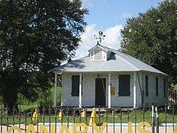 Historic Canary Islanders Home, Poydras | |
| Country | United States |
|---|---|
| State | Louisiana |
| Parish | St. Bernard |
| Elevation | 7 ft (2.1 m) |
| Coordinates | 29°52′11″N 89°53′20″W / 29.86972°N 89.88889°WCoordinates: 29°52′11″N 89°53′20″W / 29.86972°N 89.88889°W |
| Area | 4.4 sq mi (11.4 km2) |
| - land | 4.2 sq mi (11 km2) |
| - water | 0.2 sq mi (1 km2), 4.55% |
| Population | 3,886 (2000) |
| Density | 934.2/sq mi (360.7/km2) |
| Timezone | CST (UTC-6) |
| - summer (DST) | CDT (UTC-5) |
| Area code | 504 |
 Location in St. Bernard Parish and the state of Louisiana. | |
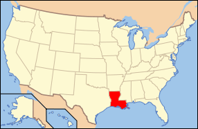 Location of Louisiana in the United States | |
Poydras is a census-designated place (CDP) in St. Bernard Parish, Louisiana, United States. The population was 3,886 at the 2000 census. It is part of the New Orleans–Metairie–Kenner Metropolitan Statistical Area. Poydras is on the East Bank of the Mississippi River, just upriver from the Plaquemines Parish line.
History
Poydras was first settled in the 18th century by Isleños when Louisiana was a Spanish colony. Presumably, the town is named for Julien Poydras.
Albert Estopinal, Jr., a St. Bernard Parish district attorney, judge, and sheriff, was born in Poydras in 1869 to later U.S. Representative, Albert Estopinal, Sr.[1]
The locally constructed levee failed during the 1922 flood and the community of Poydras was destroyed. Some historians claim that the levee break was intentional to save the City of New Orleans.[2] The New Orleans river stage dropped .2 foot within 24 hours of the Poydras crevasse and a sound levee had been inspected and reported only 30 minutes before the breach occurred.[3]
Poydras was severely damaged by the impact of Hurricane Katrina on 29 August 2005.
Geography
Poydras is located at 29°52′11″N 89°53′20″W / 29.86972°N 89.88889°W (29.869696, -89.888955).[4]
According to the United States Census Bureau, the CDP has a total area of 4.4 square miles (11 km2), of which, 4.2 square miles (11 km2) of it is land and 0.2 square miles (0.52 km2) of it (4.81%) is water.
Demographics
As of the census[5] of 2000, there were 3,886 people, 1,361 households, and 1,023 families residing in the CDP. The population density was 934.2 people per square mile (360.7/km²). There were 1,518 housing units at an average density of 364.9 per square mile (140.9/km²). The racial makeup of the CDP was 87.88% White, 8.65% African American, 0.77% Native American, 0.57% Asian, 0.05% Pacific Islander, 0.54% from other races, and 1.54% from two or more races. Hispanic or Latino of any race were 5.22% of the population.
There were 1,361 households out of which 38.1% had children under the age of 18 living with them, 52.8% were married couples living together, 16.2% had a female householder with no husband present, and 24.8% were non-families. 19.5% of all households were made up of individuals and 4.6% had someone living alone who was 65 years of age or older. The average household size was 2.84 and the average family size was 3.25.
In the CDP the population was spread out with 27.9% under the age of 18, 9.8% from 18 to 24, 31.5% from 25 to 44, 22.0% from 45 to 64, and 8.7% who were 65 years of age or older. The median age was 34 years. For every 100 females there were 96.4 males. For every 100 females age 18 and over, there were 94.3 males.
The median income for a household in the CDP was $26,820, and the median income for a family was $33,036. Males had a median income of $31,677 versus $20,716 for females. The per capita income for the CDP was $12,874. About 12.8% of families and 13.8% of the population were below the poverty line, including 8.8% of those under age 18 and 21.0% of those age 65 or over.
Education
Residents are zoned to schools in the St. Bernard Parish Public Schools.
As of 2015 Chalmette High School serves the population.
References
- ↑ "Estopinal, Jr., Albert". lahistory.org. Retrieved January 8, 2011.
- ↑ Kelman, Ari. (2003) A river and its city: the nature of landscape in New Orleans. Berkeley and Los Angeles, CA: University of California Press, p. 173. ISBN 0-520-23432-4.
- ↑ Bragg, Marion. (1977) Historic names and places on the lower Mississippi River. Vicksburg, Miss: Mississippi River Commission. p. 253. Retrieved 17 August 2015. US Army Corp of Engineers website
- ↑ "US Gazetteer files: 2010, 2000, and 1990". United States Census Bureau. 2011-02-12. Retrieved 2011-04-23.
- ↑ "American FactFinder". United States Census Bureau. Retrieved 2008-01-31.
| Wikimedia Commons has media related to Poydras, Louisiana. |
Municipalities and communities of St. Bernard Parish, Louisiana, United States | ||
|---|---|---|
| CDPs | 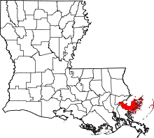 | |
| Unincorporated communities |
| |
| Ghost towns | ||