Port Hedland, Western Australia
| Port Hedland Western Australia | |||||||
|---|---|---|---|---|---|---|---|
.JPG) Esplanade Hotel, Port Hedland, April 2012. | |||||||
 Port Hedland | |||||||
| Coordinates | 20°18′36″S 118°36′04″E / 20.31000°S 118.60111°ECoordinates: 20°18′36″S 118°36′04″E / 20.31000°S 118.60111°E | ||||||
| Population | 15,191 (2015)[1] | ||||||
| Established | 1880s | ||||||
| Postcode(s) | 6721 | ||||||
| Elevation | 6 m (20 ft) | ||||||
| Time zone | AWST (UTC+8) | ||||||
| Location |
| ||||||
| LGA(s) | Town of Port Hedland | ||||||
| State electorate(s) | Pilbara | ||||||
| Federal Division(s) | Durack | ||||||
| |||||||
Port Hedland (Kariyarra: Marapikurrinya) is the second largest town[2] in the Pilbara region of Western Australia, with an estimated urban population of 15,191,[1] including the satellite town of South Hedland, 18 km away. It is also the site of the highest tonnage port in Australia.[3]
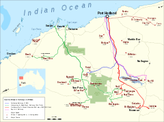
Port Hedland has a natural deep anchorage harbour which, as well as being the main fuel and container receival point for the region, was seen as perfect for shipment of the iron ore being mined in the ranges located inland from the town. The ore is moved by railway from four major iron ore deposits to the east and south of Port Hedland area. In August 2010 the port exported 13.6 million tonnes of iron ore.[4] In March 2016 a new monthly record of 39.6m tons was set.[5]
Other major resource activities supported by the town include the offshore natural gas fields, salt, manganese, and livestock. Grazing of cattle and sheep was formerly a major revenue earner for the region but this has slowly declined. Port Hedland was also formerly the terminus for the WAGR Marble Bar Railway which serviced the gold mining area of Marble Bar. Located between Port Hedland and South Hedland are the large salt hills of Dampier Salt, a subsidiary of Rio Tinto. These large mounds have almost become a tourist attraction in their own right.
History
Port Hedland is known by the Indigenous Kariyarra and Nyamal people as Marapikurrinya, which either means "place of good water" (as told by a Nyamal language speaker) and makes reference to the three reliable fresh water soaks that can still be seen in and around the town, or as the town council's website says "refers to the hand like formation of the tidal creeks coming off the harbour (marra - hand, pikurri - pointing straight and nya - a place name marker)".[6] According to Dreamtime legend there was a huge blind water snake living in the landlocked area of water known as Jalkawarrinya. This landlocked area is now the turning basin for the ships that enter the port and as the story goes, "the coming of the big ships meant it was unable to stay".
Though the coastline in the area had been explored in the 18th century, Captain Peter Hedland was one of the first Europeans to explore the harbour for the purpose of developing an export port. Peter Hedland arrived in the area in April 1863 onboard his boat, Mystery that he had built himself at Point Walter on the banks of the Swan River. He named the harbour Mangrove Harbour and reported that it would make a good landing site with a well protected harbour and that there was also fresh water available. Hedland failed to point out that the harbour was difficult to enter because of a sandbar that sealed the entrance, meaning it was only accessible at high tide and that it was difficult to enter in bad weather because of the narrow entrance.[7]
In 1866, the Government Resident at Roebourne, Robert John Sholl directed Charles Wedge to explore Port Hedland as an alternative port since, although Roebourne had been chosen as a settlement, Roebourne's distance from the coast was found to be a disadvantage. Wedge encountered difficulties in his efforts, as he was hampered by heavy rain and the tidal creeks around Mangrove Harbour and was unable to reach the proposed port site to survey its suitability. In 1891, exploration of the area by Tom Traine, John Wedge and Syd Hedley identified two landings and described the harbour as "pretty as well as safe". In September 1895, Cossack residents requested the District Surveyor to survey the headland at Port Hedland and requested the Government to build a jetty.[8][9]
By 1905, the Roads Board had made considerable improvements to the roads and streets.[10]
Mining
Goldsworthy Mining developed an iron ore mine approximately 100 kilometres east of Port Hedland in the early 1960s and built the towns of Goldsworthy and later Shay Gap as mine sites. A rail line was then built to Port Hedland where dredging was undertaken to deepen and widen the port's channel and a wharf was built opposite the township of Port Hedland on Finucane Island. Shipment of ore began on 27 May 1966 when the Harvey S. Mudd sailed from Port Hedland to Japan with 24,900 tonnes of ore.
In 1967 iron ore was discovered at Mount Whaleback and a mining venture was undertaken that included the establishment of a new town, Newman, 426 km of rail from the mine to the port and the development of processing equipment at both Newman and Port Hedland. In 1986, at a cost of $87 million, the existing channel was dredged to allow the port to increase the tonnage of those ships able to enter the port. Prior to dredging the port was only able to load vessels less than 2,000 tonnes but today it is able to accommodate ships over 250,000 tonnes.
In 2013, finance was being raised for yet another iron ore mine, railway and port, this time for the Roy Hill project. It requires a 344 km railway.[11]
1968 plane crash
On 31 December 1968, a Vickers Viscount operated by MacRobertson Miller Airlines crashed at nearby Indee Station. The plane had flown from Perth without incident until about 10 minutes before landing at Port Hedland. The aircraft suffered catastrophic failure of the spar in the right wing. The wing suddenly separated from the fuselage. All 26 on board, including both pilots and two flight attendants, were killed.[12][13]
Immigration detention facility
In 1991, an immigration detention facility, the 'Port Hedland Immigration Reception and Processing Centre', was opened to deal with the arrival of boat people seeking asylum. Port Hedland was seen as a good location as it is in an area where many asylum seekers arriving by boat were entering Australia, and had an international airport that would allow for easy deportations when required. The detention centre, situated on the beach front, was formerly a single-men's quarters for Mount Newman Mining Co. (since renamed BHP Billiton Iron Ore).[14] The centre was privatised by the First Howard Ministry in the late 1990s. It was closed in 2004 due to the falling number of asylum seekers arriving by boat in Australia's north-west.[15] The town mayor called for the federal government to allow the town to use the detention centre to accommodate the many new mine workers needed in the town's mining boom. A lack of accommodation made it difficult for companies to operate efficiently as they were unable to house staff or consultants within the town's small number of hotels. The centre is now operating as the Beachfront Village.[16]
Environmental issues
Pollution from iron ore dust regularly exceeds national standards. The local hospitalisation rate for respiratory infections is 30% higher than the Western Australian average.[17]
Climate
Port Hedland has a semi arid climate with a tropical savanna climate influence. Port Hedland is warm to hot all year round, with mean maximum temperatures of 36.4 °C (97.5 °F) in January and 27.1 °C (80.8 °F) in July. Maximum temperatures in summer are usually moderated by a warm but humid sea breeze. Port Hedland is very sunny, receiving around 218.9 of clear days annually. Dewpoint in the warmer months typically ranges from 19 °C (66 °F) to 22 °C (72 °F).
Annual rainfall (falling almost exclusively between December and June) averages 311.5 mm (12.26 in) but because of erratic cyclones is subject to some of the largest variations in the world. As an illustration, in 1942 1,040 mm (41 in) fell, but in 1944 only 32 mm (1.3 in) fell and the town went for over 300 days with no rain.[18] The high summer temperatures experienced in Port Hedland mean that most tourists to the area choose to visit in the cooler months between May and September.
| Climate data for Port Hedland | |||||||||||||
|---|---|---|---|---|---|---|---|---|---|---|---|---|---|
| Month | Jan | Feb | Mar | Apr | May | Jun | Jul | Aug | Sep | Oct | Nov | Dec | Year |
| Record high °C (°F) | 49.0 (120.2) |
48.2 (118.8) |
45.9 (114.6) |
42.4 (108.3) |
38.8 (101.8) |
35.5 (95.9) |
34.4 (93.9) |
36.8 (98.2) |
42.2 (108) |
46.9 (116.4) |
47.4 (117.3) |
47.9 (118.2) |
49.0 (120.2) |
| Average high °C (°F) | 36.4 (97.5) |
36.2 (97.2) |
36.7 (98.1) |
35.2 (95.4) |
30.6 (87.1) |
27.6 (81.7) |
27.1 (80.8) |
29.2 (84.6) |
32.3 (90.1) |
34.8 (94.6) |
36.2 (97.2) |
36.6 (97.9) |
33.2 (91.8) |
| Average low °C (°F) | 25.6 (78.1) |
25.5 (77.9) |
24.5 (76.1) |
21.4 (70.5) |
17.2 (63) |
14.1 (57.4) |
12.3 (54.1) |
13.1 (55.6) |
15.4 (59.7) |
18.4 (65.1) |
21.3 (70.3) |
24.0 (75.2) |
19.4 (66.9) |
| Record low °C (°F) | 18.1 (64.6) |
16.3 (61.3) |
15.8 (60.4) |
12.2 (54) |
7.0 (44.6) |
4.7 (40.5) |
3.2 (37.8) |
3.7 (38.7) |
7.7 (45.9) |
11.1 (52) |
12.4 (54.3) |
16.6 (61.9) |
3.2 (37.8) |
| Average rainfall mm (inches) | 62.2 (2.449) |
94.8 (3.732) |
50.1 (1.972) |
22.4 (0.882) |
27.0 (1.063) |
20.7 (0.815) |
11.1 (0.437) |
4.9 (0.193) |
1.3 (0.051) |
0.9 (0.035) |
2.7 (0.106) |
17.9 (0.705) |
314.4 (12.378) |
| Average precipitation days | 5.2 | 7.2 | 4.5 | 2.0 | 3.2 | 3.0 | 2.1 | 1.2 | 0.9 | 0.8 | 0.6 | 1.9 | 32.6 |
| Average relative humidity (%) | 51 | 53 | 45 | 37 | 36 | 35 | 32 | 31 | 31 | 35 | 39 | 45 | 39 |
| Source: Bureau of Meteorology[19] | |||||||||||||
Infrastructure
Harbour
Port Hedland's harbour is managed by the Pilbara Ports Authority, a state government instrumentality. The Port Authority's headquarters, control tower and heliport are at Mangrove Point, just to the west of The Esplanade at the western end of Port Hedland. The tugboat pen, customs office and public jetty are at nearby Laurentius Point.
The harbour's wharves are located on both sides of the harbour – Finucane Island to the west and Port Hedland to the east. Access by oceangoing vessels into and out of the harbour is via a narrow curved channel.
Tallest structure
Port Hedland's highest structure is the Leslie & Airey Rear Navigational Aids Tower, installed on 10 September 2012. The structure, which stands at some 60m above ground level, has been coined Port Hedland's 'Tower of Dreams' and was constructed by Goodline.
Fauna and flora
Port Hedland has a flatback sea turtle rookery, located on the main beach front. Several lookouts along the beach front path allow views of marine mammals including Indo-Pacific bottlenose dolphins, Indo-Pacific humpbacked dolphins and Australian snubfin dolphins.
The Port Hedland Saltworks Important Bird Area is a 103 km2 tract of originally intertidal land, now containing a saltern, about 20 km east of the port of Port Hedland. The site regularly supports over 1% of the world populations of red-necked stints and sharp-tailed sandpipers, as well as a population of the range-restricted dusky gerygone.[20] Species that have strongly declined since the 1980s are broad-billed sandpipers, Asian dowitchers, curlew sandpipers, red-necked avocets, banded stilts, Oriental plovers, Oriental pratincoles and white-winged black terns. Other species present include Australian bustards, bush stone-curlews, western bowerbirds, painted finches and canary white-eyes.[21]
Estuaries such as Pretty Pool support mangroves, marine fish, and birds.
Blackrock Stakes
The Blackrock Stakes is a 122 km race from Goldsworthy to Port Hedland in which competitors, either in teams or as individuals, push wheelbarrows weighed down with iron ore. It was first run in 1971, and competitors pushed a wheelbarrow full of iron ore from a remote mine site into Port Hedland. Since then the race has grown to raise than $1 million for charity as a modified version where teams of 10, trios, duos and lone runners now push modified wheelbarrows containing 11 kg of iron ore over the distance.[22]
See also
- Don Rhodes Mining and Transport Museum
- Pilbara historical timeline
- Pilbara newspapers
- Port Hedland International Airport
- Port Hedland Saltworks Important Bird Area
- Silver Star Cafe (Port Hedland)
References
Notes
- 1 2 "3218.0 – Regional Population Growth, Australia, 2014-15: Population Estimates by Significant Urban Area, 2005 to 2015". Australian Bureau of Statistics. Australian Bureau of Statistics. 30 March 2016. Retrieved 12 September 2016. Estimated resident population, 30 June 2015.
- ↑ CityPopulation.de: Australia
- ↑ "Port Hedland Port Authority". Retrieved 3 December 2006.
- ↑ "Port Hedland Aug iron ore exports fall 7.1 pct m/m". 14 September 2010. Retrieved 15 September 2010.
- ↑ "Port Hedland Iron Ore Exports reach record". 4 April 2016. Retrieved 11 May 2016.
- ↑ Town of Port Hedland (18 March 2005). "History". Retrieved 18 November 2006.
- ↑ Hardie, J. (1981). Nor'westers of the Pilbara Breed. Port Hedland, Western Australia: Shire of Port Hedland. ISBN 0-9594155-0-5.
- ↑ "Nicol Bay". The Inquirer & Commercial News. 3 August 1866. p. 3. Retrieved 19 Dec 2013.
- ↑ Wedge, Charles (8 August 1866). "Exploration". The Inquirer & Commercial News. Perth, WA. p. 2. Retrieved 12 February 2015.
- ↑ "PORT HEDLAND.". Western Mail. XX, (1,040). Western Australia. 2 December 1905. p. 33. Retrieved 2 August 2016 – via National Library of Australia.
- ↑ http://www.railpage.com.au/f-p1883323.htm#1883323
- ↑ "Port Hedland, Western Australia: Aircraft Crash". Emergency Management Australia disasters database. Retrieved 29 October 2008.
- ↑ "Vickers Viscount aircrash near Port Hedland, 1968 - 26 dead". johnwilliambarnes.spaces.live.com/Blog. 11 April 2008. Retrieved 30 October 2008.
- ↑ Shire of Port Hedland (27 February 2016). "Port Hedland Detention Centre (fmr)". inHerit. Perth, WA: Heritage Council of WA. Retrieved 20 September 2016.
- ↑ Birman, Wendy (2009). "Port Hedland". In Gregory, Jenny; Gothard, Jan. Historical encyclopedia of Western Australia. Crawley, W.A.: University of Western Australia Press. p. 714. ISBN 9781921401152.
- ↑ Whelan Town Planning (January 2014). "Attachment 1 to Item 12.1.2 Proposed Final Adoption of Scheme Amendment no 64 to The Town of Port Hedland Town Planning Scheme No 5" (pdf). Port Hedland, WA: Town of Port Hedland. Retrieved 20 September 2016.
- ↑ "What if Australian cities were shrouded in smog?". news.com.au. News Limited. 22 May 2014. Retrieved 3 February 2015.
- ↑ Port Hedland Post Office in 1944
- ↑ "Climate statistics". Retrieved 3 January 2013.
- ↑ "IBA: Port Hedland Saltworks". Birdata. Birds Australia. Retrieved 22 April 2012.
- ↑ BirdLife International. (2011). Important Bird Areas factsheet: Port Hedland Saltworks. Downloaded from http://www.birdlife.org on 22/09/2011.
- ↑ ABC Blackrock States broadcast.
Further reading
- Shaw, Murray (2006). Moving Mountains: The Evolution of Port Hedland Harbour. Carlisle, WA: Hesperian Press. ISBN 085905389X.
External links
![]() Media related to Port Hedland, Western Australia at Wikimedia Commons
Media related to Port Hedland, Western Australia at Wikimedia Commons
- Port Hedland
- WA Planning Commission - Land Use Survey (1999)
- Bureau of Meteorology: Port Hedland Meteorological Office
- Port Hedland Port Authority
| BHP Billiton |
| ||||||||||
|---|---|---|---|---|---|---|---|---|---|---|---|
| Fortescue Metals |
| ||||||||||
| Rio Tinto |
| ||||||||||
| Atlas Iron |
| ||||||||||
| Other operations |
| ||||||||||
| |||||||||||