Pope Valley, California
| Pope Valley, California | |
|---|---|
| Unincorporated community | |
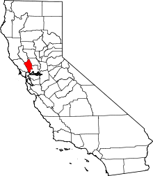
 Pope Valley, California Location within the state of California | |
| Coordinates: 38°37′8″N 122°26′8″W / 38.61889°N 122.43556°WCoordinates: 38°37′8″N 122°26′8″W / 38.61889°N 122.43556°W | |
| Country |
|
| State |
|
| County | Napa |
| Elevation | 715 ft (218 m) |
| Time zone | Pacific (PST) (UTC-8) |
| • Summer (DST) | PDT (UTC-7) |
| ZIP codes | 94567 |
| Area code(s) | 707 |
| GNIS feature ID | 230940[1] |
Pope Valley is an unincorporated community located in the small valley of the same name in the Mayacamas Mountains and northern Napa County, California.
It is east of Calistoga, north of Angwin, and borders Lake Berryessa, the second largest man-made lake in California. The zip code for Pope Valley is 94567, and the area code 707.
History
Pope Valley is the home of Aetna Springs Resort, a Registered Historic Place. Pope Valley was named after William (Julian) Pope who was granted property in Rancho Locoallomi in 1841 by acting Governor Manuel Jimeno.[2]
On the afternoon of July 1, 2014, a large wildfire started in the Butts Canyon area and eventually burned 4300 acres.[3][4]
Geography
As of 1881, limestone was being mined in the northern part of Pope Valley.[5]
Demographics
Pope Valley has a population of 583 people, with 6.5 people per square mile. There are 304 males and 279 females residing in Pope Valley and the median age is 43.[6]
Government
In the California State Legislature, Pope Valley is in the 3rd Senate District, represented by Democrat Bill Dodd, and in the 4th Assembly District, represented by Democrat Cecilia Aguiar-Curry.[7]
In the United States House of Representatives, Pope Valley is in California's 5th congressional district, represented by Democrat Mike Thompson.[8]
References
- ↑ "Pope Valley, California". Geographic Names Information System. United States Geological Survey.
- ↑ Durham, David L. (1998). California's Geographic Names: A Gazetteer of Historic and Modern Names of the State. Clovis, Calif.: Word Dancer Press. p. 684. ISBN 1-884995-14-4.
- ↑ "Fire In Napa County Burns Nearly 3,200 Acres, Mandatory Evacuations Continue". Local. CBS. KPIX. July 1, 2014. Retrieved 29 August 2014.
- ↑ "Butts Canyon Fire more under control; remains at 4,300 acres". Napa Valley Register. Napa, CA: Lee Enterprises, Inc. July 4, 2014. Retrieved August 29, 2014.
- ↑ History of Napa and Lake Counties, California: Comprising Their Geography, Geology, Topography, Climatography, Springs and Timber ... Slocum, Bowen & Company. 1881. p. 29.
- ↑ "Pope Valley, CA 94567 Population Growth and Population Statistics". CLRChoice, Inc. Retrieved 10 December 2012.
- ↑ "Statewide Database". UC Regents. Retrieved December 6, 2014.
- ↑ "California's 5th Congressional District - Representatives & District Map". Civic Impulse, LLC. Retrieved March 3, 2013.
| Bodies of water |
|  |
|---|---|---|
| Counties | ||
| Major cities | ||
| Cities and towns 100k–250k | ||
| Cities and towns 50k–99k | ||
| Cities and towns 25k-50k | ||
| Cities and towns 10k–25k |
| |
| Sub-regions | ||