Pontcysyllte Aqueduct
| Pontcysyllte Aqueduct | |
|---|---|
|
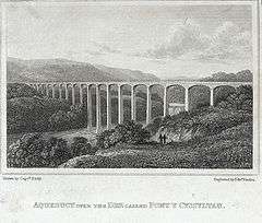
(1823 engraving) | |
| Coordinates | 52°58′14″N 3°05′16″W / 52.97053°N 3.08783°WCoordinates: 52°58′14″N 3°05′16″W / 52.97053°N 3.08783°W |
| OS grid reference | |
| Carries | Llangollen Canal |
| Crosses | River Dee |
| Locale | Froncysyllte |
| Maintained by | Canal & River Trust |
| Heritage status | Grade 1 |
| Characteristics | |
| Trough construction | Cast iron |
| Pier construction | Stone |
| Total length | 336 yards (307 m) |
| Width | 4 yards (3.4 m) |
| Height | 126 feet (38 m) |
| Traversable? | Yes |
| Towpaths | East side |
| Number of spans | Eighteen |
| Piers in water | Four |
| History | |
| Designer | Thomas Telford |
| Opened | 1805 |
| Pontcysyllte Aqueduct and Canal | |
|---|---|
| Name as inscribed on the World Heritage List | |
|
The aqueduct | |
| Type | Cultural |
| Criteria | i, ii, iv |
| Reference | 1303 |
| UNESCO region | Europe and North America |
| Inscription history | |
| Inscription | 2009 (33rd Session) |

The Pontcysyllte Aqueduct (Welsh pronunciation: [ˌpɔntkəˈsəɬtɛ], full name in Welsh: Traphont Ddŵr Pontcysyllte) is a navigable aqueduct that carries the Llangollen Canal over the valley of the River Dee in Wrexham County Borough in north east Wales. Completed in 1805, it is the longest and highest aqueduct in Great Britain, a Grade I Listed Building[1] and a World Heritage Site. The viaduct carries a water passage for a single canal narrow boat as well as a towpath for pedestrians, and is now a popular tourist excursion; boat trips cross the viaduct and return.
When the bridge was built, it linked the villages of Froncysyllte, at the southern end of the bridge in the Cysyllte township of Llangollen parish (from where it takes its name[2]), and Trevor (Trefor in Welsh), at the northern end of the bridge in the Trefor Isaf township, also of Llangollen parish. Both townships were later transferred to Wrexham County Borough following local government reorganisation.
The name Pontcysyllte is in the Welsh language and means "Cysyllte Bridge".[2] The township of Cysyllte existed for centuries before the bridge was built. For most of its history, the aqueduct was known as Pont y Cysyllte ("Bridge of Cysyllte"). Other translations such as "Bridge of the Junction" or "The Bridge that links" are modern, and incorrect, derived from the literal English translation of cysyllte as "junctions" or "links."
History
The aqueduct, built by Thomas Telford and William Jessop, is 336 yd (307 m) long, 4 yd (3.7 m) wide and 5.25 ft (1.60 m) deep. It consists of a cast iron trough supported 126 ft (38 m) above the river on iron arched ribs carried on eighteen hollow masonry piers (pillars). Each of the nineteen spans is 53 ft (16 m) wide. Despite considerable public scepticism, Telford was confident the construction method would work: he had previously built at least one cast-iron trough aqueduct – the Longdon-on-Tern aqueduct on the Shrewsbury Canal. It is still visible in the middle of a field, though the canal was abandoned years ago.
Part of what was originally called the Ellesmere Canal, the Pontcysyllte aqueduct was one of the first major feats of civil engineering undertaken by Telford, by then a leading civil engineer, supervised by Jessop, the more experienced canal engineer. The iron was supplied by William Hazledine from his foundries at Shrewsbury and nearby Cefn Mawr. It was opened on 26 November 1805, having taken around ten years to design and build at a total cost of £47,000. Adjusted for inflation this is equivalent to no more than £3,440,000 in 2015[3], but represented a major investment against the contemporary GDP of some £400 million.[4] Such a project would cost more today due to factors that did not apply in the early 19th century, such as higher real wages, safety measures, new regulations and taxes, financing fees and so on.
At the time of the aqueduct's completion, the canal terminated at a wharf slightly to its north. A feeder to bring water from the Horseshoe Falls beyond Llangollen was completed three years later in 1808. At some point after 1820, the Plas Kynaston Canal was built to serve industry in the Cefn Mawr and Rhosymedre areas. There might have been another canal extension ("Ward's") but detailed records do not survive.[5]
Structure

The mortar used lime, water and ox blood.[6] The iron castings for the trough were produced at the nearby Plas Kynaston Foundry, Cefn Mawr, which was built by the Shrewsbury ironfounder and millwright William Hazledine in the hope of gaining the contract. The rib castings may have been made at Hazledine's original works at Coleham, near Shrewsbury.[7] The trough was made from flanged plates of cast iron, bolted together, with the joints bedded with Welsh flannel and a mixture of white lead and iron particles from boring waste.[8] After twenty-five years the white lead was replaced with ordinary tar.[9][10] As with Telford's Longdon-on-Tern aqueduct, the plates are not rectangular but shaped as voussoirs, similar to those of a stone arch. There is no structural significance to their shape: it is a decorative feature only, following the lines of the stiffening plates (see below) in the castings beneath.[8]
The supporting arches, four for each span, are in the form of cast-iron ribs, each cast as three voussoirs with external arches cast with an un-pierced web to give greater strength, at the cost of extra weight. Using cast iron in this way, in the same manner as the stone arch it supersedes, makes use of the material's strength in compression.[11] They also give an impression of greater solidity than would be the case were the webs pierced. This impression is enhanced by the arrangement of strips of thicker stiffening incorporated into the castings, arranged in the manner of joints between voussoirs.
Cast plates are laid transversely to form the bed of the canal trough. The trough is not fastened to the arches, but lugs are cast into the plates to fit over the rib arches to prevent movement.[8] The aqueduct was left for six months with water inside to check that it was watertight.[12] A feature of a canal aqueduct, in contrast with a road or railway viaduct, is that the vertical loading stresses are virtually constant. According to Archimedes' principle, the mass (weight) of a boat and its cargo on the bridge pushes an equal mass of water off the bridge.
The towpath is mounted above the water, with the inner edge carried on cast-iron pillars in the trough. This arrangement allows the water displaced by the passage of a narrow boat to flow easily under the towpath and around the boat, enabling relatively free passage. Pedestrians, and the horses once used for towing, are protected from falling from the aqueduct by railings on the outside edge of the towpath, but the holes in the top flange of the other side of the trough, capable of mounting railings, were never used. The trough sides rise only about 6 inches (15 cm) above the water level, less than the depth of freeboard of an empty narrow boat, so the helmsman of the boat has no visual protection from the impression of being at the edge of an abyss. The trough of the Cosgrove aqueduct has a similar structure, although it rests on trestles rather than iron arches. It is also less impressively high.
Every five years the ends of the aqueduct are closed and a plug in one of the highest spans is opened to drain the canal water into the River Dee below, to allow inspection and maintenance of the trough.[13][14]
The canal effectively ends after a short distance on the north side, apart from a feeder to the Horseshoe Falls on the River Dee via Llangollen. The terrain northwards appears to have been the main problem in preventing significant further extension: apart from one or more local spurs of perhaps a thousand yards serving industry south of Cefn Mawr and towards Rhosymedre, [5] other traffic was handled by the Ruabon Brook Tramway which climbed towards Acrefair and Plas Bennion. This railway was eventually upgraded to steam operation and extended towards Rhosllannerchrugog and Wrexham.
World Heritage Site
The aqueduct and surrounding lands were submitted to the "tentative list" of properties being considered for UNESCO World Heritage Site status in 1999.[15] The aqueduct was suggested as a contender in 2005—its 200th anniversary year[16]—and it was formally announced in 2006 that a larger proposal, covering a section of the canal from the aqueduct to Horseshoe Falls would be the United Kingdom's 2008 nomination.[17][18]
The length of canal from Rhoswiel, Shropshire, to the Horseshoe Falls, including the main Pontcysyllte Aqueduct structure as well as the older Chirk Aqueduct, were visited by assessors from UNESCO during October 2008, to analyse and confirm the site management and authenticity. The aqueduct was inscribed by UNESCO on the World Heritage List on 27 June 2009.[19]
Wildlife
In March 2010 it was reported that the site had attracted a thriving community of otters.[20]
Gallery
 A canal boat crossing the aqueduct. Note the shape of the iron plates, cast to give the impression of traditional stone voussoirs (2008)
 A view of the Dee Valley from the aqueduct
 From the river and valley
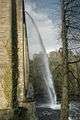 The canal being drained for inspection and maintenance (2009)
See also
- Canals of the United Kingdom
- List of canal aqueducts in Great Britain
- List of bridges in Wales
- List of Scheduled Monuments in Wrexham
References
- ↑ "Listed Buildings: Pontcysyllte Aqueduct, Trevor", Wrexham County Borough Council, viewed on 25 May 2007
- 1 2 Owen, Hywel Wyn (2007). A Dictionary of Place-Names in Wales. Ceredigion, Wales: Gomer Press. ISBN 978-1-84323-901-7.
- ↑ UK CPI inflation numbers based on data available from Gregory Clark (2016), "The Annual RPI and Average Earnings for Britain, 1209 to Present (New Series)" MeasuringWorth.
- ↑
- 1 2 Plas Kynaston Canal by P Brown
- ↑ "Aqueducts", waterscape.com
- ↑ Quenby, Ron (1992). Thomas Telford's Aqueducts. Shrewsbury: Swan Hill Press. p. 63. ISBN 1-85310-246-6.
- 1 2 3 "The Pontcysyllte Aqueduct". The Royal Commission on the Ancient and Historical Monuments of Wales. February 2009. Retrieved 5 June 2009.
- ↑ Burton, Anthony (2015). "The Shropshire Surveyor". Thomas Telford: Master Builder of Roads and Canals. ISBN 9781473864085.
- ↑ Pattison, Andrew (October 2011). William Hazledine, Shropshire ironmaster and millwright: a reconstruction of his life, and his contribution to the development of engineering, 1780 - 1840 (PDF) (Ph.D.). University of Birmingham. p. 105. Retrieved 9 August 2016.
- ↑ Hopkins, Henry James (1970). A Span of Bridges: An Illustrated History. Newton Abbot, England: David & Charles. ISBN 0-7153-4804-3.
- ↑ www.transportheritage.com Pontcysyllte
- ↑ "Plug pulled on historic aqueduct". BBC News Online. 20 January 1998. Retrieved 25 November 2008.
At midday on Tuesday, they pulled the plug and 1.5 million litres of water, enough to fill 8,000 baths, cascaded to the River Dee below.
- ↑ "Birthday clean for aqueduct". BBC News Online. 16 November 2003. Retrieved 25 November 2008.
next Monday and Tuesday all 12,000 cubic metres - around 12,000 bath tubs - of water will be completely drained away.
- ↑ "Pont-Cysyllte Aqueduct". Tentative Lists Database. UNESCO. 29 June 1999. Retrieved 25 November 2008.
Pont-Cysyllte Aqueduct; Date of Submission: 21 June 1999; Criteria: (i)(ii)(iv); Category: Cultural
- ↑ "Aqueduct's big bicentenary party". BBC News Online. 27 November 2005.
- ↑ "Aqueduct set for heritage status". BBC News Online. 10 October 2006.
- ↑ "Pontcysyllte Aqueduct And Canal - 'Magnificent Masterpiece Of The Canal Age' - To Be UK's Next Bid For World Heritage Status". Department for Culture, Media and Sport. 11 January 2008. Retrieved 25 November 2008.
It consists of 11 miles (18 kilometres) of continuous waterway, from Horseshoe Falls near Llangollen to Gledrid Bridge near Rhoswiel
- ↑ "Aqueduct crowned 'world wonder'". BBC News Online. 27 June 2009.
- ↑ Aqueduct attracts otters with a taste for the high life at walesonline.co.uk
Further reading
- Memories of Pontcysyllte by Amy Douglas and Fiona Collins (2006)
- Pontcysyllte Aqueduct and Canal Nomination as a World Heritage Site: Nomination Document (Wrexham County Borough Council and the Royal Commission on the Ancient and Historical Monuments of Wales, 2008)
External links
| Wikimedia Commons has media related to Pontcysyllte Aqueduct. |
- The Pontcysyllte Aqueduct website
- 360 Degree panoramic view at BBC Shropshire (Java Applet Required)
- Aerial photo at Windows Live Local
- Wrexham on-line tour: Pontcysyllte Aqueduct
- Construction visualisation video
- Articles on the construction of the Pontcysyllte Aqueduct from the Royal Commission on Ancient and Historical Monuments of Wales
- Management plan for the nomination as a World Heritage Site. Includes detailed description on the scope of the World Heritage site which starts at Rhoswiel and goes through to the Horseshoe Falls
| Principal settlements |  | |
|---|---|---|
| Communities |
| |
| Other villages and areas |
| |
| Castles | ||
| Buildings and structures | ||
| Rivers | ||
| Geographical features | ||
| Topics | ||