Podnanos
| Podnanos Šent Vid (until 1952), Šembid (local) | |
|---|---|
 | |
 Podnanos Location in Slovenia | |
| Coordinates: 45°47′50.11″N 13°58′18.4″E / 45.7972528°N 13.971778°ECoordinates: 45°47′50.11″N 13°58′18.4″E / 45.7972528°N 13.971778°E | |
| Country |
|
| Traditional region | Littoral |
| Statistical region | Gorizia |
| Municipality | Vipava |
| Area | |
| • Total | 1.36 km2 (0.53 sq mi) |
| Elevation | 169.2 m (555.1 ft) |
| Population (2002) | |
| • Total | 364 |
| [1] | |
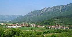
Podnanos (pronounced [pɔˈdnaːnɔs]; Italian: San Vito di Vipacco) is a village in the upper Vipava Valley in the Municipality of Vipava in the Littoral region of Slovenia. It lies below Mount Nanos, from which it gets its current name.[2]
Name
The name of the settlement was changed from Šent Vid (literally, 'Saint Vitus') to Podnanos (literally, 'below Mount Nanos') in 1952. The name was changed on the basis of the 1948 Law on Names of Settlements and Designations of Squares, Streets, and Buildings as part of efforts by Slovenia's postwar communist government to remove religious elements from toponyms. The local name of the settlement, Šembid,[3] is derived from Šent Vid.[4][5][6]
Church
The parish church in the settlement is dedicated to Saint Vitus and belongs to the Koper Diocese.[7]
Notable residents
- Stanko Premrl (1880–1965), priest and composer of the national anthem of Slovenia
- Janko Premrl (a.k.a. Vojko) (1920–1943), anti-fascist resistance fighter and organizer of the Slovenian partisan movement in the Slovenian Littoral
References
- ↑ Statistical Office of the Republic of Slovenia
- ↑ Vipava municipal site
- ↑ Premrl, Radoslava. 1992. Moj brat Janko - Vojko. Ljubljana: Slovenska matica, p. 5.
- ↑ Spremembe naselij 1948–95. 1996. Database. Ljubljana: Geografski inštitut ZRC SAZU, DZS.
- ↑ Premk, F. 2004. Slovenska versko-krščanska terminologija v zemljepisnih imenih in spremembe za čas 1921–1967/68. Besedoslovne lastnosti slovenskega jezika: slovenska zemljepisna imena. Ljubljana: Slavistično društvo Slovenije, pp. 113–132.
- ↑ Urbanc, Mimi, & Matej Gabrovec. 2005. Krajevna imena: poligon za dokazovanje moči in odraz lokalne identitete. Geografski vestnik 77(2): 25–43.
- ↑ Koper Diocese list of churches
External links
| Wikimedia Commons has media related to Podnanos. |
- Podnanos Homepage - Tourist information center
- Podnanos at Geopedia (maps, aerial photographs)
- Podnanos on Google Maps (maps, photographs, street view)
| Settlements |  | |
|---|---|---|
| Landmarks |
| |
| Notable people |
| |