Plotter Kill Preserve
| Plotter Kill Nature Reserve | |
|---|---|
|
Trail entrance sign | |
| Length | 3 miles circular (4 miles total) |
| Location | Rotterdam (town), New York, USA |
| Use | Recreation and Natural History |
| Hiking details | |
| Trail difficulty | Easy |
| Season | All year round |
| Sights | Variety of birds and other wildlife |
| Hazards | High unstable cliff edges |

The Almy D. Coggleshall Plotter Kill Preserve is a 632-acre (2.56 km2) nature reserve and hiking area located on Route 159 in the town of Rotterdam, Schenectady County, New York State.
Etymology
Plotter kill is most likely a corruption of Platte kill, which is also found in Ulster County. The Platte comes from the Dutch Het Platte, a term applied to country districts, and kill meaning stream or creek.[1]
General description
The preserve is named after Almy D. Coggleshall, who was central in creating the trail at Plotter Kill while a member of the Schenectady County Environmental Advisory Council. In 1990 the preserve was renamed in his honor.[2] While the preserve is a forest containing a mixture of hardwood and conifers, its main feature is the Plotter Kill gorge. The gorge was cut by melt waters at the close of the ice ages approximately 10,000 years ago. The Plotter Kill is a tributary of the Mohawk River which runs for 3.5 miles (5.6 km) from Rynex Corner dropping 900 feet (270 m) to the river. There are three waterfalls in the preserve, the Upper, the Lower and the Rynex Creek Falls. The Upper has a 60-foot (18 m) drop while the Lower and Rynex Creek falls each have drops of 40 feet (12 m).[3]
Natural history
Many of the flat rock layers, exposed by water flow and erosion over the last 20,000 years, were originally formed during the Mohawkian age of the Ordovician period, approximately 450 million years ago. These layers appear rectangular, featuring orthogonal joint sets.
The Plotter Kill Preserve is ideal for nature study and is used by local schools and Boy Scout troops. The preserve is a mixture of native hardwoods and conifers including several species of pine, oak, birch and maple. Over 600 species of plants have been found in the area including: trilliums, violets, lilies, ferns and club mosses. There is also an abundance of both animal and bird life, with garter snakes, chipmunks and amphibians such as frogs and salamanders often seen.[3] There are also an undocumented number of different species of toad stools and other varieties of fungi.
In literature
The falls are mentioned in the journals of Samson Occam Mohegan (1723 - 1792). The entry for Wednesday 29 November 1786 reads "Some time after breakfast Mr Henry Fero and I went to see the falls and it is a grand sight, the power of God is to be seen here." [4]
 Sign in the Parking Lot of the Copland Road entrance.
 View of the Upper Falls
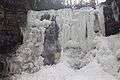 View of Upper Falls in winter
 View of the Upper Falls from the Blue Trail
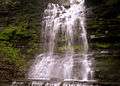 View of Second Fall during the Summer.
 View of the renovated trail in 2010.
The trailhead
The trailhead and general access is located on Mariaville Road (route 159). To reach it leave Interstate I890 at exit 2A (Campbell Road) and follow the signs for Rotterdam Square Mall. Opposite the mall entrance turn right on to Putnam Road and then turn right on reaching Route 159 after approximately 2 miles (3.2 km). The parking area for the preserve is located on the right approximately 2 miles (3.2 km) after turning onto Route 159.
References
- ↑ New York State Museum (1913). Museum Bulletin. 173: 57. Missing or empty
|title=(help) - ↑ "An Early advocate for Adirondacks dead at age 91". Schenectady Gazette. 2009-01-06.
- 1 2 "Schenectady County web site". Retrieved 2009-07-14.
- ↑ Occom, Samson (May 2006). Joanna Brooks, ed. The Collected Writings of Samson Occom, Mohegan: Literature and Leadership in Eighteenth-Century Native America. Oxford University Press. p. 350. ISBN 0-19-517083-0.
External links
Coordinates: 42°49′47″N 74°02′12″W / 42.8297°N 74.0367°W