Pleasant Valley, Monmouth County, New Jersey
For other places with similar names, see Pleasant Valley, New Jersey.
| Pleasant Valley, New Jersey | |
|---|---|
| Unincorporated community | |
|
Intersection of Pleasant Valley Road and Reids Hill Road | |
 Pleasant Valley, New Jersey 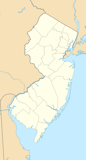 Pleasant Valley, New Jersey  Pleasant Valley, New Jersey Location of Pleasant Valley in Monmouth County Inset: Location of county within the state of New Jersey | |
| Coordinates: 40°22′00″N 74°12′47″W / 40.36667°N 74.21306°WCoordinates: 40°22′00″N 74°12′47″W / 40.36667°N 74.21306°W | |
| Country |
|
| State |
|
| County | Monmouth |
| Township | Marlboro |
| Elevation[1] | 197 ft (60 m) |
| GNIS feature ID | 879364[1] |

Pleasant Valley is an unincorporated community located within Marlboro Township in Monmouth County, New Jersey, United States.[2] The area is hilly and forested and is dotted by medium to large-sized residences. Pleasant Valley Road and Reids Hill Road are main roads that pass through the area connecting to Routes 34, 79, and 520.[3]
References
- 1 2 "Pleasant Valley". Geographic Names Information System. United States Geological Survey.
- ↑ Locality Search, State of New Jersey. Accessed February 28, 2015.
- ↑ Google (April 19, 2015). "Aerial view of Pleasant Valley" (Map). Google Maps. Google. Retrieved April 19, 2015.
This article is issued from Wikipedia - version of the 6/9/2016. The text is available under the Creative Commons Attribution/Share Alike but additional terms may apply for the media files.