Pleasant Hill/Contra Costa Centre station
Pleasant Hill Contra Costa Centre | |||||||||||
|---|---|---|---|---|---|---|---|---|---|---|---|
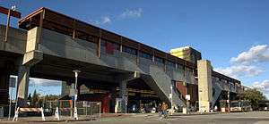 The front entrance of the Pleasant Hill BART Station | |||||||||||
| Location |
1365 Treat Boulevard Walnut Creek, CA 94597 | ||||||||||
| Line(s) | |||||||||||
| Platforms | 2 Side platforms | ||||||||||
| Construction | |||||||||||
| Parking | 3011 spaces- Monthly Reserved, Daily ($3/day), Extended Weekend (free), Midday (free after 3pm), Carpool, Long Term, Professional Assisted Parking[1] | ||||||||||
| Bicycle facilities | 90 Lockers | ||||||||||
| Disabled access | Yes | ||||||||||
| History | |||||||||||
| Opened | May 21, 1973 (44 Years Ago) | ||||||||||
| Traffic | |||||||||||
| Passengers (FY 2013) |
6,579 exits/day[2] | ||||||||||
| Services | |||||||||||
| |||||||||||
Pleasant Hill/Contra Costa Centre is a Bay Area Rapid Transit station serving the Contra Costa Centre Transit Village in Contra Costa Centre, California, just north of Walnut Creek and just east of Pleasant Hill.
Station layout
| P Platform level |
Side platform, doors will open on the right | |
| Southbound | ← Pittsburg/Bay Point–SFO/Millbrae toward San Francisco International Airport weekdays, Millbrae weekends (Walnut Creek) | |
| Northbound | → Pittsburg/Bay Point–SFO/Millbrae toward Pittsburg / Bay Point (Concord) → | |
| Side platform, doors will open on the right | ||
| G | Street Level | Exits/Entrances |
| Mezzanine | One-way faregates, ticket machines, station agent | |
The station consists of two elevated side platforms.
Service at this station began on May 21, 1973.[3]
This station is in BART District 1 and is represented by Gail Murray.[4]
A new parking garage opened at the station with 1,547 spaces on June 30, 2008.[5] The former station parking lot was converted into the Contra Costa Centre transit village.
An improved access path to the station better connecting it with the Iron Horse Regional Trail was proposed before the Walnut Creek city council on July 15, 2008.[6] The proposal gained support from BART and the local cycling organization.[6] A bridge over Treat Boulevard carrying the Iron Horse Regional Trail was completed on October 2, 2010.[7] The bridge cost $12 million.[8]
Despite opposition from the Pleasant Hill City Council, on October 11, 2010, the BART Board of Directors approved the station name change from "Pleasant Hill" to "Pleasant Hill/Contra Costa Centre" because of the station's proximity to the transit village.[9] The Contra Costa County Redevelopment Agency and AvalonBay Communities will cover the cost of changing the station signage as part of a planned $3 million upgrade.[10][11]
Transit connections
Several local area County Connection service bus lines stop at the station: (Monday-Friday) Weekdays only:
- 7
- 9
- 11
- 14
- 15
- 18
(Saturday-Sunday) Weekends only:
- 311
- 316
- 40
- 78
- 80s (Sundays Only)
- 70X
See also
References
- ↑ http://www.bart.gov/stations/phil/index.aspx#parking
- ↑ "BART Fiscal Year Weekday Average Exits" (PDF). Bay Area Rapid Transit (BART). Retrieved 28 July 2014.
- ↑ BART History
- ↑ Bay Area Rapid Transit District Biography, BART.gov, retrieved June 8, 2013
- ↑ New Garage at Pleasant Hill Station, BART News, June 20, 2008, access date August 18, 2008
- 1 2 Pleasant Hill BART Station bike/pedestrian shortcut considered, BART News, July 8, 2008, accessed August 18, 2008
- ↑ East Bay Bicycle Coalition (25 September 2010). "Time to Celebrate! Bike/Ped Bridge over Treat Blvd Opens October 2". East Bay Bicycle Coalition. Retrieved 8 July 2013.
- ↑ Hambrick, Ken (Guest Commentary) (21 August 2010). "Your Turn: Treat Boulevard bridge to nowhere exposes what is wrong with redevelopment". Contra Costa Times. Retrieved 8 July 2013.
- ↑ 511 Contra Costa. "Pleasant Hill BART Station Will Undergo Name Change". 511 Contra Costa. Retrieved 8 July 2013.
- ↑ "Pleasant Hill BART station now 'Pleasant Hill/Contra Costa Centre'". Trading Markets.com via Contra Costa Times. Retrieved 23 December 2010.
- ↑ "East Contra Costa BART Extension (eBART)". Bay Area Rapid Transit (BART). Retrieved 24 December 2010.
External links
| Wikimedia Commons has media related to Pleasant Hill BART station. |
- BART - Pleasant Hill Station Overview
- CCReach - Pleasant Hill BART Overview
- The Pleasant Hill BART Station Design Charrette
- Virtual Tour of the Transit Village Construction Site
Coordinates: 37°55′42″N 122°03′22″W / 37.928399°N 122.055992°W