Pierrepont, New York
| Pierrepont, New York | |
|---|---|
| Town | |
 Pierrepont, New York Location within the state of New York | |
| Coordinates: 44°32′53″N 75°0′44″W / 44.54806°N 75.01222°W | |
| Country | United States |
| State | New York |
| County | St. Lawrence |
| Area | |
| • Total | 60.7 sq mi (157.3 km2) |
| • Land | 60.4 sq mi (156.4 km2) |
| • Water | 0.3 sq mi (0.8 km2) |
| Elevation | 922 ft (281 m) |
| Population (2010) | |
| • Total | 2,589 |
| Time zone | Eastern (EST) (UTC-5) |
| • Summer (DST) | EDT (UTC-4) |
| FIPS code | 36-57771 |
| GNIS feature ID | 0979365 |
| Website | Official Town of Pierrepont official website |
- For Pierrepont Manor, New York, see Jefferson County, New York
Pierrepont is a town and hamlet in St. Lawrence County, New York, in the United States. As of the 2010 census, the town population was 2,589. It was named after Hezekiah Pierrepont, the early owner of much of the town's territory. The Town of Pierrepont is centrally located in the county and is southeast of Canton. A hamlet of the same name is in the town of Pierrepont. Pierrepont Manor, however, is located in Jefferson County.
History
The first European-American settlers arrived around 1806/7, after the American Revolutionary War, when many settlers from New England migrated into upstate New York.[1] The town was established in 1818 from parts of the Towns of Russell and Potsdam. Later the town gave up territory to form, in whole or part, the Towns of Fine (1844), Clifton (1868), and Clare (1882).
Geography
According to the United States Census Bureau, the town has a total area of 60.7 square miles (157 km2), of which, 60.4 square miles (156 km2) of it is land and 0.3 square miles (0.78 km2) of it (0.51%) is water.
The Raquette River, which is the longest river in St. Lawrence County and the third longest in New York state, flows through the northeast part of the town.
New York State Route 56 crosses the northeast part of Pierrepont, and New York State Route 68 is an east-west highway.
Notable people
- Marnie Reed Crowell, writer, ecologist
- Edwin Atkins Merritt, member of the New York State Assembly, Quartermaster General of the New York Militia, Collector of the Port of New York
- Edwin Albert Merritt, U.S. Congressman
Demographics
| Historical population | |||
|---|---|---|---|
| Census | Pop. | %± | |
| 1820 | 235 | — | |
| 1830 | 749 | 218.7% | |
| 1840 | 1,430 | 90.9% | |
| 1850 | 1,459 | 2.0% | |
| 1860 | 2,267 | 55.4% | |
| 1870 | 2,391 | 5.5% | |
| 1880 | 2,494 | 4.3% | |
| 1890 | 1,954 | −21.7% | |
| 1900 | 1,885 | −3.5% | |
| 1910 | 1,628 | −13.6% | |
| 1920 | 1,425 | −12.5% | |
| 1930 | 1,379 | −3.2% | |
| 1940 | 1,312 | −4.9% | |
| 1950 | 1,192 | −9.1% | |
| 1960 | 1,523 | 27.8% | |
| 1970 | 1,726 | 13.3% | |
| 1980 | 2,207 | 27.9% | |
| 1990 | 2,375 | 7.6% | |
| 2000 | 2,674 | 12.6% | |
| 2010 | 2,589 | −3.2% | |
| Est. 2014 | 2,578 | [2] | −0.4% |
As of the census[4] of 2000, there were 2,674 people, 1,039 households, and 744 families residing in the town. The population density was 44.3 people per square mile (17.1/km²). There were 1,233 housing units at an average density of 20.4 per square mile (7.9/km²). The racial makeup of the town was 98.77% White, 0.19% African American, 0.15% Native American, 0.52% Asian, and 0.37% from two or more races. Hispanic or Latino of any race were 0.30% of the population.
There were 1,039 households out of which 33.9% had children under the age of 18 living with them, 61.2% were married couples living together, 6.5% had a female householder with no husband present, and 28.3% were non-families. 21.0% of all households were made up of individuals and 7.5% had someone living alone who was 65 years of age or older. The average household size was 2.57 and the average family size was 2.99.
In the town the population was spread out with 25.9% under the age of 18, 6.5% from 18 to 24, 29.6% from 25 to 44, 27.6% from 45 to 64, and 10.4% who were 65 years of age or older. The median age was 38 years. For every 100 females there were 106.3 males. For every 100 females age 18 and over, there were 100.3 males.
The median income for a household in the town was $41,890, and the median income for a family was $44,500. Males had a median income of $36,398 versus $23,438 for females. The per capita income for the town was $19,239. About 7.3% of families and 11.5% of the population were below the poverty line, including 13.1% of those under age 18 and 5.6% of those age 65 or over.
Communities and locations in Pierrepont
- Austin's Corners – a location by the south town line.
- Brown's Bridge – a location in the northeast part of the town at the Raquette River. Called Browns Bridge, the steel deck bridge is actually green and is a popular spot for swimming; a dam and penstock are located at Browns Bridge. County Route 24, also known as the Russell Turnpike Road, goes through Brown's Bridge.
- Coney Island – a dead-end roadway in Hannawa Falls located on the Raquette River, which was a small amusement park from the 1920s through the 1940s.
- Crary Mills: a hamlet in the northwest part of the town at the town line. Crary Mills is located on the town lies of Pierrepont, Colton and Canton; County Route 35 goes through the hamlet. The Crary Mills Mighty Mall houses small specialty shops.
- Dean's Corners – a location in the southwest part of Pierrepont.
- Hannawa Falls – a hamlet in the eastern part of the town on NY-56. The community was previously called "Cox's Mill", "East Pierrepont", and "Ellsworth". As of 2012, Hannawa Falls has two convenience stores (Chip's Place and the Country Store), a post office (ZIP 13647), a volunteer fire department, two bars, and community park and beach (Postwood Park and the 4-H plantation). Potsdam Central School District absorbed the school in the 1970s. Children today attend Potsdam Central Schools. State Route 56 travels through the hamlet with County Routes 59 and 24 bordering the hamlet. The Gardner Cox House was listed on the National Register of Historic Places in 1986.[5]
- Moore's Corners – a location in the southwest part of the town.
- Pierrepont is on NY-68 at County Road 24. The town hall and museum are located here; Pierrepont has its own fire department. The Pierrepont Town Buildings was listed on the National Register of Historic Places in 1982.[5]
- Selleck's Corners – a location in the southeast part of Pierrepont.
- Vebber Corners – a location in the southeast part of the town south of Washburn Corners.
- Washburn Corners – a location in the eastern part of the town.
- West Pierrepont – a hamlet in the southwest part of the town.
- Willisville – a location in the eastern part of Pierrepont.
- Wilson Corners – a location in the south part of the town south of Washburn Corners.
- Postwood and 4-H – a popular place to swim, Postwood Park is a small beach located on the Raquette River. In the mid part of the 20th century, Postwood had camping grounds. Next to Postwood is a large tract of county-owned land known as 4-H, which was once a popular spot for local 4-H troops.
References
- ↑ "Pierrepont History", OUR COUNTY AND ITS PEOPLE: A MEMORIAL RECORD OF ST. LAWRENCE COUNTY, NEW YORK, edited by GATES CURTIS, Boston: The Boston History Company, 1894
- ↑ "Annual Estimates of the Resident Population for Incorporated Places: April 1, 2010 to July 1, 2014". Retrieved June 4, 2015.
- ↑ "Census of Population and Housing". Census.gov. Retrieved June 4, 2015.
- ↑ "American FactFinder". United States Census Bureau. Retrieved 2008-01-31.
- 1 2 National Park Service (2009-03-13). "National Register Information System". National Register of Historic Places. National Park Service.
External links
Coordinates: 44°32′32″N 75°00′43″W / 44.54222°N 75.01194°W
Municipalities and communities of St. Lawrence County, New York, United States | ||
|---|---|---|
| City | 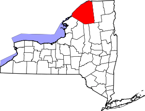 | |
| Towns | ||
| Villages | ||
| CDPs |
| |
| Hamlets | ||