Pico da Neblina National Park
| Pico da Neblina National Park | |
|---|---|
|
IUCN category II (national park) | |
 | |
 | |
| Location | State of Amazonas, Northern Brazil |
| Nearest city | São Gabriel da Cachoeira |
| Area | 22,200 km² |
| Designation | National park |
| Established | 1979 |
| Governing body | Brazilian Institute of Environment and Renewable Natural Resources (IBAMA) |
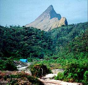
Pico da Neblina National Park is a national park in the north of Brazil, bordering on Venezuela.
Location
The Pico da Neblina National Park was created in 1979, and it is one of the country's largest national parks, with 22,200 km2 (8,600 sq mi). The park was named after Pico da Neblina, one of its mountains and the country's highest elevation at 2,994 m (9,823 ft). It is covered by dense or open Amazon Rainforest, although other forms of vegetation, associated to high altitudes, can be also found in the area. The wildlife is very diverse, with some peculiar species, like the Neblina uakari and the Guianan cock-of-the-rock. Venezuela has an adjoining national park, called Neblina as well.
Pico da Neblina National Park is located in one of the wettest areas of the Amazon, with an annual precipitation of 4,000 mm (160 in). The park is also part of the Yanomami territory and requires a special permit to be visited. There is no tourist infrastructure whatsoever and access is very difficult.
The conservation unit would be included in the proposed Northern Amazon Ecological Corridor.[1]
References
- ↑ Ayres et al. 2005, p. 31.
Sources
- Ayres, José Márcio; Da Fonseca, Gustavo A. B.; Rylands, Anthony B.; Queiroz, Helder L.; Pinto, Luiz Paulo; Masterson, Donald; Cavalcanti, Roberto B. (2005), Os Corredores Ecológicos das Florestas Tropicais do Brasil (PDF) (in Portuguese), Sociedade Civil Mamirauá, retrieved 2016-10-28
Coordinates: 0°20′33″N 65°54′02″W / 0.342409°N 65.9006°W