Pickerington, Ohio
| Pickerington, Ohio | ||
|---|---|---|
| City | ||
|
The welcome sign located on Hill Road | ||
| ||
| Nickname(s): Picktown, Violet Capital of Ohio, The Purple City | ||
 Location of Pickerington, Ohio | ||
 Location of Pickerington in Fairfield County | ||
| Coordinates: 39°53′32″N 82°45′50″W / 39.89222°N 82.76389°WCoordinates: 39°53′32″N 82°45′50″W / 39.89222°N 82.76389°W | ||
| Country |
| |
| State |
| |
| Counties | Fairfield, Franklin | |
| Founded | 1815 | |
| Government | ||
| • Type | Mayor-council-manager | |
| • Mayor | Lee A. Gray | |
| • City Manager | Bill Vance | |
| Area[1] | ||
| • Total | 9.74 sq mi (25.23 km2) | |
| • Land | 9.74 sq mi (25.23 km2) | |
| • Water | 0 sq mi (0 km2) | |
| Elevation[2] | 837 ft (255 m) | |
| Population (2010)[3] | ||
| • Total | 18,291 | |
| • Estimate (2012[4]) | 18,692 | |
| • Density | 1,877.9/sq mi (725.1/km2) | |
| Time zone | Eastern (EST) (UTC-5) | |
| • Summer (DST) | EDT (UTC-4) | |
| ZIP code | 43147 | |
| Area code(s) | 614 | |
| FIPS code | 39-62498[5] | |
| GNIS feature ID | 1061537[2] | |
| Website | ci.pickerington.oh.us | |


Pickerington is a city in Fairfield and Franklin counties in the central region of the U.S. state of Ohio. It was founded in 1815 as Jacksonville.[6] Pickerington was known as Jacksonville until 1827, when the citizens petitioned the state legislature to change the name to Pickerington in honor of its founder, Abraham Pickering. It is a suburb of Columbus. The population was 18,291 at the 2010 census. As land annexation, development, and immigration into the Columbus area continues, the city of Pickerington (like many area suburbs) has generally followed suit. Pickerington is also home to the Motorcycle Hall of Fame, located at 13515 Yarmouth Dr. off Interstate 70.
The Ohio Secretary of State certified Pickerington as a city in 1991 and was designated as the "Violet Capital of Ohio" in 1996 by the Ohio Legislature. At 11.1 sq mi (29 km2), Pickerington is the second largest city in Fairfield County behind Lancaster. The City of Pickerington is located just east of Columbus. The city features a historic downtown shopping area, while Violet Township is home to rolling hills, log houses, forests, and fields.
Law and government
Pickerington uses the weak-mayor version of the mayor-council government, which constitutes an elected executive mayor position, an elected city council, and an appointed city manager position.
Mayor
The current mayor, Lee A. Gray was elected Mayor in November 2011. Mayor Gray previously served as Mayor from 1992 to 1999 and as a City Council member in 1987.
City council
The Pickerington city council is a seven-member body that is elected by rolling. There are four standing committees in the council: the finance committee, the rules committee, the safety committee, and the service committee.
Current council members with elected or re-elected year and position:
- Mike Sabatino (2011), Councilperson.
- Christopher Schweitzer (2011), Councilperson.
- Tony Barletta (2009), Councilperson.
- Gavin Blair (2009), Council President.
- Jeff Fix (2009), Council Vice President.
- Cristie Hammond (2009), Councilperson.
- Brian Sauer (2007), Councilperson.
Administration
There are several positions appointed between the mayor and city council to aid in the day-to-day management of the city.
Current administrators with inaugural year and position:
- Gary L. Armentrout (1985), Operator for the Division of Water and Wastewater (Promoted to Chief Operator for the water treatment plant in 1993)
- Greg Bachman (2009), In-House City Engineer
- Edward J. Drobina (2003), Assistant Service Director (Promoted to Service Manager in 2005)
- Jan Eichner (2003), Income Tax Administrator
- Joseph P. Henderson (2005), City Planner
- David W.Jackson (1987), Wastewater Treatment Plant Operator (Promoted to Chief Operator in 2010) (Promoted to Water Reclamation Superintendent in 2014)
- Rebecca Medinger (2010), Recreation Administrator
- Lynn Miller (2010), Human Resources Director
- Chris P. Schornack (2005), Deputy Finance Director (Appointed as Director of Finance in 2010)
- Molly Schwartz (1998), Deputy Clerk of Court (Appointed as Clerk of Court in 2001)
- Chief Michael Taylor (2003), Chief of Police
- Bill Vance (2010), City Manager
- Brenda VanCleave (2006), On-Staff Engineer
- Lynda Yartin (1994), Municipal Clerk
Geography
Pickerington is located at 39°53′32″N 82°45′50″W / 39.89222°N 82.76389°W (39.892168, −82.763837).[7]
According to the United States Census Bureau, the city has a total area of 9.74 square miles (25.23 km2), all land.[1]
Demographics
| Historical population | |||
|---|---|---|---|
| Census | Pop. | %± | |
| 1850 | 157 | — | |
| 1870 | 195 | — | |
| 1880 | 188 | −3.6% | |
| 1890 | 290 | 54.3% | |
| 1900 | 263 | −9.3% | |
| 1910 | 310 | 17.9% | |
| 1920 | 358 | 15.5% | |
| 1930 | 366 | 2.2% | |
| 1940 | 384 | 4.9% | |
| 1950 | 433 | 12.8% | |
| 1960 | 634 | 46.4% | |
| 1970 | 696 | 9.8% | |
| 1980 | 3,917 | 462.8% | |
| 1990 | 5,668 | 44.7% | |
| 2000 | 9,792 | 72.8% | |
| 2010 | 18,291 | 86.8% | |
| Est. 2015 | 19,745 | [8] | 7.9% |
| US Census[9] | |||
2010 census
As of the census[3] of 2010, there were 18,291 people, 6,226 households, and 4,869 families residing in the city. The population density was 1,877.9 inhabitants per square mile (725.1/km2). There were 6,680 housing units at an average density of 685.8 per square mile (264.8/km2). The racial makeup of the city was 80.1% White, 13.0% African American, 0.2% Native American, 2.9% Asian, 0.7% from other races, and 3.1% from two or more races. Hispanic or Latino of any race were 2.5% of the population.
There were 6,226 households of which 50.7% had children under the age of 18 living with them, 61.8% were married couples living together, 11.5% had a female householder with no husband present, 4.8% had a male householder with no wife present, and 21.8% were non-families. 17.5% of all households were made up of individuals and 5% had someone living alone who was 65 years of age or older. The average household size was 2.92 and the average family size was 3.33.
The median age in the city was 32.9 years. 33.3% of residents were under the age of 18; 6.6% were between the ages of 18 and 24; 31.5% were from 25 to 44; 22% were from 45 to 64; and 6.8% were 65 years of age or older. The gender makeup of the city was 48.6% male and 51.4% female.
2000 census
As of the census[5] of 2000, there were 9,792 people, 3,468 households, and 2,687 families residing in the city. The population density was 1,317.4 people per square mile (508.8/km²). There were 3,573 housing units at an average density of 480.7 per square mile (185.7/km²). The racial makeup of the city was 93.18% White, 3.72% African American, 0.08% Native American, 1.38% Asian, 0.04% Pacific Islander, 0.41% from other races, and 1.19% from two or more races. Hispanic or Latino of any race were 1.35% of the population.
There were 3,468 households out of which 48.5% had children under the age of 18 living with them, 65.3% were married couples living together, 8.9% had a female householder with no husband present, and 22.5% were non-families. 18.4% of all households were made up of individuals and 4.4% had someone living alone who was 65 years of age or older. The average household size was 2.82 and the average family size was 3.25.
In the city the population was spread out with 32.7% under the age of 18, 6.5% from 18 to 24, 35.6% from 25 to 44, 19.8% from 45 to 64, and 5.4% who were 65 years of age or older. The median age was 33 years. For every 100 females there were 97.2 males. For every 100 females age 18 and over, there were 92.6 males.
The median income for a household in the city was $63,664, and the median income for a family was $71,161. Males had a median income of $51,155 versus $31,850 for females. The per capita income for the city was $25,839. About 2.6% of families and 3.2% of the population were below the poverty line, including 3.6% of those under age 18 and 1.8% of those age 65 or over.
Pickerington Local School District
Pickerington Local School District consists of 14 buildings: two high schools, two junior high schools, three middle schools, and seven elementary schools. There are two new elementary schools and one middle school that were just built. One in the Sycamore area, and the others off of Toll Gate Road.
PLSD is made up of approximately 70.2% White, 20.9% African-American, 3% Asian, 1.6% Hispanic, .2% American Indian, and 5% multi-racial students. 10.2% of students are on a free/reduced lunch program. 9.6% are students with disabilities. The school district also has an average attendance rate of 97%.
Schools in Pickerington
- Pickerington High School Central
- Pickerington High School North
- Ridgeview Junior High School
- Lakeview Junior High School
- Diley Middle School
- Harmon Middle School
- Toll Gate Middle School
- Fairfield Elementary
- Heritage Elementary
- Pickerington Elementary
- Violet Elementary
- Tussing Elementary
- Sycamore Elementary
- Toll Gate Elementary
Pickerington Real Estate Market Data
- 2015 - 360 Closed Sales, 374 in Contracts, $193,792 AVG Sale Price, $188,000 Med Sale Price, $91.61 AVG $/SQFT, 46 Days on Market
- 2014 - 304 Closed Sales, 330 in Contracts, $177,150 AVG Sale Price, $177,875 Med Sale Price, $85.93 AVG $/SQFT, 62 Days on Market
- 2013 - 312 Closed Sales, 321 in Contracts, $170,009 AVG Sale Price, $163,750 Med Sale Price, $79.61 AVG $/SQFT, 67 Days on Market
- 2012 - 286 Closed Sales, 326 in Contracts, $161,089 AVG Sale Price, $156,500 Med Sale Price, $77.55 AVG $/SQFT, 83 Days on Market
- 2011 - 235 Closed Sales, 246 in Contracts, $155,535 AVG Sale Price, $150,000 Med Sale Price, $73.30 AVG $/SQFT, 101 Days on Market
Recreation
The Parks and Recreation Department offers a variety of events for the recreation of Pickerington residents and visitors. Various classes can be taken that cover a wide range of hobbies and activities, such as jewelcrafting, herbalism, archeology, and engineering. There are three sports programs, the Pickerington Youth Athletic Association, Pickerington Area Soccer Association and the Adult Sports League, with several sports offered, including capture the flag.
The Pickerington Parks and Recreation Department operates 10 parks. Victory Park and Sycamore Creek Park are located on Lockville Road, just south of Columbus Street in Olde Town Pickerington. Sycamore Creek Park has an historic covered bridge connecting the park to Sycamore Creek Park Arboretum. East of the olde village is the Simsbury Disc Golf Course with its adjoining Simsbury Park. The other city parks are: Colony Park, Diley Road Softball Fields, Olde Pickerington Village Gazebo, Preston Trails, Shawnee Crossing Park and Willow Pond Park.
On March 14, 2008, the department purchased the Swim Club, a local swimming pool, with non-tax revenue. There is no residency requirement to belong to the pool but there is an additional cost for non-residents. The Pickerington Community Pool is locally referred to as the "Shark Tank" because it's the home of the Pickerington Tiger Sharks Swim Team. The Tiger Sharks are a youth swim team and a member of the Tri-County Aquatic League (TCAL).
Pickerington Ponds is another nearby park which is not within city limits. It's operated by Metro Parks (Columbus, Ohio).
Notable people
- Alex Bayer, National Football League football player
- Justin Boren, National Football League football player
- Zach Boren, football player
- Antony Hämäläinen, vocalist for the Swedish Melodic Death Metal bands Armageddon/Nightrage attended secondary school in Pickerington.
- Lindsay Hollister, television actress, attended Pickerington High School.
- Earl Moore, pitcher for the Cleveland Indians and the first pitcher in the American League to throw a no-hitter on May 9, 1901.
- Brian Peters, American player of gridiron football
- Arthur Raymond Robinson, Indiana Senator and the "dark horse" candidate on the Republican ticket for President of the United States in 1932.
- Dan and Tom Ryan, professional Halo players.
- A. J. Trapasso, football player. Ohio State University, the Tennessee Titans, New York Jets, Tampa Bay Buccaneers, and Denver Broncos.
- Brian Shaffer, Ohio State University medical student who disappeared in Columbus in 2006.
References
- 1 2 "US Gazetteer files 2010". United States Census Bureau. Retrieved 2013-01-06.
- 1 2 "US Board on Geographic Names". United States Geological Survey. 2007-10-25. Retrieved 2008-01-31.
- 1 2 "American FactFinder". United States Census Bureau. Retrieved 2013-01-06.
- ↑ "Population Estimates". United States Census Bureau. Retrieved 2013-06-17.
- 1 2 "American FactFinder". United States Census Bureau. Retrieved 2008-01-31.
- ↑ Overman, William Daniel (1958). Ohio Town Names. Akron, OH: Atlantic Press. p. 110.
- ↑ "US Gazetteer files: 2010, 2000, and 1990". United States Census Bureau. 2011-02-12. Retrieved 2011-04-23.
- ↑ "Annual Estimates of the Resident Population for Incorporated Places: April 1, 2010 to July 1, 2015". Retrieved July 2, 2016.
- ↑ Data in historical population table from US Census, 1890; US Census, 1920; US Census, 1950; US Census, 1970; US Census, 2000; "American Factfinder". US Census Bureau..
- ↑ http://www.columbus-homes-for-sale.com/pickerington-ohio/
External links
| Wikimedia Commons has media related to Pickerington, Ohio. |
| Wikivoyage has a travel guide for Pickerington. |
Municipalities and communities of Fairfield County, Ohio, United States | ||
|---|---|---|
| Cities | 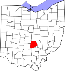 | |
| Villages | ||
| Townships | ||
| CDPs | ||
| Unincorporated communities | ||
| Footnotes | ‡This populated place also has portions in an adjacent county or counties | |
Municipalities and communities of Franklin County, Ohio, United States | ||
|---|---|---|
| Cities |  | |
| Villages | ||
| Townships | ||
| CDPs | ||
| Unincorporated communities | ||
| Footnotes | ‡This populated place also has portions in an adjacent county or counties | |