Phoenix, Oregon
| Phoenix, Oregon | |
|---|---|
| City | |
|
Phoenix City Hall | |
| Motto: The Other Phoenix | |
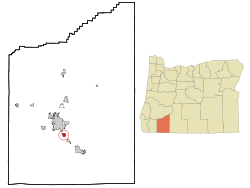 Location in Oregon | |
| Coordinates: 42°16′28″N 122°49′7″W / 42.27444°N 122.81861°WCoordinates: 42°16′28″N 122°49′7″W / 42.27444°N 122.81861°W | |
| Country | United States |
| State | Oregon |
| County | Jackson |
| Incorporated | 1910 |
| Government | |
| • Mayor | Jeff Bellah |
| Area[1] | |
| • Total | 1.44 sq mi (3.73 km2) |
| • Land | 1.44 sq mi (3.73 km2) |
| • Water | 0 sq mi (0 km2) |
| Elevation | 1,543 ft (470.3 m) |
| Population (2010)[2] | |
| • Total | 4,538 |
| • Estimate (2012[3]) | 4,585 |
| • Density | 3,151.4/sq mi (1,216.8/km2) |
| Time zone | Pacific (UTC-8) |
| • Summer (DST) | Pacific (UTC-7) |
| ZIP code | 97535 |
| Area code(s) | 541 and 458 |
| FIPS code | 41-57500[2] |
| GNIS feature ID | 1161474[4] |
| Website | www.phoenixoregon.gov |

Phoenix is a city in Jackson County, Oregon, United States. The population was 4,538 at the 2010 census. Phoenix is a part of the Medford Metropolitan Statistical Area, in the Rogue Valley, and is 3 miles (5 km) southwest of Medford on Interstate 5.
History
The Phoenix area was settled in about 1850 by brothers Hiram and Samuel Colver. Samuel Colver laid out the town in 1854. Early residents included Milton Lindley, who operated a sawmill that provided timbers in 1855 for a blockhouse as well as a flouring mill owned by Sylvester M. Wait. For a time, the settlement was known locally as Gasburg after a talkative employee in the kitchen serving the mill hands. Wait, who was an agent for the Phoenix Insurance Company of Hartford, Connecticut, assigned the official name, Phoenix, to the community and, in 1857, to its post office. Waitsburg, Washington, was later named after Wait.[5]
Geography
According to the United States Census Bureau, the city has a total area of 1.44 square miles (3.73 km2), all of it land.[1]
The city is south of Medford and north of Talent and Ashland along Interstate 5 and Oregon Route 99. This is toward the southern end of the Rogue River Valley, near the Siskiyou Mountains and the border with California.[6]
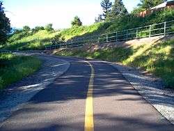
Coleman Creek, a tributary of Bear Creek, joins the larger stream at Phoenix.[6] The Bear Creek Greenway, a biking and hiking trail connecting Ashland, Talent, Medford, and Central Point along Bear Creek, also passes through Phoenix.[7]
Climate
This region experiences hot and dry summers, and cool and wet winters. According to the Köppen Climate Classification system, Phoenix has a hot-summer Mediterranean climate, abbreviated "Csb" on climate maps.[8]
Phoenix's record high temperature is 109 °F (43 °C) on July 20, 1946 and August 8, 1981, and the record low temperature is −8 °F (−22 °C) on December 9, 1972.[9]
| Climate data for Phoenix, Oregon | |||||||||||||
|---|---|---|---|---|---|---|---|---|---|---|---|---|---|
| Month | Jan | Feb | Mar | Apr | May | Jun | Jul | Aug | Sep | Oct | Nov | Dec | Year |
| Record high °F (°C) | 70 (21) |
77 (25) |
81 (27) |
93 (34) |
98 (37) |
107 (42) |
109 (43) |
109 (43) |
106 (41) |
95 (35) |
76 (24) |
68 (20) |
109 (43) |
| Average high °F (°C) | 50 (10) |
56 (13) |
62 (17) |
67 (19) |
76 (24) |
83 (28) |
93 (34) |
92 (33) |
87 (31) |
73 (23) |
56 (13) |
48 (9) |
70 (21) |
| Average low °F (°C) | 31 (−1) |
33 (1) |
35 (2) |
39 (4) |
45 (7) |
50 (10) |
57 (14) |
56 (13) |
49 (9) |
40 (4) |
35 (2) |
31 (−1) |
42 (6) |
| Record low °F (°C) | −1 (−18) |
−1 (−18) |
11 (−12) |
22 (−6) |
25 (−4) |
27 (−3) |
35 (2) |
37 (3) |
26 (−3) |
17 (−8) |
9 (−13) |
−8 (−22) |
−8 (−22) |
| Average precipitation inches (mm) | 2.77 (70.4) |
2.32 (58.9) |
2.26 (57.4) |
1.61 (40.9) |
1.41 (35.8) |
0.77 (19.6) |
0.50 (12.7) |
0.57 (14.5) |
0.95 (24.1) |
1.51 (38.4) |
3.20 (81.3) |
3.27 (83.1) |
21.14 (537.1) |
| Average snowfall inches (cm) | 2.60 (6.6) |
0.50 (1.27) |
0.30 (0.76) |
0.20 (0.51) |
0 (0) |
0 (0) |
0 (0) |
0 (0) |
0 (0) |
0 (0) |
0.10 (0.25) |
1.90 (4.83) |
5.60 (14.22) |
| Source #1: Intellicast (records and precipitation totals):[9] | |||||||||||||
| Source #2: WorldWeatherOnline (average temps):[10] | |||||||||||||
Demographics
| Historical population | |||
|---|---|---|---|
| Census | Pop. | %± | |
| 1880 | 277 | — | |
| 1910 | 250 | — | |
| 1920 | 159 | −36.4% | |
| 1930 | 439 | 176.1% | |
| 1940 | 432 | −1.6% | |
| 1950 | 746 | 72.7% | |
| 1960 | 769 | 3.1% | |
| 1970 | 1,287 | 67.4% | |
| 1980 | 2,309 | 79.4% | |
| 1990 | 3,239 | 40.3% | |
| 2000 | 4,061 | 25.4% | |
| 2010 | 4,538 | 11.7% | |
| Est. 2015 | 4,553 | [11] | 0.3% |
2010 census
As of the census of 2010, there were 4,538 people, 2,001 households, and 1,178 families residing in the city. The population density was 3,151.4 inhabitants per square mile (1,216.8/km2). There were 2,149 housing units at an average density of 1,492.4 per square mile (576.2/km2). The racial makeup of the city was 84.0% White, 0.9% African American, 1.5% Native American, 1.3% Asian, 0.2% Pacific Islander, 7.9% from other races, and 4.3% from two or more races. Hispanic or Latino of any race were 15.8% of the population.[2]
There were 2,001 households of which 24.3% had children under the age of 18 living with them, 42.7% were married couples living together, 10.6% had a female householder with no husband present, 5.5% had a male householder with no wife present, and 41.1% were non-families. 33.1% of all households were made up of individuals and 16.9% had someone living alone who was 65 years of age or older. The average household size was 2.26 and the average family size was 2.87.[2]
The median age in the city was 44 years. 20.7% of residents were under the age of 18; 7.5% were between the ages of 18 and 24; 22.8% were from 25 to 44; 26.9% were from 45 to 64; and 22% were 65 years of age or older. The gender makeup of the city was 46.9% male and 53.1% female.[2]
2000 census
As of the census of 2000, there were 4,060 people, 1,746 households, and 1,117 families residing in the city. The population density was 3,249.8 people per square mile (1,254.1/km²). There were 1,850 housing units at an average density of 1,480.8 per square mile (571.4/km²). The racial makeup of the city was 89.95% White, 0.86% African American, 1.08% Native American, 0.67% Asian, 0.17% Pacific Islander, 4.51% from other races, and 2.76% from two or more races. Hispanic or Latino of any race were 8.89% of the population.[2]
There were 1,746 households out of which 28.5% had children under the age of 18 living with them, 49.6% were married couples living together, 11.1% had a female householder with no husband present, and 36.0% were non-families. 29.3% of all households were made up of individuals and 14.9% had someone living alone who was 65 years of age or older. The average household size was 2.32 and the average family size was 2.84.[2]
In the city the population was spread out with 23.2% under the age of 18, 7.5% from 18 to 24, 24.7% from 25 to 44, 23.5% from 45 to 64, and 21.1% who were 65 years of age or older. The median age was 41 years. For every 100 females there were 90.1 males. For every 100 females age 18 and over, there were 84.0 males.[2]
The median income for a household in the city was $31,701, and the median income for a family was $38,176. Males had a median income of $29,832 versus $23,719 for females. The per capita income for the city was $16,828. About 8.6% of families and 11.6% of the population were below the poverty line, including 19.3% of those under age 18 and 4.3% of those age 65 or over.[2]
Education
Phoenix is part of the Phoenix-Talent School District. The city is the site of two of the five schools in the district—Phoenix Elementary School and Phoenix High School, as well as Armadillo Technical Institute, a public charter school.[13]
Notable people
- Tami Farrell, Miss Oregon Teen USA 2003, Miss Teen USA 2003, Miss California USA 2009
- Shawn Lathrop, actor who appeared on the television series Lost; attended Phoenix High School
- Neighb'rhood Childr'n, 1960s psychedelic rock group
- Bill Pearl, world champion bodybuilder
- Kelin Quinn, lead singer of punk rock band Sleeping With Sirens; attended Phoenix High School
References
- 1 2 "US Gazetteer files 2010". United States Census Bureau. Retrieved 2012-12-21.
- 1 2 3 4 5 6 7 8 9 "American FactFinder". United States Census Bureau. Retrieved 2012-12-21.
- ↑ "Population Estimates". United States Census Bureau. Retrieved 2013-06-02.
- ↑ "US Board on Geographic Names". United States Geological Survey. 2007-10-25. Retrieved 2008-01-31.
- ↑ McArthur, Lewis A.; Lewis L. McArthur (2003) [1928]. Oregon Geographic Names (7th ed.). Portland, Oregon: Oregon Historical Society Press. p. 760. ISBN 0-87595-277-1.
- 1 2 Oregon Road & Recreation Atlas (5th ed.). Santa Barbara, California: Benchmark Maps. 2012. p. 96. ISBN 978-0-929591-62-9.
- ↑ "Map". Bear Creek Greenway Foundation. Retrieved October 12, 2015.
- ↑ "Phoenix, Oregon". Weatherbase. CantyMedia. Retrieved October 5, 2015.]
- 1 2 "Historic Averages for Phoenix, Oregon". Retrieved 2015-05-05.
- ↑ "Phoenix, Oregon: World Weather Online". Retrieved 2015-08-21.
- ↑ "Annual Estimates of the Resident Population for Incorporated Places: April 1, 2010 to July 1, 2015". Retrieved July 2, 2016.
- ↑ "Census of Population and Housing". Census.gov. Retrieved June 4, 2015.
- ↑ Armadillo Technical Institute
External links
Municipalities and communities of Jackson County, Oregon, United States | ||
|---|---|---|
| Cities |  | |
| CDPs | ||
| Other unincorporated communities | ||
| Ghost towns | ||