Phasael tower
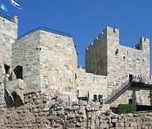
The Herodian tower partially preserved in the Citadel of Jerusalem has been identified as either the Phasael Tower or the Hippicus Tower described by Josephus.[1][2]
The towers named Phasael, Hippicus and Mariamne were situated in the northwest corner of the so-called First Wall, the Hasmonean and Herodian city wall protecting the Western Hill of Jerusalem. They were situated close to where the Jaffa Gate is today and were built by Herod the Great at the same time he built his immediately adjacent royal palace. These towers protected the main entrance to the city, as well as the palace, constituting a potential last refuge for the king. All three towers have vanished except for the base of the Hippicus (or Phasael) Tower, upon which the present "Tower of David" rests.
The towers were named by Herod after his brother Phasael, his friend and general Hippicus who had fallen in battle, and his favourite wife, Mariamne.
When the city was razed in 70 AD, all three towers were left standing, in order to show off the strength of the fortifications the Roman army had to overcome (Josephus, The Wars of the Jews, Book VII, Ch. 1:1 ) With time though, only one of Herod's towers survived - either Phasael, or according to some, including archaeologist Hillel Geva who excavated the Citadel, Hippicus.[1] However, during the Byzantine period, the remaining tower, and by extension the Citadel as a whole, acquired its alternative name - the Tower of David - after the Byzantines, mistakenly identifying the hill as Mount Zion, presumed it to be David's palace mentioned in 2 Samuel 5:11, 11:1-27, 16:22. The Citadel was gradually built up under Muslim and Crusader rule and acquired the basis of its present shape in 1310, under the Mamluk sultan Malik al-Nasir. Suleiman the Magnificent later constructed the monumental gateway in the east that you enter through today. The minaret (no public access), a prominent Jerusalem landmark, was added between 1635 and 1655, and took over the title of "Tower of David" in the nineteenth century, so that the name can now refer to either the whole Citadel or the minaret alone.
On the site itself, from the top of the Hippicus (or Phasael) Tower, there are good views over the excavations inside the Citadel and out to the Old City, as well as into the distance south and west. On the way up, a terrace overlooking the diggings has plaques identifying the different periods of all the remains. These include part of the Hasmonean city wall, a Roman cistern, and the ramparts of the Umayyad citadel, which held out for five weeks before falling to the Crusaders in 1099.
References
- 1 2 Hillel Geva (1981). "The 'Tower of David'—Phasael or Hippicus?". Israel Exploration Journal. Israel Exploration Society. 31 (1/2): 57–65. JSTOR 27925783.
- ↑ Denys Pringle (2009). Jerusalem (No. 115): Citadel, or David's Tower. Secular Buildings in the Crusader Kingdom of Jerusalem: An Archaeological Gazetteer. Cambridge University Press. p. 55. ISBN 9780521102636. Retrieved 27 September 2015.
Coordinates: 31°46′33.9″N 35°13′40.93″E / 31.776083°N 35.2280361°E