Perry Township, Boone County, Indiana
| Perry Township | |
|---|---|
| Township | |
|
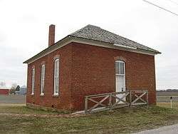
Former Howard School in eastern Perry Township | |
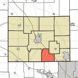 Location of Perry Township in Boone County | |
| Coordinates: 39°56′57″N 86°24′28″W / 39.94917°N 86.40778°WCoordinates: 39°56′57″N 86°24′28″W / 39.94917°N 86.40778°W | |
| Country | United States |
| State | Indiana |
| County | Boone |
| Government | |
| • Type | Indiana township |
| Area | |
| • Total | 20.84 sq mi (54.0 km2) |
| • Land | 20.82 sq mi (53.9 km2) |
| • Water | 0.02 sq mi (0.05 km2) |
| Elevation[1] | 948 ft (289 m) |
| Population (2010) | |
| • Total | 1,163 |
| • Density | 55.8/sq mi (21.5/km2) |
| FIPS code | 18-58968[2] |
| GNIS feature ID | 453716 |
Perry Township is one of twelve townships in Boone County, Indiana. As of the 2010 census, its population was 1,163 and it contained 461 housing units.[3]
History
Howard School was listed on the National Register of Historic Places in 2009.[4]
Geography
According to the 2010 census, the township has a total area of 20.84 square miles (54.0 km2), of which 20.82 square miles (53.9 km2) (or 99.90%) is land and 0.02 square miles (0.052 km2) (or 0.10%) is water.[3]
Unincorporated towns
Adjacent townships
- Center (northwest)
- Eagle (east)
- Harrison (west)
- Worth (northeast)
- Brown Township, Hendricks County (southeast)
- Middle Township, Hendricks County (southwest)
Major highways
Cemeteries
The township contains three cemeteries: Dickerson, Howard and Smith.
References
- ↑ "US Board on Geographic Names". United States Geological Survey. 2007-10-25. Retrieved 2008-01-31.
- ↑ "American FactFinder". United States Census Bureau. Retrieved 2008-01-31.
- 1 2 "Population, Housing Units, Area, and Density: 2010 - County -- County Subdivision and Place -- 2010 Census Summary File 1". United States Census. Retrieved 2013-05-10.
- ↑ National Park Service (2010-07-09). "National Register Information System". National Register of Historic Places. National Park Service.
External links
Municipalities and communities of Boone County, Indiana, United States | ||
|---|---|---|
| City | ||
| Towns | ||
| Townships | ||
| Unincorporated communities |
| |
| Footnotes | ‡This populated place also has portions in an adjacent county or counties | |
This article is issued from Wikipedia - version of the 8/1/2015. The text is available under the Creative Commons Attribution/Share Alike but additional terms may apply for the media files.