Pennsylvania Route 272
| ||||
|---|---|---|---|---|
 | ||||
| Route information | ||||
| Maintained by PennDOT | ||||
| Length: | 54.666 mi[1] (87.976 km) | |||
| Major junctions | ||||
| South end: |
| |||
|
| ||||
| North end: |
| |||
| Location | ||||
| Counties: | Chester, Lancaster, Berks | |||
| Highway system | ||||
| ||||

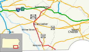
Pennsylvania Route 272 (PA 272) is a 54.7-mile-long (88.0 km) highway in eastern Pennsylvania, in the Lancaster area. The southern terminus of the route is at the Mason–Dixon line southeast of Nottingham, where it continues into Maryland as Maryland Route 272 (MD 272). The northern terminus is at an interchange with U.S. Route 222 (US 222) and PA 568 in Adamstown, where PA 568 continues east. The route heads from the Maryland border northwest through the western corner of Chester County, intersecting US 1 in Nottingham. PA 272 continues west into Lancaster County and intersects US 222 in Wakefield, where it turns north and passes through Buck before widening into a divided highway as it comes to another junction with US 222 in Willow Street. Here, the route becomes unsigned and follow US 222 north through Lancaster along one-way city streets. North of Lancaster, US 222 splits at an interchange with US 30 and PA 272 becomes signed again, heading northeast parallel to the freeway alignment of US 222 and passing through Akron, Ephrata (where it intersects US 322), and Adamstown. The route enters Berks County and comes to its northern terminus.
PA 272 was first designated in 1928 to run from US 222/PA 72 in Wakefield east to US 1/PA 12 in Nottingham. The route was fully paved by 1940. In the 1940s, PA 272 was extended south from Nottingham to the Maryland border, replacing a section of PA 42 between the Maryland border and Chrome. The route was extended north from Wakefield to US 222 in Willow Street in the 1960s. This extension replaced what became a southern extension of PA 72 from Lancaster in the 1930s. The route was extended from Willow Street to US 222 and PA 568 in Adamstown following the completion of the US 222 freeway between Lancaster and Adamstown in 1977. PA 272 followed US 222 through Lancaster and ran along the former alignment of US 222 between Lancaster and Adamstown. In 2006, the intersection at the northern terminus was converted to an interchange following the extension of the US 222 freeway from Adamstown to the Reading area.
Route description
PA 272 is mostly in Lancaster County, except for about a mile at the northern terminus where it enters Berks County and the southernmost part of the route, which is in Chester County. In downtown Lancaster, it is unsigned but concurrent with US 222.[2][3][4][5]
Maryland state line to Lancaster
The southern terminus of PA 272 is at the Maryland state line in East Nottingham Township in Chester County, where it continues south into that state as MD 272. From the state line, the route heads north on two-lane undivided Chrome Road through a mix of farmland and woodland. In the community of Chrome, PA 272 turns west on Christine Road and continues northwest through agricultural areas with some trees and homes. The road crosses North East Creek into West Nottingham Township and runs through more rural areas before reaching the community of Nottingham. Here, the route passes homes and comes to a bridge over an East Penn Railroad line before it intersects Baltimore Pike to the north of the Herr's Snacks plant. PA 272 passes a mix of residences and businesses and comes to an interchange with the US 1 freeway. Past this interchange, the road heads through a mix of farmland and residential subdivisions, reaching the community of Glen Roy. The route continues west into wooded areas with some fields.[2][3]
PA 272 crosses the Octoraro Creek into Little Britain Township in Lancaster County and becomes Nottingham Road, curving northwest into agricultural areas with some trees and homes. The road reaches the community of Oak Hill and turns west, passing through more rural land. The route passes near residential development in the community of Little Britain before it continues through farmland and passes through Oakryn. PA 272 enters Fulton Township and runs through agricultural areas with occasional homes, reaching an intersection with US 222 in the community of Wakefield. At this point, the route turns north for a concurrency with US 222 along Robert Fulton Highway, running through a mix of farms and homes. PA 272 splits from US 222 in the community of Penn Hill by heading northwest along Lancaster Pike. The road heads through agricultural areas with some trees and homes, curving north and leaving Fulton Township, where it becomes the border between Drumore Township to the west and East Drumore Township to the east. The route continues through rural areas and turns northwest, passing through the communities of Hensell and Drumore Center. PA 272 curves north and runs through more farmland with some residential and commercial development before coming to an intersection with PA 372 in the community of Buck. At this intersection, PA 272 crosses westbound PA 372 while eastbound PA 372 turns north for a short concurrency with northbound PA 272 before it splits to the east.[2][4]
Past Buck, PA 272 crosses into Providence Township and runs through a mix of farmland and woodland with some commercial development, passing to the east of Buck Motorsports Park and bending northwest. The road continues north through farms and woods with some homes and businesses. The route widens into a four-lane divided highway and the travel lanes split as the road heads northwest through wooded areas and passes under the abandoned Atglen and Susquehanna Branch. Both directions of PA 272 rejoin in the community of Smithville and it continues north as a four-lane divided highway through a mix of farms and woods with some homes and businesses, curving northwest. The road crosses Pequea Creek into Pequea Township and becomes Willow Street Pike, continuing through rural areas with some development before reaching Willow Street. Between Smithville and Willow Street, a few of the intersections along the divided highway are controlled by jughandles. In Willow Street, both directions of the route split, with the northbound direction heading into residential and commercial areas, while the southbound direction bypasses Willow Street to the west through farmland. PA 272 continues into West Lampeter Township and runs through more developed areas in Willow Street before it comes to a junction with US 222/PA 741.[2][4]
At this point, US 222 turns north to join PA 272 along Willow Street Pike, and PA 272 becomes unsigned along the US 222 concurrency. Both directions of Willow Street Pike rejoin and it continues north as a two-lane undivided road past commercial development before it runs through wooded residential areas, passing through Hollinger. US 222/PA 272 crosses Mill Creek and heads through the community of Lyndon. The road briefly gains a center left-turn lane as it continues through wooded areas of development and passes to the west of a golf course. US 222/PA 272 splits into a one-way pair, with two lanes in each direction, and crosses the Conestoga River into Lancaster Township.[2][4]
Lancaster to Adamstown
After crossing the Conestoga River, northbound US 222/PA 272 becomes Highland Avenue and southbound US 222/PA 272 is called South Prince Street. The southbound direction intersects PA 324 in the community of Engleside before the two routes continue into the city of Lancaster, heading into urban residential and commercial areas. A short distance after entering Lancaster, northbound US 222/PA 272 intersects the end of one-way northbound PA 324 and heads onto South Queen Street. The two routes continues past urban rowhomes along South Queen Street northbound and South Prince Street southbound. Northbound US 222/PA 272 splits from South Queen Street by heading northeast onto Church Street, which carries three lanes of one-way traffic, while northbound PA 72 continues along South Queen Street. Just south of downtown Lancaster, the northbound direction of the route turns north onto South Lime Street, which carries two lanes of one-way traffic. US 222/PA 272 heads into the commercial downtown of Lancaster and crosses eastbound PA 462 at King Street. Past this, the route becomes North Lime Street northbound and North Prince Street southbound, crossing eastbound PA 23 at Chestnut Street and westbound PA 23/PA 462 at Walnut Street. The two routes leave the downtown area and run through urban areas of homes and businesses. The northbound direction passes to the east of Lancaster General Hospital between East James and East Frederick streets while the southbound direction passes to the east of Clipper Magazine Stadium, home of the Lancaster Barnstormers baseball team, north of the Harrisburg Avenue intersection. At the intersection with Liberty Street, northbound US 222/PA 272 shifts west a block while the one-way pair continues into Manheim Township. A block later, at McGovern Avenue, both directions of US 222/PA 272 rejoin along Lititz Pike. Southbound US 222/PA 272 follows McGovern Avenue west between Lititz Pike and North Prince Street, forming the border between a portion of the city of Lancaster to the north that is home to the Lancaster Station along Amtrak's Philadelphia to Harrisburg Main Line and Manheim Township to the south. The roadway carries two-lanes of one-way traffic to an intersection with northbound PA 72 at North Queen Street. Here, northbound PA 72 turns west to join southbound US 222/PA 272 along McGovern Avenue, which carries three lanes westbound. At North Prince Street, southbound US 222/PA 272 turn south while PA 72 becomes two-way heading north.[2][4]
Both directions of US 222/PA 272 continue north along four-lane undivided Lititz Pike and the road reaches a bridge over Amtrak's Philadelphia to Harrisburg Main Line, where it becomes the border between Manheim Township to the west and Lancaster to the east. At Keller Avenue, the road fully enters Manheim Township and runs through commercial areas as a five-lane road with a center left-turn lane. Northbound US 222 and PA 272 head northeast onto Oregon Pike, with PA 272 becoming signed again, while southbound US 222 and PA 501 continue north along Lititz Pike. The two routes continue northeast as a three-lane road with a center left-turn lane and runs past businesses and a few homes before it comes to an interchange with the US 30 freeway. Here, US 222 heads east along US 30 and PA 272 continues northeast along Oregon Pike, passing through commercial areas and narrowing to two lanes. The road continues through suburban areas of homes and businesses and passes through the community of Roseville. Farther northeast, the route widens to a divided highway at the Landis Valley Road intersection, where it passes to the southeast of the Landis Valley Museum in the community of Landis Valley. PA 272 becomes undivided again and passes through wooded residential areas before it enters farmland. The route becomes parallel to the US 222 freeway located to the southeast and reaches direct ramps to and from the southbound lanes of US 222. Access to and from the northbound lanes is provided by Jake Landis Road, which passes under US 222 and connects to Butter Road, which provides access to the ramps. The route heads through wooded areas and passes over Lititz Run before it comes to the eastern terminus of PA 722 near the community of Oregon.[2][4]
The road heads into agricultural areas and enters Warwick Township prior to crossing Cocalico Creek into West Earl Township. The route heads through residential areas with some commercial development before it enters business areas, where it gains a center left-turn lane briefly before it becomes a divided highway and crosses PA 772 near Brownstown. Past this, PA 272 narrows back into a two-lane undivided road and runs through a mix of farm fields and commercial development, curving to the north. The road becomes the border between West Earl Township to the west and the borough of Akron to the east, running past homes and businesses. The route fully enters Akron and becomes South 7th Street, passing more development. PA 272 becomes North 7th Street upon crossing Main Street and continues through residential and commercial areas. The road passes through woods and leaves Akron, where it becomes the border between Ephrata Township to the west and the borough of Ephrata to the east, where the name changes to South Reading Road. The route heads north-northeast through business areas and fully enters Ephrata, turning north. PA 272 crosses Cocalico Creek and curves northeast through a mix of homes and businesses. The road widens to a four-lane divided highway and reaches a cloverleaf interchange with US 322. Past this, the route becomes North Reading Road and runs through business areas as a three-lane road with a center left-turn lane, passing to the north of Ephrata Community Hospital. PA 272 continues through commercial areas as it forms the border between Ephrata Township to the northwest and the borough of Ephrata to the southeast.[2][4]
The route fully enters Ephrata Township and narrows to a two-lane road as it runs through a mix of farmland and commercial development, passing over an East Penn Railroad line. The road crosses into East Cocalico Township and continues through agricultural areas with some homes and businesses, again crossing Cocalico Creek. PA 272 passes through the residential community of Reamstown, where it turns to the east. The route curves northeast past commercial development and comes to an intersection with Colonel Howard Boulevard, which heads east to provide access to the US 222 freeway and the Pennsylvania Turnpike (I-76) at the Reading interchange. A short distance later, the road comes to a bridge over the Pennsylvania Turnpike. PA 272 gains a center left-turn lane and continues past businesses, eventually narrowing back to two lanes. The road passes more commercial development with some homes and crosses PA 897 in the community of Swartzville. Past this intersection, the route continues through developed areas and enters the borough of Adamstown. PA 272 heads through wooded areas with some homes and businesses as it passes through the borough. After leaving Adamstown, the road passes through a small corner of Brecknock Township.[2][4] PA 272 enters Brecknock Township in Berks County and passes commercial development before it comes to its northern terminus at an interchange with the US 222 freeway. Past this interchange, the road continues east as PA 568.[2][5]
History
The Willow Street Turnpike Road Company was chartered on April 5, 1849 to build a private turnpike between Willow Street and Lancaster. On March 25, 1850, the Lancaster and Ephrata Turnpike and Plank Road Company was charted to build a turnpike between Lancaster and Ephrata.[6] This turnpike became known as the Oregon Turnpike.[7] When Pennsylvania first legislated routes in 1911, the road between Willow Street and Lancaster was designated as part of Legislative Route 136 while the road between Brownstown and Adamstown served as part of Legislative Route 148, which connected Lancaster to Reading.[8] With the establishment of the U.S. Highway System in 1926, the road between Willow Street and Lancaster became a part of US 230 while the road between Brownstown and Adamstown was a part of US 222.[9] In 1927, PA 72 was designated concurrent with US 230 between Willow Street and Lancaster while PA 41 ran concurrent with US 222 between Brownstown and Adamstown.[10]
PA 272 was designated in 1928 to run from US 222/PA 72 in Wakefield east to US 1/PA 12 (Baltimore Pike) in Nottingham, with the road unpaved in Lancaster County and paved in Chester County. Also, the road between the Maryland border and Chrome became the southernmost portion of PA 42. At this time, US 222 replaced the US 230 designation south of Lancaster and PA 240 replaced the PA 41 designation along US 222 between Brownstown and Adamstown.[11] By 1930, PA 272 was paved between PA 172 in Little Britain and the Octoraro Creek. In addition, PA 722 was designated onto the Oregon Pike between Oregon and Brownstown while the concurrent state route designations were removed from US 222.[12] In the 1930s, PA 272 was paved between Wakefield and Little Britain. Also, a southern extension of PA 72 was designated onto the straight road between Wakefield and Willow Street. US 222 was also realigned to use Oregon Pike between Lancaster and Brownstown, replacing the easternmost portion of PA 722.[13] US 222 was also moved to a new alignment between Ephrata and Reamstown in 1944, having previously followed State Street and Reamstown Road. This new alignment included an interchange with US 322.[14][15] PA 272 was extended south from Nottingham to the Maryland border in the 1940s, replacing the southernmost section of PA 42.[14]
In the 1960s, PA 272 was extended north from Wakefield to US 222 in Willow Street, replacing the section of PA 72 between Wakefield and Willow Street. Also, the route was widened to a divided highway between Smithville and Willow Street.[16] In July 1977, the US 222 freeway was completed between Lancaster and the Berks County border near Adamstown.[17] As a result, PA 272 was extended north from Willow Street to run concurrent with US 222 through Lancaster before following the former surface alignment of US 222 between Lancaster and Adamstown, ending at an intersection with US 222 and PA 568.[18] In 2006, the intersection with US 222 and PA 568 at the northern terminus was replaced with an interchange as part of upgrading US 222 to a freeway between Adamstown and Reading.[17]
Major intersections
| County | Location | mi[1] | km | Destinations | Notes |
|---|---|---|---|---|---|
| Chester | East Nottingham Township | 0.000 | 0.000 | Continuation into Maryland | |
| West Nottingham Township | 3.335 | 5.367 | Interchange | ||
| Lancaster | Fulton Township | 12.584 | 20.252 | Southern terminus of concurrency | |
| 13.055 | 21.010 | Northern terminus of concurrency | |||
| Drumore–East Drumore township line | 19.982 | 32.158 | Southern terminus of PA 372 eastbound concurrency | ||
| 20.221 | 32.543 | Northern terminus of PA 372 eastbound concurrency | |||
| West Lampeter Township | 28.667 | 46.135 | Southern terminus of US 222/PA 272 concurrency | ||
| Lancaster Township | 31.478 | 50.659 | No direct access from northbound US 222 / PA 272 to PA 324, northern terminus of PA 324 | ||
| Lancaster | 32.195 | 51.813 | No access from southbound US 222 / PA 272, southern terminus of PA 72 northbound | ||
| 32.614 | 52.487 | ||||
| 32.832 | 52.838 | ||||
| 32.941 | 53.013 | ||||
| 33.697 | 54.230 | No direct access between northbound US 222 / PA 272 and PA 72, southern terminus of PA 72 southbound | |||
| Manheim Township | 34.326 | 55.242 | Southern terminus of PA 501 | ||
| 34.767 | 55.952 | Interchange, northern terminus of US 222/PA 272 concurrency | |||
| 38.145– 38.426 | 61.388– 61.841 | Interchange, access to and from northbound lanes of US 222 provided by Jake Landis Road and Butter Road | |||
| 39.349 | 63.326 | Eastern terminus of PA 722 | |||
| West Earl Township | 41.154 | 66.231 | |||
| Ephrata | 45.385 | 73.040 | Interchange | ||
| East Cocalico Township | 50.929 | 81.962 | Connector to the Pennsylvania Turnpike and US 222 | ||
| 52.173 | 83.964 | ||||
| Berks | Brecknock Township | 54.666 | 87.976 | Interchange, western terminus of PA 568 | |
1.000 mi = 1.609 km; 1.000 km = 0.621 mi
| |||||
See also
 U.S. Roads portal
 Pennsylvania portal
 Lancaster, Pennsylvania portal
References
- 1 2 Bureau of Maintenance and Operations (January 2015). Roadway Management System Straight Line Diagrams (Report) (2015 ed.). Pennsylvania Department of Transportation. Retrieved June 30, 2015.
- Chester County (PDF)
- Lancaster County (PDF)
- Berks County (PDF)
- 1 2 3 4 5 6 7 8 9 10 Google (June 23, 2013). "Pennsylvania Route 272" (Map). Google Maps. Google. Retrieved June 23, 2013.
- 1 2 Chester County, Pennsylvania Highway Map (PDF) (Map). PennDOT. 2014. Retrieved December 19, 2014.
- 1 2 3 4 5 6 7 8 Lancaster County, Pennsylvania Highway Map (PDF) (Map). PennDOT. 2014. Retrieved December 19, 2014.
- 1 2 Berks County, Pennsylvania Highway Map (PDF) (Map). PennDOT. 2014. Retrieved December 22, 2014.
- ↑ Beitel, Calvin Gustavus (1874). A Digest of Titles of Corporations Chartered by the Legislature of Pennsylvania. pp. 411, 451. Retrieved February 19, 2015.
- ↑ "Seeing Lancaster County from a Trolley Window". The Pennsylvania-German. 10. Lititz, PA: The Express Printing Co. 1909. p. 612. Retrieved February 19, 2015.
- ↑ Map of Pennsylvania Showing State Highways (PDF) (Map). Pennsylvania Department of Highways. 1911. Retrieved January 1, 2014.
- ↑ Pennsylvania Highway Map (eastern side) (Map). Gulf Oil. 1926. Retrieved December 26, 2007.
- ↑ Pennsylvania Highway Map (Map). Pennsylvania Department of Highways. 1927. Retrieved December 26, 2007.
- ↑ Pennsylvania Highway Map (Philadelphia Metro) (Map). Gulf Oil. 1928. Retrieved November 8, 2007.
- ↑ Tourist Map of Pennsylvania (PDF) (Map). Pennsylvania Department of Highways. 1930. Retrieved January 1, 2014.
- ↑ Official Road Map of Pennsylvania (PDF) (Map). Pennsylvania Department of Highways. 1940. Retrieved December 16, 2014.
- 1 2 Official Road Map of Pennsylvania (PDF) (Map). Pennsylvania Department of Highways. 1950. Retrieved January 1, 2014.
- ↑ Federal Highway Administration (2012). "NBI Structure Number: 000000000021155". National Bridge Inventory. Federal Highway Administration.
- ↑ Official Map of Pennsylvania (PDF) (Map). Pennsylvania Department of Highways. 1970. Retrieved December 17, 2014.
- 1 2 Youker, Darrin (June 18, 2006). "The wait is over". Reading Eagle. p. A9. Retrieved January 11, 2012.
- ↑ Pennsylvania Official Transportation Map (PDF) (Map). Pennsylvania Department of Transportation. 1980. Retrieved January 29, 2015.
External links
| Wikimedia Commons has media related to Pennsylvania Route 272. |