Pemba Island
| Native name: <span class="nickname" ">Al Jazeera al Khadra (the green island) | |
|---|---|
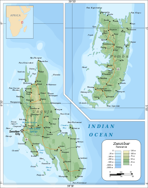 The main islands of the Zanzibar Archipelago: Unguja (left) and Pemba (right) | |
| Geography | |
| Location | Indian Ocean |
| Coordinates | 5°10′S 39°47′E / 5.167°S 39.783°ECoordinates: 5°10′S 39°47′E / 5.167°S 39.783°E |
| Area | 988 km2 (381 sq mi) |
| Administration | |
|
Tanzania | |
| Region | Zanzibar |
| Largest settlement | Wete |
| Demographics | |
| Population | 406,808 (census 2012) |
| Pop. density | 428 /km2 (1,109 /sq mi) |
Pemba Island, known as "The Green Island" in Arabic (الجزيرة الخضراء), is an island forming part of the Zanzibar Archipelago, lying within the Swahili Coast in the Indian Ocean.
Geography
With a land area of 988 square kilometres (381 sq mi)[1] it is situated about 50 kilometres (31 mi) to the north of Unguja, the largest island of the archipelago. In 1964, Zanzibar was united with the former colony of Tanganyika to form Tanzania. It lies 50 kilometres (31 mi) east of mainland Tanzania, across the Pemba Channel. Together with Mafia Island (south of Unguja), these islands form the Spice Islands (not to be confused with the Maluku Islands of Indonesia).

Most of the island, which is hillier and more fertile than Unguja, is dominated by small scale farming. There is also large scale farming of cash crops such as cloves.
In previous years, the island was seldom visited due to inaccessibility and a reputation for political violence, with the notable exception of those drawn by its reputation as a center for traditional medicine and witchcraft. There is a quite large Arab community on the island, who immigrated from Oman. The population is a mix of Arab and original Waswahili inhabitants of the island. A significant portion of the population also identifies as Shirazi people.
The most important towns in Pemba are Chake-Chake (the capital), Mkoani, and Wete, which is the largest city. The centrally located Chake-Chake is perched on a mound with a view to the west on a bay and the tiny Misali Island, where the tides determine when a dhow can enter the local harbour. Pemba is, with the exception of a strip of land along its eastern coast, a very fertile place: besides clove trees, the locals grow mainly rice, coconut, bananas, cassava and red beans (called maharagwe in the Swahili language).
Pemba is home to several dive sites, with steep drop-offs, untouched coral and very abundant marine life.[2][3]
Archaeology

Archaeological research on Pemba has shown its centrality to the Swahili coast trading system as early as 600 AD.[4] Along the northern coast, urban settlements at Chwaka later developed and flourished from the eleventh century to ~1500 AD.[5]
West of Pemba's capital Chake-Chake, on a long stretched peninsula called Ras Mkumbuu, one can find some of the oldest and best preserved series of early ruins on the islands (Ndagoni ruins, probably 14th century).[6]
East of Chake-Chake one can find the Mkama Ndume ruins at Pujini village (south of the airport) within easy reach by road from Chake-Chake. This is the only known early fortification on the whole Swahili Coast; it is dated to the fifteenth century.[7]
History
According to the Arab geographer Yakut, in the mid-13th century there were two independent sultans ruling over parts of Pemba Island.[8]
On 24 June 2016, the Australian Transport Minister, Darren Chester, said that a piece of aircraft debris was found on Pemba Island, possibly being from the missing Malaysia Airlines Flight 370.[9]
Economy
Pemba is also famous for its rich fishing grounds. Between the island and the mainland there is the deep 50 kilometre wide Pemba Channel, which is one of the most profitable fishing grounds for game fishing on the Swahili Coast.[10]
A large proportion of the Zanzibar export earnings comes from cloves. The greatest concentration of clove trees is found on Pemba (3.5 million trees) as growing conditions here are superior to those on Unguja island. Clove trees grow to the height of around 10 to 15 metres and can produce crops for over 50 years.
More recently with the booming tourism industry in neighbouring Zanzibar, more adventurous travellers are seeking out the less-crowded Pemba, led by dive tourists seeking the uncrowded and un-spoiled reefs the island offers the experienced diver.[11]
For the promotion of tourism the department of Surveys and Mapping at Chake-Chake has published a map with tourist guide since 1992.[12]
Transport
Pemba Airport is also known as Wawi Airport or Karume Airport and connects the island to Arusha, Dar es Salaam and Zanzibar.
Image gallery
 View from Chake Chake town center over the mangroves towards the sea
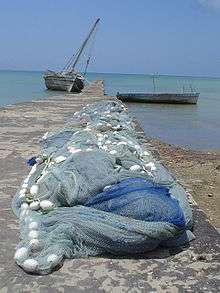 Wharf at Mkoani
 The Pemba offices of the Prime Minister of Zanzibar's Revolutionary Government in Chake Chake
 Derelict amusement park on the outskirts of Chake-Chake
 Clove buds dried in the equatorial sun
 A family from Pemba
 Aircraft at Karume airport Chake-Chake
 A rainy day in central Chake Chake
.jpg) Map of Pemba Island
Map of Pemba Island Fish market, Mkoani
 Market building in Wete
 The jetty at Chake Chake, surrounded by mangroves
 An office of the opposition party CUF (Civic United Front) in Chake Chake
See also
References
- ↑ Tanzania in figures 2012, National Bureau of Statistics, Ministry of Finance, June 2013, page 7
- ↑ "Africa: Dive of a lifetime on Pemba Island". 2 March 2010. Retrieved 11 March 2012.
- ↑ "Divernet: Fun at Fundu". Retrieved 11 March 2012.
- ↑ Fleisher, Jeffrey; LaViolette, Adria (2013). "The early Swahili trade village of Tumbe, Pemba Island, Tanzania, AD 600–950". Antiquity. 87 (338): 1151–1168.
- ↑ LaViolette, Adria; Fleisher, Jeffrey (2009). "The Urban History of a Rural Place: Swahili Archaeology on Pemba Island, Tanzania, 700–1500 AD". International Journal of African Historical Studies. 42 (3): 433–455.
- ↑ Kirkman, James S. "Excavations at Ras Mkumbuu on the island of Pemba." Tanganyika Notes and Records 53 (1959): 161-78.
- ↑ LaViolette, Adria (2004). Swahili archaeology and history on Pemba, Tanzania: A critique and case study of the use of written and oral sources in archaeology. In Reid, Andrew M. and Paul J. Lane, eds. African Historical Archaeologies, pp. 125-162.
- ↑ Marina Tolmacheva, The Pate Chronicle (East Lansing: Michigan State University Press, 1993) p. 6
- ↑ "Potential MH370 debris found on island off African coast". The Washington Post. Associated Press. 24 June 2016. Retrieved 24 June 2016.
- ↑ "The Pemba Channel Fishing Club". Retrieved 8 October 2011.
- ↑ "Spice and easy: Rory Bremner visits Zanzibar and Pemba". 12 February 2012. Retrieved 11 March 2012.
- ↑ Pemba - The clove island 1:100,000, Map & Guide, 3rd edition, 2013, Dept. of Surveys and Mapping, Box 235, Chake-Chake
External links
| Wikimedia Commons has media related to Pemba Island. |
- Short documentary about Pemba Island on YouTube
- Audio interview with Pemba Island resident about life on Pemba Island
