Peć Bistrica
| Peć Bistrica (Пећка Бистрица) Lumbardhi i Pejës | |
|---|---|
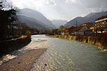 The Peć Bistrica in Peć | |
| Country | Kosovo |
| Basin | |
| Main source |
Mokra mountain, near the Kosovo-Montenegrin border 1,900 m (6,200 ft) |
| River mouth | White Drin, south of Klina, Kosovo[lower-alpha 1] |
| Basin size | 505 km2 (195 sq mi) |
| Physical characteristics | |
| Length | 62 km (39 mi) |
The Peć Bistrica (Serbian: Пећка Бистрица, Pećka Bistrica; Albanian: Lumbardhi i Pejës) is a river in Kosovo[lower-alpha 1]. This 62 km-long right tributary to the White Drin river flows entirely within the south-western part of Kosovo.
Name
The name Bistrica means "clearwater" in Serbian. The adjective Pećka, "of Peć", is added to distinguish it from other Bistrica rivers in the Metohija region: Dečanska Bistrica ("of Dečani"), Prizrenska Bistrica ("of Prizren"), Kožnjarska Bistrica ("of Kožnjar"), Loćanska Bistrica ("of Loćan"), etc.
Upper Course
The Peć Bistrica originates from the eastern slopes of the Mokra mountain, on the border of Kosovo and Montenegro, at the altitude of 1,900 m, in the Rugovo region of Metohija. It flows to the south and initially receives many small streams coming down from the neighboring mountains of Hajla, Micinat and Bogićevica. Passing next to the villages of Boge, Hadžovići and Kućište, on the northern tip of the Micinat mountain it turns east into the Rugovo gorge.
Rugovska Gorge
The short but powerful Peć Bistrica carved the impressive Rugova Canyon, between the mountains of Žljeb mountain on the north, and Koprivnik, the northern extension of the Prokletije mountains, on the south.
The gorge is 23 km long and up to 1,000 m deep. The power of the water cut its way not only through the limestone and slate, but also through the terrain made of marble and serpentine. The upper part of the gorge is the glacial trough of the ancient, 25 km-long, Rugovo glacier.
The gorge is sparsely inhabited (the village of Mali Štupelj).
Lower Course
As it comes out of the gorge, the Peć Bistrica reaches the town of Peć and enters the bottom of the Metohija depression through which it flows for the rest of its course. It runs parallel to the flows of the White Drin to the north and the Dečanska Bistrica to the south, next to the villages of Goraždevac, Lješane, Jablanica, Drenovce and Zaimovo, before it empties into the White Drin south of the town of Klina.
Characteristics
The Peć Bistrica has a large potential for production of hydroelectricity, but this resource is not used. Also, the river is known for its abundance in fish, most notably, the trout.
The river valley, including the Rugovo Canyon, is a route for the road connecting Kosovo with Montenegro, over the Čakor pass.
Through the White Drin, the Peć Bistrica belongs to the Adriatic Sea drainage basin. The river drains an area of 505 m² itself and it is not navigable.
References
| Wikimedia Commons has media related to Peć Bistrica. |
- Mala Prosvetina Enciklopedija, Third edition (1985); Prosveta; ISBN 86-07-00001-2
- Jovan Đ. Marković (1990): Enciklopedijski geografski leksikon Jugoslavije; Svjetlost-Sarajevo; ISBN 86-01-02651-6
Notes
- 1 2 Kosovo is the subject of a territorial dispute between the Republic of Kosovo and the Republic of Serbia. The Republic of Kosovo unilaterally declared independence on 17 February 2008, but Serbia continues to claim it as part of its own sovereign territory. The two governments began to normalise relations in 2013, as part of the Brussels Agreement. Kosovo has received recognition as an independent state from 110 out of 193 United Nations member states.
Coordinates: 42°34′53″N 20°34′06″E / 42.5815°N 20.5684°E