Pawan River
| Pawan River | |
|---|---|
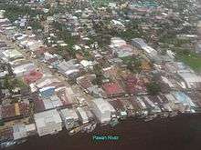 The Pawan at Ketapang | |
 Pawan River drainage basin | |
| Country | Indonesia |
| Basin | |
| Main source | West Kalimantan, Borneo |
| Physical characteristics | |
| Length | 197 kilometres (122 mi) |
Pawan River is a major river of West Kalimantan, Indonesia.[1] It has a length of 197 kilometres (122 mi).[2] Tributaries include the Keriau River.
Geography
In its mid course Pawan River passes through the little town of Tandjoengpoera (Tanjungpura). Pawan River passes through Ketapang before passing into the South China Sea at 1°49′30″S 109°55′9″E / 1.82500°S 109.91917°E. It is 45 miles (72 km) to the south of Sukadana town. Sukadana means the "city of rays" and known as diamond city. The Pawan river drains into the sea near the present Ketapang through two estuaries; which are meandering channels. The depth of water here is about 6 feet (1.8 m) during spring tide. Tanjungpura is situated about 35 miles (56 km) in the upstream. The river forms one of the major river basins in West Kalimantan Province in the Ketapang Regency (478 kilometres (297 mi) from Pontianak) whose capital is Ketapang. Tropical peats have been identified in its basin area.[3][4]
The river is navigable and bandungs ply on the river. Bandung is not only a transportation means for the people but also a housing unit a sincere they travel long the river course trading along the route in villages on the banks of the river.[5]
History
Historically the Pawan River passed through the Kingdom of Ulu. It has been inferred that the Pawan River basin was under the influence of powerful tribal group of the “Indianised Javanese kingdom of Majapahit”, in the 15th century or earlier. Some traders of this group settled here in the valley in the coastal town of Sukadana and subsequently moved up along the river valley for trading in timber and other goods. Marriage alliances between the trading community and the tribal chiefs daughters legitimised the trading practices. From the 16th century onwards, the surrounding area, upstream of the river valley, was under the control of Dayak Kings (Indianized kings); this was a vast area of the "Dayak kingdom" not only in the upper Pawan River valley but it also extended to the upper Sekadau, across the basin boundary. This area was considered safe from attacks from the pirates and as a result, gold and diamond trade is stated to have flourished till the sultanate of Pontianak created serious economic hurdles to the kingdom of Sanggau.[6][7]
Forest area
The Ketapang Forest area is managed under the Forest Management District office (KPH) which has nine sub districts south of the Pawan River and five sub districts to the north of the river, in the Batu ampar KPH in the Pontinak district.[8]
Fauna
The Bornean orangutan, also found in the forest along the Pawan river in West Kalimantan, are facing severe habitat loss due to logging and clearing land for palm oil and related agriculture activities. Consequently, their population is declining. The orangutans in this region are from the sub-species Pongo pygmaeus wurmbii. They are different from the species found in Sumatra.[9]
See also
References
- ↑ Rand McNally, The New International Atlas, 1993.
- ↑ "West Kalimantan" (PDF). Embassy of Indonesia Doha. Retrieved October 30, 2010.
- ↑ "Horizontal and Vertical Distribution of Carbon, Nitrogen and Sulfur Concentrations in Sungai Putri Peat Forest, Ketapang District of West Kalimantan Province, Indonesia" (pdf). Tanjungpura University, Pontianak, Indonesia. Retrieved 2010-11-01.
- ↑ "Places of Interest in West Kalimantan". Archipela Go West Kalimantan. Retrieved 2010-11-01.
- ↑ "Kalimantan as a Tourism Destination". West Kalimantan. Kalimanatan, the Passion for Adventure Travelers. Retrieved 2010-11-01.
- ↑ "The kingdom of Ulu are in Borneo's history: a comment. (Research Notes)". The Free Library. Retrieved 2010-11-01.
- ↑ "The kingdom of Ulu are in Borneo's history: a comment.". Borneo Research Council. 1999. Retrieved October 30, 2010.
- ↑ Soetarto, Endriatmo; Soetarto, M. T. Felix Sitorus; M. Yusup Napiri (2001). Decentralisation of administration, policy making and forest management in ... Center for International Forestry Research (CIFOR). ISBN 979-8764-85-4.
- ↑ "Little resilience in the face of logging and fire". WWF. Retrieved 2010-11-01.
External links
Coordinates: 1°43′45″S 110°12′37″E / 1.72917°S 110.21028°E