Pavullo nel Frignano
| Pavullo nel Frignano | ||
|---|---|---|
| Comune | ||
| Comune di Pavullo nel Frignano | ||
|
Montecuccoli's Castle | ||
| ||
 Pavullo nel Frignano Location of Pavullo nel Frignano in Italy | ||
| Coordinates: 44°20′N 10°50′E / 44.333°N 10.833°ECoordinates: 44°20′N 10°50′E / 44.333°N 10.833°E | ||
| Country | Italy | |
| Region | Emilia-Romagna | |
| Province / Metropolitan city | Modena (MO) | |
| Frazioni | Benedello, Camatta, Castagneto, Coscogno, Crocette, Frassineti, Gaiato, Iddiano, Miceno, Montebonello, Montecuccolo, Monteobizzo, Montorso, Monzone, Niviano, Olina, Querciagrossa, Renno, Sant'Antonio, Sassoguidano, Verica | |
| Government | ||
| • Mayor | Luciano Biolchini | |
| Area | ||
| • Total | 144.07 km2 (55.63 sq mi) | |
| Elevation | 682 m (2,238 ft) | |
| Population (31 July 2015)[1] | ||
| • Total | 17,382 | |
| • Density | 120/km2 (310/sq mi) | |
| Demonym(s) | Pavullesi | |
| Time zone | CET (UTC+1) | |
| • Summer (DST) | CEST (UTC+2) | |
| Postal code | 41026 | |
| Dialing code | 0536 | |
| Patron saint | St. Bartholomew | |
| Website | Official website | |
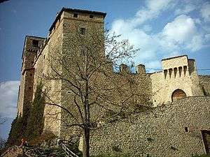

Pavullo nel Frignano is a town and comune in the province of Modena, Emilia-Romagna, Italy, in the Modenese Apeninnes. It is home to the medieval Castle of Montecuccolo, birthplace of the 17th century condottiero Raimondo Montecuccoli, and of the pieve of San Giovanni Battista di Renno (8th-9th century AD).
Economy is mostly based on agriculture. The 2006 World Cup winning Italian footballer Luca Toni was born in Pavullo nel Frignano.
The airport Pavullo nel Frignano Airport is in the commune.
Sources
This article is issued from Wikipedia - version of the 8/16/2016. The text is available under the Creative Commons Attribution/Share Alike but additional terms may apply for the media files.