Passu
Coordinates: 36°28′N 74°54′E / 36.467°N 74.900°E

Passu is a small village on the Karakoram Highway, beside the Hunza River, some 15 kilometers from Gulmit, the Tehsil headquarters of Gojal in the Gilgit-Baltistan region of Pakistan, and about 150 km upriver from Gilgit. It lies very near the tongue of the Passu Glacier, and just south of the tongue of the Batura Glacier. The latter is the seventh longest non-polar glacier in the world at 56 km, and reaches very near to the highway. The people are Wakhi and speak the Wakhi Language. Religiously they are Ismaili, a sect of Shia Islam.
Tupopdan, 6,106 metres (20,033 ft), also known as "Passu Cones" or "Passu Cathedral", lies to the north of the village; it is the most photographed peak of the region. Also nearby are the high peaks of Pasu Sar, Shispare Sar, and Batura.
Gallery
 Passu Cones
 Passu
Passu Passu
Passu Peri Goz
 Passu Glacier
 Bridge
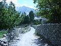 village
 Nabod area of Passu
