Parbhani district
| Parbhani district परभणी जिल्हा | |
|---|---|
| District of Maharashtra | |
 Location of Parbhani district in Maharashtra | |
| Country | India |
| State | Maharashtra |
| Administrative division | Aurangabad division |
| Headquarters | Parbhani |
| Tehsils | 1. Parbhani, 2. Gangakhed, 3. Sonpeth, 4. Pathri, 5. Manwath, 6. Palam, 7. Sailu, 8. Jintur, 9. Purna |
| Government | |
| • Lok Sabha constituencies | 1. Parbhani(shared with Jalna District) based on (Election Commission website) |
| • Assembly seats | 4 |
| Area | |
| • Total | 6,511.58 km2 (2,514.14 sq mi) |
| Population (2011) | |
| • Total | 1,835,982[1] |
| Demographics | |
| • Literacy | 75.22% |
| • Sex ratio | 940 |
| Major highways | NH 222[2] |
| Coordinates | 19°30′N 76°45′E / 19.500°N 76.750°ECoordinates: 19°30′N 76°45′E / 19.500°N 76.750°E |
| Average annual precipitation | June mm |
| Website | Official website |
Parbhani District (formerly also known as Prabhavatinagari), is one of the eight districts in the Marathawada region of Maharashtra state of India. Parbhani city is the headquarters of this district.4Th Largest In Marathwada District. Parbhani district is known for religious tourism. Hazrat Turabul Haq Dargah (108-year-old sufi shrine) and Sri Sai Janmasthan Temple, Pathri (birthplace of Sai Baba of Shirdi) are among important religious places.
History
From 1596 to 1724, major part of the present territory of the district was divided between Pathri and Washim sarkars of Berar Subah of the Mughal empire. In 1724, after the battle of Sakharkheda, it went under the Nizam's rule. Following the re-organization of the states in 1956, Parbhani along with the other districts of Marathwada became part of Bombay State. On May 1, 1960 when Maharashtra state was formed, it became a part of it.[3]
Geography
Parbhani district lies between 18.45 and 20.10 North Latitudes and 76.13 and 77.39 East Longitude. The district is bounded on the north by Hingoli and Buldhana district. On the east by Nanded and Hingoli district, on the South by Latur and on the West by Beed and Jalna districts.
This entire Marathwada region, a district geographical region, was a part of Hyderabad State. After reorganization of states in 1956 it became a part of the then Bombay state and from 1960 onwards it is part of the present Maharashtra state.
The state capital of Mumbai is to the west; Parbhani is well connected by road to other major towns in Maharashtra and also in the neighboring state of Telangana. Parbhani is a major railway junction connecting Telangana with Marathwada. It is also known as a store of Jowar in Marathwada. In the field of education the Parbhani is known for the famous Marathwada agricultural university which is very helpful for the peoples residing all around.
Area and administrative divisions
Parbhani district covers an area of about 6250.58 km2. The district is divided into 9 administrative Sub-units (Tahsils)-Parbhani, Gangakhed, Sonpeth, Pathri, Manwath, Palam, Selu, Jintur, and Purna.
Demographics
According to the 2011 census Parbhani district has a population of 1,835,982,[4] roughly equal to the nation of Kosovo[5] or the US state of Nebraska.[6] This gives it a ranking of 259th in India (out of a total of 640).[4] The district has a population density of 295 inhabitants per square kilometre (760/sq mi) .[4] Its population growth rate over the decade 2001-2011 was 20.18%.[4] Parbhani has a sex ratio of 940 females for every 1000 males,[4] and a literacy rate of 75.22%.[4]
Languages
Languages used in the district include Marathi, Dakhani Urdu, Andh, Hindi, English .[7]
Salient Physical Features
The hills on the north east form part of the Ajanta Hill ranges which passes through Jintur Tahsil. The hills on the southern side are the Balaghat Hill ranges. The district is at an average height of 357 m from mean sea level.
Land of Saints
Parbhani has been described as the land of saints, as several saints have been associated with Parbhani including like Janabai from Gangakhed. The famous mathematician Bhaskarbhatt was from Bori in Parbhani district.
Near Parbhani is the town Selu, where Guru of shri Sai Baba "Shri Babasaheb Maharaj" was living. Sai stayed with him for 12 years during which time he acquired knowledge from his Guru. Shri Sai Baba's birthplace is near Selu, it is Pathari. After some tragedy, Sai Baba came to selu & met Shri Babasaheb Maharaj.
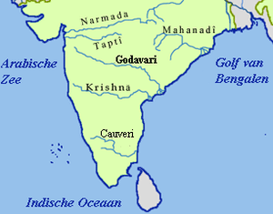
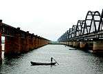
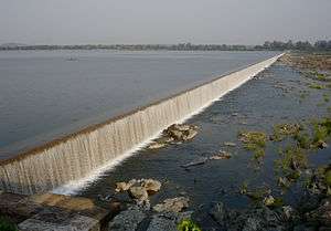
The river Godavari flows through this district. There are so many good temples on the bank of Godavari river and one of them is the Mudgaleshwar Temple at Mudgal, near Parbhani village Dastapur, where great Shri Maroti Maharaj resided who was known as "kirtankar".
Mudgaleshwar
It is located on the bank of the Godavari river. A temple is in the midst of the river. The temple in the middle of the river flow and is more than nine hundred years old and same is written on stone script at the entrance. Temple on river bank and old ghat was built by "Ahilya Bai" 250 years back. Lord "Narasimha Swamy" has taken the form "Shivalinga" along with his wife "Mahalaxmi" and son "Moudgalya" and daughter-in-law "Jaabalabai". During rainy season the temple gets immersed in water. To have darshan one has to swim to the temple. Best time to visit is summer season i.e. from April to June. To reach the place one has to travel by train via "Parbhani" or "Parli Vaidyanath".
The temple used to be managed by Shri Sahebrao Mudgalkar and Shri Subhashrao Mudgalkar. The Shivaratri is celebrated here every year. All type of pujas are performed here. Nagbali and Sukhshanti pujas are very famous.
The new dam is constructed on the river. Recently a Dattatriya temple is constructed and murthy staphana is completed on 26 December 2012.
See also
References
- ↑ "Parbhani District : Census 2011 data". Retrieved 9 October 2012.
- ↑ "NH 222". Wikimapia. Retrieved 12 May 2015.
- ↑ "Chapter 2-History". Parbhani District Gazetteers, Government of Maharashtra. 1967.
- 1 2 3 4 5 6 "District Census 2011". Census2011.co.in. 2011. Retrieved 2011-09-30.
- ↑ US Directorate of Intelligence. "Country Comparison:Population". Retrieved 2011-10-01.
Kosovo 1,825,632 July 2011 est.
- ↑ "2010 Resident Population Data". U. S. Census Bureau. Retrieved 2011-09-30.
Nebraska 1,826,341
- ↑ M. Paul Lewis, ed. (2009). "Andh: A language of India". Ethnologue: Languages of the World (16th ed.). Dallas, Texas: SIL International. Retrieved 2011-09-28.
External links
 |
Jalna district | Buldhana district | Hingoli district | |
| |
Hingoli district | |||
| ||||
| | ||||
| Beed district | Latur district | Nanded district |
| Topics | |||||||||||||||||||||||
|---|---|---|---|---|---|---|---|---|---|---|---|---|---|---|---|---|---|---|---|---|---|---|---|
| Regions | |||||||||||||||||||||||
| Divisions and Districts |
| ||||||||||||||||||||||
| Million-plus cities in Maharashtra | |||||||||||||||||||||||
| Other cities with municipal corporations | |||||||||||||||||||||||
Portal: Maharashtra | |||||||||||||||||||||||
Major Villages of Parbhani district | |
|---|---|
| Parbhani |
|
| Jintur | |
| Gangakhed |
|
| Sailu | |
| Pathri |
|
| Manwath |
|
| Purna |
|
| Sonpeth |
|
| Palam |
|
| |