Pánuco River
| Pánuco River | |
|---|---|
 Panuco River aka Rio de Canoas - Copper-plate engraving from Van Beecq | |
 The Pánuco River is sourced via the Moctezuma and Tula Rivers in the Valley of Mexico | |
| Native name | Río Pánuco |
| Other name(s) | Río de Canoas |
| Country |
|
| States |
Mexico San Luis Potosí Tamaulipas Veracruz |
| Basin | |
| Main source |
Confluence of Moctezuma and Tampaón Rivers 3,800 metres (12,500 ft) 21°58′05″N 98°33′48″W / 21.96806°N 98.56333°W |
| River mouth |
Gulf of Mexico 0 22°16′00″N 97°47′00″W / 22.26667°N 97.78333°WCoordinates: 22°16′00″N 97°47′00″W / 22.26667°N 97.78333°W |
| Alt. difference | 3,800 metres (12,500 ft) |
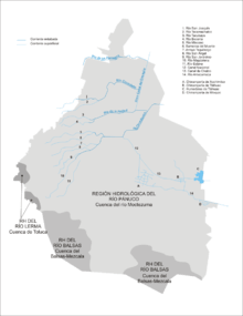
| Basin size | 86,500 square kilometres (33,400 sq mi) |
| Physical characteristics | |
| Length | 120 kilometres (75 mi) |
| Discharge |
|
The Pánuco River (Spanish: Río Pánuco) (Spanish pronunciation: [ˈpanuko]) is a river in Mexico fed by its tributary the Moctezuma River and emptying into the Gulf of Mexico. Since one of the headwaters of the Moctezuma River is the Tula River, the Pánuco ultimately drains the Valley of Mexico containing Mexico City.
Description
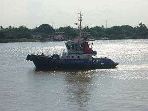
At its source, it serves as a channel for water-drainage for Mexico City. From there, it becomes the state border between Hidalgo and Querétaro as it moves toward San Luis Potosí. It takes the name Río Pánuco upon reaching the state of Veracruz. It empties into the Gulf at Tampico and Ciudad Madero, on the border between the states of Tamaulipas and Veracruz. It is approximately 500 km in length but only the last 15 km is navigable for larger ships.
The Pánuco and its tributaries drain portions of the states of Tamaulipas, San Luis Potosí, Guanajuato, Querétaro, Hidalgo, Mexico, Puebla, and Veracruz.
According to the Atlas of Mexico, the Panuco River is the fourth-largest river in Mexico by volume of runoff, and the sixth-largest river basin in Mexico by area.
Alonso Alvarez de Pineda made a settlement on the river in 1519, later abandoned.[1]:132,309
See also
- Tampico Bridge — crossing the river near its mouth on the Gulf
- List of longest rivers of Mexico
References and external links
- "River Basins", Atlas of Mexico, 1975, with topographical map
- "Panuco", Freshwater Ecoregions of the World
References
- ↑ Diaz, B., 1963, The Conquest of New Spain, London: Penguin Books, ISBN 0140441239