Panola, Sumter County, Alabama
| Panola, Alabama | |
|---|---|
| Census-designated place | |
 Panola, Alabama | |
| Coordinates: 32°57′02″N 88°16′08″W / 32.95056°N 88.26889°WCoordinates: 32°57′02″N 88°16′08″W / 32.95056°N 88.26889°W | |
| Country | United States |
| State | Alabama |
| County | Sumter |
| Area[1] | |
| • Total | 0.719 sq mi (1.86 km2) |
| • Land | 0.718 sq mi (1.86 km2) |
| • Water | 0.001 sq mi (0.003 km2) |
| Elevation | 180 ft (50 m) |
| Population (2010)[2] | |
| • Total | 144 |
| • Density | 200/sq mi (77/km2) |
| Time zone | Central (CST) (UTC−6) |
| • Summer (DST) | CDT (UTC−5) |
| ZIP code | 35477 |
| Area code(s) | 205 |
| GNIS feature ID | 124400[3] |
Panola is an unincorporated community and census-designated place in Sumter County, Alabama, United States. As of the 2010 census, its population was 144. Panola is 6 miles (9.7 km) north-northeast of Geiger. Panola has a post office with ZIP code 35477.[4]
Notable people
- Bill Bruton (1925 – 1995), Major League Baseball center fielder who was the National League stolen base champion in 1953, 1954, and 1955
- Boston Blackie (1943 – 1993), Chicago blues musician
References
- ↑ "US Gazetteer files: 2010, 2000, and 1990". United States Census Bureau. 2011-02-12. Retrieved 2011-04-23.
- ↑ "American FactFinder". United States Census Bureau. Retrieved 2011-05-14.
- ↑ "Panola". Geographic Names Information System. United States Geological Survey.
- ↑ United States Postal Service (2012). "USPS – Look Up a ZIP Code". Retrieved 2012-02-15.
Municipalities and communities of Sumter County, Alabama, United States | ||
|---|---|---|
| Cities | 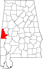 | |
| Towns | ||
| CDPs | ||
| Unincorporated communities | ||
This article is issued from Wikipedia - version of the 11/6/2016. The text is available under the Creative Commons Attribution/Share Alike but additional terms may apply for the media files.