Panguitch, Utah
| Panguitch, Utah | |
|---|---|
| City | |
|
Panguitch Main Street | |
 Location in Garfield County and state of Utah. | |
| Coordinates: 37°49′20″N 112°26′5″W / 37.82222°N 112.43472°WCoordinates: 37°49′20″N 112°26′5″W / 37.82222°N 112.43472°W | |
| Country | United States |
| State | Utah |
| County | Garfield |
| Settled | 1864 |
| Incorporated | June 10, 1899 |
| Named for | Southern Paiute for 'big fish' |
| Government | |
| • Mayor | Eric Houston |
| • Manager | Lori Talbot |
| Area | |
| • Total | 1.4 sq mi (3.5 km2) |
| • Land | 1.4 sq mi (3.5 km2) |
| • Water | 0.0 sq mi (0.0 km2) |
| Elevation | 6,624 ft (2,019 m) |
| Population (2013) | |
| • Total | 1,507 |
| • Density | 1,194.0/sq mi (461.0/km2) |
| Time zone | Mountain (MST) (UTC-7) |
| • Summer (DST) | MDT (UTC-6) |
| ZIP code | 84759 |
| Area code(s) | 435 |
| FIPS code | 49-57740[1] |
| GNIS feature ID | 1444170[2] |

Panguitch /ˈpeɪŋɡwɪtʃ/ is a city in and the county seat of Garfield County, Utah, United States.[3] The population was 1,623 at the 2000 census.
Geography
Panguitch is located at 37°49′20″N 112°26′5″W / 37.82222°N 112.43472°W (37.822234, -112.434650).[4]
According to the United States Census Bureau, the city has a total area of 1.4 square miles (3.5 km²), all of it land.
Climate
| Climate data for Panguitch, Utah (1981–2010) | |||||||||||||
|---|---|---|---|---|---|---|---|---|---|---|---|---|---|
| Month | Jan | Feb | Mar | Apr | May | Jun | Jul | Aug | Sep | Oct | Nov | Dec | Year |
| Average high °F (°C) | 41.0 (5) |
45.2 (7.3) |
53.4 (11.9) |
61.9 (16.6) |
71.4 (21.9) |
82.2 (27.9) |
87.1 (30.6) |
83.9 (28.8) |
77.4 (25.2) |
64.8 (18.2) |
50.6 (10.3) |
40.9 (4.9) |
63.3 (17.4) |
| Average low °F (°C) | 10.2 (−12.1) |
14.6 (−9.7) |
21.2 (−6) |
26.1 (−3.3) |
33.0 (0.6) |
39.7 (4.3) |
46.7 (8.2) |
45.5 (7.5) |
37.0 (2.8) |
26.4 (−3.1) |
17.5 (−8.1) |
10.0 (−12.2) |
27.3 (−2.6) |
| Average precipitation inches (mm) | 0.57 (14.5) |
0.59 (15) |
0.67 (17) |
0.57 (14.5) |
0.64 (16.3) |
0.49 (12.4) |
1.14 (29) |
1.80 (45.7) |
0.98 (24.9) |
1.24 (31.5) |
0.75 (19) |
0.46 (11.7) |
9.90 (251.5) |
| Average snowfall inches (cm) | 5.6 (14.2) |
5.3 (13.5) |
2.1 (5.3) |
0.9 (2.3) |
0.0 (0) |
0.0 (0) |
0.0 (0) |
0.0 (0) |
0.0 (0) |
0.3 (0.8) |
2.4 (6.1) |
2.6 (6.6) |
19.2 (48.8) |
| Source: NOAA[5] | |||||||||||||
History

Panguitch was first settled in March 1864, when Jens Nielsen, a Danish convert to The Church of Jesus Christ of Latter-day Saints (LDS Church), led a group of pioneers eastward from Parowan and Beaver to the Sevier River. Due to the area's high elevation, 6,600 feet above sea level, the settlers' initial crops did not mature and the community suffered severely during the first harsh winter. At a crisis point, seven men left the community to seek flour and foodstuffs from surrounding communities. Heavy snow forced the abandonment of wagons and teams, and the men finished their rescue mission on foot, reportedly by laying one quilt after another upon the snow to maintain their footing.
Due to a conflict with native tribes, the Black Hawk War in Utah, the community was temporarily abandoned in 1867 but was resettled in 1871. Some residents specializing in timber and livestock production were quite successful until economic shifts following World War I. Due to the establishment of Bryce Canyon National Park and the designation of nearby areas as national forests, tourism has since played a major role in the local economy.
Demographics
| Historical population | |||
|---|---|---|---|
| Census | Pop. | %± | |
| 1880 | 846 | — | |
| 1890 | 1,015 | 20.0% | |
| 1900 | 883 | −13.0% | |
| 1910 | 1,338 | 51.5% | |
| 1920 | 1,473 | 10.1% | |
| 1930 | 1,541 | 4.6% | |
| 1940 | 1,979 | 28.4% | |
| 1950 | 1,501 | −24.2% | |
| 1960 | 1,435 | −4.4% | |
| 1970 | 1,318 | −8.2% | |
| 1980 | 1,343 | 1.9% | |
| 1990 | 1,444 | 7.5% | |
| 2000 | 1,623 | 12.4% | |
| 2010 | 1,520 | −6.3% | |
| Est. 2015 | 1,481 | [6] | −2.6% |
As of the census[1] of 2000, there were 1,623 people, 502 households, and 392 families residing in the city. The population density was 1,194.0 people per square mile (460.8/km²). There were 620 housing units at an average density of 456.1 per square mile (176.0/km²). The racial makeup of the city was 94.02% White, 0.49% African American, 2.46% Native American, 0.12% Asian, 2.16% from other races, and 0.74% from two or more races. Hispanic or Latino of any race were 2.90% of the population.
There were 502 households out of which 40.4% had children under the age of 18 living with them, 67.3% were married couples living together, 8.4% had a female householder with no husband present, and 21.9% were non-families. 19.1% of all households were made up of individuals and 11.2% had someone living alone who was 65 years of age or older. The average household size was 3.05 and the average family size was 3.55.
In the city the population was spread out with 32.8% under the age of 18, 8.9% from 18 to 24, 23.2% from 25 to 44, 21.0% from 45 to 64, and 14.1% who were 65 years of age or older. The median age was 32 years. For every 100 females there were 106.8 males. For every 100 females age 18 and over, there were 111.0 males.
The median income for a household in the city was $33,500, and the median income for a family was $39,904. Males had a median income of $28,259 versus $19,375 for females. The per capita income for the city was $12,439. About 6.2% of families and 9.6% of the population were below the poverty line, including 14.8% of those under age 18 and 6.6% of those age 65 or over.
In popular culture
In the science-fiction film Contact (1997), a fictional religious fanatic and suicide bomber named Joseph, played by Jake Busey, filmed his explanation for his death in a hotel in Panguitch, Utah.[8]
See also
References
- 1 2 "American FactFinder". United States Census Bureau. Retrieved 2008-01-31.
- ↑ "US Board on Geographic Names". United States Geological Survey. 2007-10-25. Retrieved 2008-01-31.
- ↑ "Find a County". National Association of Counties. Retrieved 2011-06-07.
- ↑ "US Gazetteer files: 2010, 2000, and 1990". United States Census Bureau. 2011-02-12. Retrieved 2011-04-23.
- ↑ "NOWData - NOAA Online Weather Data". National Oceanic and Atmospheric Administration. Retrieved May 5, 2013.
- ↑ "Annual Estimates of the Resident Population for Incorporated Places: April 1, 2010 to July 1, 2015". Retrieved July 2, 2016.
- ↑ "Census of Population and Housing". Census.gov. Retrieved June 4, 2015.
- ↑ Latter-day Saint (Mormon) and Utah characters and references in the movie Contact (1997) and in the novel Contact, by Carl Sagan
External links
 |
Minersville, Beaver | Circleville | Antimony | |
| Paragonah Parowan |
|
Escalante | ||
| ||||
| | ||||
| Brian Head | Dixie National Forest Hatch |
Bryce Canyon City, Tropic |
Municipalities and communities of Garfield County, Utah, United States | ||
|---|---|---|
| Cities | 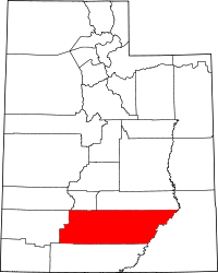 | |
| Towns | ||
| Unincorporated communities | ||
| Ghost towns | ||