Palo Duro Canyon
| Palo Duro Canyon | |
|---|---|
|
View from the Interpretive Center | |
 Palo Duro | |
| Floor elevation | 2,828 ft (862 m) |
| Long-axis length | 70 mi (110 km) |
| Width | 20 mi (32 km) |
| Depth | 880 ft (270 m) |
| Geography | |
| Coordinates | 34°57′N 101°40′W / 34.950°N 101.667°WCoordinates: 34°57′N 101°40′W / 34.950°N 101.667°W |
| Watercourses | Prairie Dog Town Fork Red River |
| Designated | 1976 |

Palo Duro Canyon is a canyon system of the Caprock Escarpment located in the Texas Panhandle near the city of Amarillo, Texas, United States.[1] As the second-largest canyon in the United States, it is roughly 70 mi (110 km) long and has an average width of 6 mi (9.7 km), but reaches a width of 20 mi (32 km) at places. Its depth is around 820 ft (250 m), but in some locations, it can increase up to 1,000 ft (300 m). Palo Duro Canyon (from the Spanish meaning "hard stick")[2] has been named "The Grand Canyon of Texas" both for its size and for its dramatic geological features, including the multicolored layers of rock and steep mesa walls similar to those in the Grand Canyon.
The canyon was formed by the Prairie Dog Town Fork of the Red River, which initially winds along the level surface of the Llano Estacado of West Texas, then suddenly and dramatically runs off the Caprock Escarpment. Water erosion over the millennia has shaped the canyon's geological formations.
Notable canyon formations include caves and hoodoos. One of the best-known and the major signature feature of the canyon is the Lighthouse Rock. A multiple-use, six-mile round trip loop trail is dedicated to the formation. [3]
The painter Georgia O'Keeffe, who lived in nearby Amarillo and Canyon early in the 20th century, wrote of the Palo Duro: "It is a burning, seething cauldron, filled with dramatic light and color."[4]
History
The first evidence of human habitation of the canyon dates back about 10,000–15,000 years, and it is believed to have been continuously inhabited to the present day. Native Americans were attracted to the water of the Prairie Dog Town Fork, Red River, as well as the consequent ample game, edible plants, and protection from weather the canyon provided.
The first European explorers to discover the canyon were members of the Coronado expedition, who visited the canyon in 1541. Apache Indians lived in Palo Duro at the time, but they were later displaced by Comanche and Kiowa tribes, who had the advantage of owning horses brought over by the Spanish. They had contact with traders, called Comancheros, in nearby New Mexico.
A United States military team under Captain Randolph B. Marcy mapped the canyon in 1852 during their search for the headwaters of the Red River. The land remained under American Indian control until a military expedition led by Colonel Ranald S. Mackenzie was sent in 1874 to remove the Indians to reservations in Oklahoma. The Mackenzie expedition captured about 1,200 of the Indians' horses and slaughtered them in nearby Tule Canyon. The Comanche and Kiowa conceded and left the area.
Soon after, in 1876, Charles Goodnight and a wealthy Ulster Scot named John Adair established the JA Ranch in Palo Duro Canyon. Col. Goodnight helped manage the ranch until 1890. Over the next half century, the canyon remained in private hands, but was an increasingly popular tourist spot for local residents.
In 1931, a major landowner signed a two-year contract with the local chamber of commerce to allow public access to the canyon.[5] The upper section of the canyon was purchased by the State of Texas in 1934 and turned into the 20,000-acre (8,100 ha) Palo Duro Canyon State Park. Amarillo is the largest city near Palo Duro Canyon State Park, but the smaller city of Canyon is nearer.
Renovations underway
Through 2014, the Texas Department of Transportation is constructing bridges at Palo Duro over Water Crossings 1, 2, and 6 to allow motorists easier access during and after heavy rains. Paving work has been completed at the Juniper Multi-use Area, with the addition of utilities pending. By the spring of 2014, day-use campsites and a group pavilion will be added. Meanwhile, plans have begun to turn the Canoncita Ranch house located on the canyon edge into a research center.[6]
The old Comanche Trail used by the Civilian Conservation Corps will be restored to extend from the Mack Dick Group Pavilion to Water Crossing 6. The trail will follow the base of Fortress Cliffs. Palo Duro also now offers driving tours in a 12-passenger van for interested sightseers.[6]
 Capitol Peak
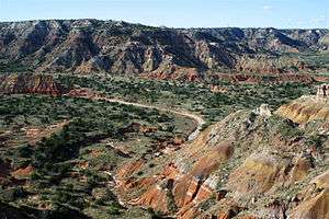 Terrain of Palo Duro
 Landslide at Palo Duro
 The Lighthouse
 Another view of the lighthouse peak
Geology
Palo Duro Canyon was downcut by the Prairie Dog Town Fork tributary of the Red River, during the Pleistocene, when the whole region was uplifted.[7] Most of the strata visible in the Canyon were deposited during the Permian and Triassic periods. From oldest to youngest, the formations are:
- Quartermaster Formation: Permian in age, this comprises the red, lower slopes of the Canyon. This layer was deposited in a shallow marine environment that alternated with dry tidal flats, indicated by ripple marks and gypsum evaporite deposits, respectively.[8]
- Tecovas Formation: Part of the Dockum Group with the Trujillo Formation, this multicolored Triassic unit consists of shale, siltstone, and sandstone. Deposited in streams and swamps, its colors indicate varying oxidizing conditions, and the alternating dry/wet cycles typical of such environments. These rocks are fossiliferous, containing the remains of phytosaurs, amphibians, and fish.[9]
- Trujillo Formation: This Triassic formation is harder than the underlying Tecovas, and forms many of the Canyon's ledges. Composed of coarse sandstone, river cross-bedding indicates deposition in a stream environment. Fossils are rare.[10]
- Ogallala Formation: This late Miocene to early Pliocene unit forms the cliffs and ledges at the very top of the canyon. Composed of sandstone, siltstone, and conglomerate eroded from a late Cenozoic uplift of the Rocky Mountains, it is separated from the lower Trujillo Formation by a disconformity, and a very long hiatus. Fossils of saber-toothed cats (Smilodon), bone-crushing dogs (Borophagines), mastodons, horses, long-necked camels (Aepycamelus), rhinoceroses, and tortoises are present in the Ogallala.[11]
 Windmill at bottom of canyon on the Prairie Dog Town Fork Red River
 Hiking trail to the west of the rancher's dugout in Palo Duro Canyon
 Palo Duro Canyon Interpretive Center built by the Civilian Conservation Corps
 Looking north into the canyon, from the south rim, on Highway 207
 Panoramic view of the Palo Duro Canyon showing the Quartermaster, Tecovas, Trujillo and Ogallala formations
In culture
Palo Duro Canyon is the site of an outdoor historical and musical drama, titled Texas, presented annually each summer by actors, singers, dancers, and artists of the Texas Panhandle region. The spectacle, created by playwright Paul Eliot Green, premiered on July 1, 1966 at the newly constructed Pioneer Amphitheatre in Palo Duro Canyon State Park. It has continued each summer through the present, making Texas "the best-attended outdoor history drama in the nation."[12]
The Symphony No. 3 of American composer Samuel Jones is titled "Palo Duro Canyon." It premiered May 1, 1992 in an outdoor performance at the Palo Duro Canyon State Park's Pioneer Amphitheatre, with James Setapen conducting the Amarillo Symphony (which had commissioned the work). The composer writes: "I wanted the piece ... to conjure up an intuitive awareness of the long movements of time required for the creation of a canyon. I also wanted in some way to pay homage to native Americans, to whom this canyon was a sacred place. And I wanted to capture in music that magical moment which everyone experiences when they first see the flat, treeless High Plains fall dizzyingly away into the colorful vastness of the Palo Duro Canyon itself."[13] A KACV-TV documentary on canyon, composer, and symphony, titled And There Will Be Sounds, was broadcast on PBS stations nationally later that year; and a commercial recording was subsequently released by the Seattle Symphony under the baton of Gerard Schwarz.[14]
See also
References
- ↑ TPWD: Palo Duro Canyon
- ↑ Palo Duro Canyon State Park web site
- ↑ "Logan G. Carver, "Palo Duro Canyon quick getaway from Lubbock"". Lubbock Avalanche-Journal. Retrieved June 21, 2009.
- ↑ Georgia O'Keeffe exhibit, Panhandle-Plains Historical Museum, Canyon, Texas
- ↑ Steely, James Wright. Parks for Texas: Enduring Landscapes of the New Deal. Austin: U of Texas, 1999. Print.
- 1 2 Kevin Welch, "Palo Duro Canyon plans improvements", July 23, 2013, lubbockonline.com, retrieved July 24, 2013
- ↑ Spearing, Darwin. Roadside Geology of Texas. Missoula: Mountain Press Publishing Co., 1991. ISBN 0-87842-265-X p. 381
- ↑ Spearing, pp. 377, 383
- ↑ Spearing, 384-5
- ↑ Spearing, pp. 384-5
- ↑ Spearing, pp. 355-6, 385
- ↑ The Texas Observer; Austin, Texas; July 13, 2015. Reinventing Texas, by Robyn Ross. Retrieved September 24, 2015.
- ↑ Jones, Samuel. Notes to Symphony No. 3 ("Palo Duro Canyon"). Retrieved September 25, 2015.
- ↑ Schwarz, Gerard (conductor); Seattle Symphony. Jones: Symphony No. 3 "Palo Duro Canyon," Concerto for Tuba and Orchestra. Naxos 8.559378, 2009.
External links
| Wikimedia Commons has media related to Palo Duro Canyon State Park. |
| Wikivoyage has a travel guide for Palo Duro Canyon. |
- Palo Duro Canyon State Park official website
- Texas Parks and Wildlife: Palo Duro Canyon
- Read Exploration of the Red River, by Randolph Marcy, 1852, hosted by the Portal to Texas History.
- Handbook of Texas Online: Palo Duro Canyon
- Permo-Triassic Redbeds
- U.S. Geological Survey Geographic Names Information System: Palo Duro State Park
- Public domain photos of the Llano Estacado