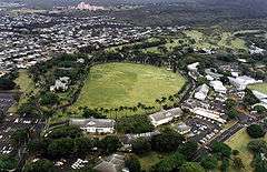
Palm Circle
|
Palm Circle Historic District | |
 | |
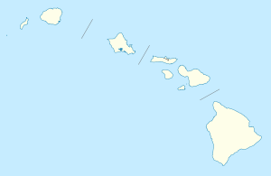 | |
| Location | Roughly bounded by Carter Dr., Richardson and Funston Rds., A and B Sts., Honolulu, Hawaii |
|---|---|
| Coordinates | 21°21′0″N 157°53′25″W / 21.35000°N 157.89028°WCoordinates: 21°21′0″N 157°53′25″W / 21.35000°N 157.89028°W |
| Area | 32 acres (13 ha) |
| Built | 1907 |
| Architect | Quartermaster Corps |
| NRHP Reference # | 84000104[1] |
| Significant dates | |
| Added to NRHP | October 26, 1984[1] |
| Designated NHLD | May 28, 1987[2] |
Palm Circle or the Pineapple Pentagon,[2] is the portion of Fort Shafter in Honolulu, Hawaii which housed the headquarters of the commanding general and his staff, U.S. Army forces, Pacific Ocean Areas, during World War II. By 1944 this command was responsible for the supply and administration of all U.S. Army personnel in the Central and South Pacific, and from 1943 to 1945, carried out logistical planning for the invasions of the Gilberts, Marshalls, Marianas, Guam, Palau, and Okinawa.[3][4]
References
- 1 2 National Park Service (2010-07-09). "National Register Information System". National Register of Historic Places. National Park Service.
- 1 2 "Palm Circle". National Historic Landmark summary listing. National Park Service. Retrieved 2008-07-04.
- ↑ Thompson, Erwin N. (June 13, 1986). "Palm Circle, 100 Area, Fort Shafter" (pdf). National Register of Historic Places - Nomination and Inventory. National Park Service. Retrieved 25 May 2012.
- ↑ "Palm Circle, 100 Area, Fort Shafter" (pdf). Photographs. National Park Service. Retrieved 25 May 2012.
| Topics | |
|---|---|
| Lists by states |
|
| Lists by insular areas | |
| Lists by associated states | |
| Other areas | |
| |
This article is issued from Wikipedia - version of the 11/26/2016. The text is available under the Creative Commons Attribution/Share Alike but additional terms may apply for the media files.