Paleocurrent
A paleocurrent or paleocurrent indicator is a geological feature (typically a sedimentary structure) that helps one determine the direction of flowing water in the geologic past. This is an invaluable tool in the reconstruction of ancient depositional environments.[1]
There are two main types of paleocurrent indicators:
- Unidirectional, which give a clear, single direction of flow
- Bidirectional, which give a good linear direction, but it is unclear which direction along the linear trend the water flowed.
Paleocurrents are usually measured with an azimuth, or as a rake on a bedding plane, and displayed with a Rose Diagram to show the dominant direction(s) of flow. This is needed because in some depositional environments, like meandering rivers, the paleocurrent resulting from natural sinuosity has a natural variation of 180 degrees or more.[2]
Below are a partial list of common paleocurrent indicators:
Unidirectional

Flute cast, showing paleocurrent to the upper right of pic
- Cross-bedding - the axis of a trough cross bed or the down-dip direction of a tabular cross bed point the direction of paleo flow.
- Current ripple marks - will have the short side of the ripple pointing down stream.
- Sole markings/flute casts - the short, steep side will point up stream, and the long, tapered side points down stream.
- Imbrication - clasts line up in the direction of flow.
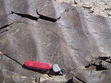
Bidirectional

Parting lineation, from lower right to upper left; Kayenta Formation, Canyonlands National Park.
- Symmetrical ripple marks - flow is perpendicular to the ridge crest.
- Tool mark - flow is along the mark.
- Parting lineations - flow is along the grains.
References
| The Wikibook Historical Geology has a page on the topic of: Paleocurrents |
- ↑ Prothero, D. R. and Schwab, F., 1996, Sedimentary Geology, pg. 48-51, ISBN 0-7167-2726-9
- ↑ Miaoa, Xiaodong; Huayu Lua; Zhen Lid; Guangchao Caod (July 2008). "Paleocurrent and fabric analyses of the imbricated fluvial gravel deposits in Huangshui Valley, the northeastern Tibetan Plateau, China". Geomorphology. © 2007 Elsevier B.V. 99 (1-4): 433–442. Bibcode:2008Geomo..99..433M. doi:10.1016/j.geomorph.2007.12.005.
This article is issued from Wikipedia - version of the 4/13/2016. The text is available under the Creative Commons Attribution/Share Alike but additional terms may apply for the media files.