Paleic surface
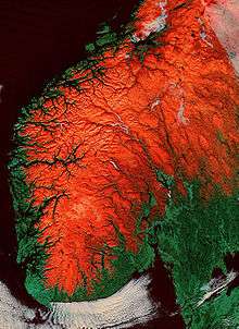
The paleic surface or palaeic surface (Norwegian: paleisk overflate, from Ancient Greek palaios, meaning "old"[1]) is an erosion surface of gentle slopes that exist in South Norway.[2] Parts of it are considered a continuation of the Sub-Cambrian peneplain found further east.[3] The peneplain surfaces of the paleic surface are apparently disrupted by vertical displacement along faults, following an NNE-SSW orientation.[3] In south-western Norway the Paleic surface is strongly dissected by valleys and fjords.[4]
The lower levels the Paleic surface are thought to have been formed by the following key processes: etching, stripping and pediplanation. The climate under which these processes occurred was likely warm relative to the present.[5] To the north the lower levels of the Paleic surface is considered to be equivalent to the Muddus plains in northern Sweden, meaningthat topography is likely to have developed at the same time and level, and by the same processes.[5]
The paleic surface has reached its elevated position in a process related to the opening of the Atlantic Ocean that begun 140 millions years ago.[1]
The concept of a paleic surface was first introduced by Hans Reusch in 1901.[6]
See also
References
- 1 2 Lidmar-Bergström, Karna. "Paleiska ytan". Nationalencyklopedin (in Swedish). Cydonia Development. Retrieved June 22, 2015.
- ↑ Bryhni, Inge. "paleisk overflate". Store norske leksikon (in Norwegian). Kunnskapsforlaget. Retrieved June 22, 2015.
- 1 2 Jarsve, Erlend M.; Krøgli, Svein Olav; Etzelmüller, Bernd; Gabrielsen, Roy H. (2014). "Automatic identification of topographic surfaces related to the sub-Cambrian peneplain (SCP) in southern Norway—Surface generation algorithms and implications". Geomorphology. Elsevier. 211: 89–99.
- ↑ Corner, Geoffrey (2004). "Scandes Mountains". In Seppälä, Matti. The Physical Geography of Fennoscandia. Oxford University Press. p. 240–254. ISBN 0-19-924590-8.
- 1 2 Lidmar-Bergström, K.; Näslund, J.O. (2002). "Landforms and uplift in Scandinavia". In Doré, A.G.; Cartwright, J.A.; Stoker, M.S.; Turner, J.P.; White, N. Exhumation of the North Atlantic Margin: Timing, Mechanisms and Implications for Petroleum Exploration. Geological Society, London, Special Publications. The Geological Societ y of London. p. 103–116.
- ↑ Green, Paul F.; Lidmar-Bergström, Karna; Japsen, Peter; Bonow, Johan M.; Chalmers, James A. (2013). "Stratigraphic landscape analysis, thermochronology and the episodic development of elevated, passive continental margins". Geological Survey of Denmark and Greenland Bulletin. 30: 18. Retrieved 30 April 2015.