Pacoima Dam
| Pacoima Dam | |
|---|---|
|
The Pacoima Dam, viewed from Contract Point. | |
| Country | United States |
| Location | Los Angeles County, California |
| Coordinates | 34°20′05″N 118°23′47″W / 34.33472°N 118.39639°WCoordinates: 34°20′05″N 118°23′47″W / 34.33472°N 118.39639°W |
| Status | In use |
| Construction began | 1925 |
| Opening date | 1928 |
| Owner(s) | Los Angeles County Department of Public Works |
| Dam and spillways | |
| Type of dam | arch |
| Impounds | Pacoima Creek |
| Height | 371 feet (113 m) |
| Length | 640 feet (200 m) |
| Spillways | 1 |
| Spillway type | Service, concrete tunnel |
| Spillway capacity | 24,700 cubic feet per second (700 m3/s) |
| Reservoir | |
| Creates | Pacoima Reservoir |
| Total capacity | 3,777 acre feet (4,659,000 m3) |
| Catchment area | 27.8 square miles (72 km2) |
| Surface area | 68 acres (28 ha) |
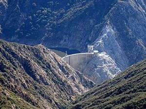
Pacoima Dam is a concrete arch dam on Pacoima Creek in the San Gabriel Mountains, in Los Angeles County, California. The reservoir which it creates, Pacoima Reservoir, has a capacity of 3,777 acre feet (4,659,000 m3)[1]
Built by the Los Angeles County Flood Control District, which became part of the Department of Public Works, it was completed in 1928. At the time, the 371 foot (113m) high dam was the tallest arch dam in the U.S.[1]
The dam is situated approximately 5 miles (8.0 km) northeast of Sylmar, above the San Fernando Valley.[1]
Instrumentation
As construction of Pacoima Dam began, the County of Los Angeles hired Roy W. Carlson[2] as their concrete and soil testing engineer. He developed the world’s first strain meter which could be embedded in concrete. He also developed an adiabatic calorimeter and electrical-resistance thermometers to determine why the temperature of concrete increased during curing and how best to avoid cracking caused by these stresses.[3]
Earthquake monitoring
The Pacoima Dam withstood, but was damaged by the very strong ( >1 g ) ground movement which occurred during both the 1971 and 1994 earthquakes. Because of concerns about the stability of the dam and especially its response to potential future earthquakes, the County of Los Angeles, with the technical support of the USGS, began monitoring the dam using continuous GPS.[1]
See also
References
- 1 2 3 4 Hudnut, Kenneth W. & Behr, Jeffrey A. (1998). "Continuous GPS monitoring of Structural Deformation at Pacoima Dam, California". Seismological Society of America. Retrieved 2014-01-23.
- ↑ Electrical Engineering and Computer Sciences, UC Berkeley "Dr. Roy W. Carlson"
- ↑ Rogers, J. David (2012). "DAMS AND DISASTERS: a brief overview of dam building triumphs and tragedies in California's past" (PDF). University of California Davis. Retrieved 2014-01-23.
Dams in Los Angeles County, California | ||
|---|---|---|
| CA Department of Water Resources |  | |
| LA Department of Public Works |
| |
| LA Department of Water and Power |
| |
| US Army Corps of Engineers | ||
| Other |
| |