Pachalum
| Pachalum | |
|---|---|
| Municipality | |
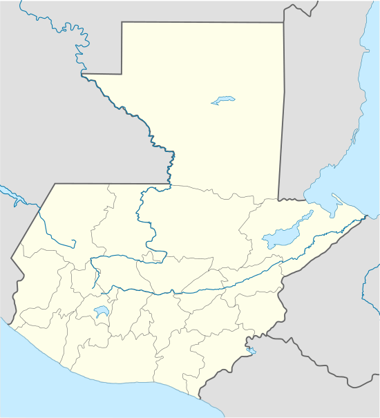 Pachalum Location in Guatemala | |
| Coordinates: 14°55′37″N 90°39′54″W / 14.92694°N 90.66500°WCoordinates: 14°55′37″N 90°39′54″W / 14.92694°N 90.66500°W | |
| Country |
|
| Department |
|
| Municipality | Pachalúm |
| Government | |
| • Type | Municipal |
| Area | |
| • Municipality | 100 km2 (40 sq mi) |
| Population (Census 2002) | |
| • Municipality | 7,037 |
| • Urban | 2,042 |
| • Ethnicities | K'iche', Ladino |
| • Religions | Roman Catholicism, Evangelicalism, Maya |
| Climate | Aw |
Pachalúm is a municipality in the Guatemalan department of El Quiché.
Pachalúm had been a village in the municipality of Joyabaj, but was recognized as separate municipality in 1986.[1]
History
The name «Pachalum» originated from the Pachecas' game which men practiced under the shadow of a "Chalum" tree during the early years of the 20th century.[2]
During the Spanish colony
José de Alvarado —relative of conquistador Pedro de Alvarado— was given from the Kingdom of Guatemala authorities more than one hundred fift acress of land in the Santa María Xoyavaj region, dando origen a los establecimientos de colonizadores españoles en la región. Pachalúm was mentioned for the first time in 1817, as place for sugar production settled by Spanish families that arrived there from San Martín Jilotepeque, Santa Cruz El Chol and from most of the modern Baja Verapaz Department.[2]
After Independence from Spain
After the revolution against field marshal Vicente Cerna y Cerna in 1871, the families of the revolutionary leaders that helped the Liberal revolt asked Joyabaj mayor that their settlement became a village, which was granted on 9 August 1872.[3]
Administrative division
The municipality has an area of 100 km; besides the municipal capital, there are eight villages, thirteen settlements and five farm fields.[2][3]
| Division | Name | Settelements |
|---|---|---|
| Villages | Las Moritas | El Naranjito |
| Los Altos | Piedras Blancas | |
| El Cimarrón | Caseríos Toro Seco, Las Minas y San José El Jute | |
| El Ciprés | Ciprés Segundo Centro | |
| Llano Grande | San Vicente | |
| Agua Zarca | Tamarindo y Trapichitos | |
| Volcancillos | Veguitas de Mercedes, Guachipilín, El Anono y Tablones | |
| Las Vegas | N/A | |
| Farm fields | La Laguna Seca | |
| San Isidro | ||
| El Maguey | ||
| San Miguel | ||
| Incienso | ||
Topography
Pachalúm is located in Sierra de Chuacús, specifically at the bottom of Tuncaj Hill, where several sprinkles come down. It is also close to the Motagua river basin, cuyos afluentes, los ríos Las Vegas y Tumbadero, humedecen el terreno de la localidad.[3]
Municipal government and infrastructure
The first elections ever held in Pachalúm resulted in victory of Vicente de la Roca in 1986, but his term was not that effective due to the lack of experience on managing a municipality; the next mayor was Rafael Elías who focused on the area development. Afterwards, teach Reynabel Estrada Roca was elected, serving for three terms.[2]
Among those projects finished during Estrada Roca's term in office are:
- paved road between Pachalúm and Guatemala City, via Concuán
- Grocery market building
- Municipal Hotel
- Sports complex
- Urban area pavement
- irrigation project, led by Hugo Lorenzo Duarte Estrada[3]
Other important access roads to Pachalúm are:
- Pachalúm -Chimaltenango, via San Martín Jilotepeque, 70% paved
- Pachalum - Santa Cruz del Quiché, 92 km long, with 16 km unpaved
- Pachalum - Cubulco, 20 km long[2]
Climate
Pachalúm has a tropical savanna climate (Köppen: Aw).
| Climate data for Pachalúm | |||||||||||||
|---|---|---|---|---|---|---|---|---|---|---|---|---|---|
| Month | Jan | Feb | Mar | Apr | May | Jun | Jul | Aug | Sep | Oct | Nov | Dec | Year |
| Average high °C (°F) | 26.5 (79.7) |
27.3 (81.1) |
28.8 (83.8) |
28.9 (84) |
28.7 (83.7) |
27.4 (81.3) |
27.3 (81.1) |
27.4 (81.3) |
26.8 (80.2) |
26.5 (79.7) |
26.4 (79.5) |
26.3 (79.3) |
27.36 (81.23) |
| Daily mean °C (°F) | 20.0 (68) |
20.1 (68.2) |
21.8 (71.2) |
22.4 (72.3) |
22.7 (72.9) |
22.3 (72.1) |
22.1 (71.8) |
21.9 (71.4) |
21.6 (70.9) |
21.2 (70.2) |
20.4 (68.7) |
19.7 (67.5) |
21.35 (70.43) |
| Average low °C (°F) | 13.5 (56.3) |
13.6 (56.5) |
14.9 (58.8) |
16.0 (60.8) |
16.7 (62.1) |
17.3 (63.1) |
17.0 (62.6) |
16.5 (61.7) |
16.4 (61.5) |
15.9 (60.6) |
14.5 (58.1) |
13.2 (55.8) |
15.46 (59.83) |
| Average precipitation mm (inches) | 3 (0.12) |
7 (0.28) |
12 (0.47) |
35 (1.38) |
111 (4.37) |
247 (9.72) |
168 (6.61) |
127 (5) |
208 (8.19) |
121 (4.76) |
28 (1.1) |
5 (0.2) |
1,072 (42.2) |
| Source: Climate-Data.org[5] | |||||||||||||
Geographic location
 |
Joyabaj, El Quiché Department municipality | Baja Verapaz Department | | |
| |
Baja Verapaz Department[4] | |||
| ||||
| | ||||
| Chimaltenango Department | Guatemala Department[4] |
See also
-
 Guatemala portal
 -
 Geography portal
 - El Quiché Department
Notes and references
References
- ↑ Acuerdo Gubernativo 377-86 of the 27th of June 1986, mentioned in http://pachalum.pa.funpic.org/
- 1 2 3 4 5 "Historia de Pachalúm". Municipalidad de Pachalúm. Guatemala. 2009. Archived from the original on May 24, 2009. Retrieved 9 November 2009.
- 1 2 3 4 Barrios Gramajo, Mario Jobel (n.d.). "Historia de Pachalum". Municipalidad de Pachalum. Guatemala. Retrieved 21 January 2016.
- 1 2 3 SEGEPLAN (n.d.). "Municipios de Quiché, Guatemala". Secretaría General de Planificación y Programación de la Presidencia de la República (in Spanish). Guatemala. Archived from the original on 2 July 2015. Retrieved 30 June 2015.
- ↑ "Climate: Pachalúm". Climate-Data.org. Retrieved 22 January 2016.
External links
Capital: Santa Cruz del Quiché | ||
| Municipalities |  | |