Pennsylvania Route 430
| ||||
|---|---|---|---|---|
 | ||||
| Route information | ||||
| Maintained by PennDOT | ||||
| Length: | 13.703 mi[1] (22.053 km) | |||
| Existed: | 1959 – present | |||
| Major junctions | ||||
| West end: |
| |||
|
| ||||
| East end: |
| |||
| Location | ||||
| Counties: | Erie | |||
| Highway system | ||||
| ||||

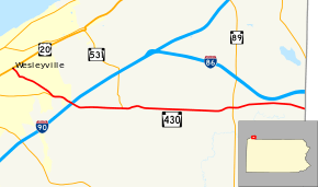
Pennsylvania Route 430 (also known by the Pennsylvania Department of Transportation as SR 0430) is a 13.70-mile-long (22.05 km) state highway located in Erie County, Pennsylvania. The western terminus is at US 20 in Wesleyville. The eastern terminus is the New York state line near Findley Lake, New York.
Route description

PA 430 begins at an intersection with US 20 (Buffalo Road) in the borough of Wesleyville just south of the railroad tracks through the borough. PA 430 proceeds southeast along Station Road, a two-lane residential street through Wesleyville, running several blocks through the borough. At the junction with Euclid Boulevard, PA 430 and Station Road turn eastward while the right-of-way becomes Shannon Road. Becoming a commercial street through the eastern parts of the borough, soon crossing into Harborcreek Township. Crossing southeast through the township, PA 430 returns to a two-lane residential road, entering the Brookside neighborhood.[2]
Through Brookside, PA 430 remains a two-lane residential street, soon leaving the community for another portion of Harborcreek Township. The route then intersects and merges with PA 290 (the Bayfront Connector). PA 290 and PA 430 become concurrent eastward along the four-lane arterial. Station Road becomes a frontage road for the Connector, which soon turns southeast into an interchange with exit 32 of I-90. At this interchange, PA 290 ends and PA 430 continues southeast along Station Road as the Bayfront Connector ends. Still in Harborcreek Township, PA 430 bends eastward as a two-lane residential road, which slowly becomes a two-lane rural roadway. The route then enters the village of Owens Corners, where it intersects with the southern terminus of PA 531 (Depot Road).[2]

Continuing east from PA 531, PA 430 climbs some local hills and becomes more rural as it climbs through Harbocreek Township. Crossing into Greenfield Township, the route becomes more residential as it runs down the hill, retaining the Station Road moniker. The route becomes more rural again as the route enters the village of Hornby, soon crossing the southern end of Greenfield Community Park. PA 430 runs along a curve to the northeast and immediately turns east into an intersection with PA 89. After PA 89, PA 430 turns northeast further through another hill in Greenfield Township Now a more rural highway, the route parallels to the south of I-86, where it turns southeast to the New York state line, marking the eastern end of PA 430. The route continues east along Station Road on New York State Route 430 (NY 430).[2]
History
State Route 430 was assigned to a previously unnumbered roadway[3] in Erie County in 1959.[4] The route was assigned as a continuation of New York State Route 430 (assigned by 1935 in NY[5]), which had been extended from Mayville.[6] The two designations have remained the same since.[7]
Major intersections
The entire route is in Erie County.
| Location | mi[1] | km | Destinations | Notes | |
|---|---|---|---|---|---|
| Wesleyville | 0.000 | 0.000 | |||
| Harborcreek Township | 2.191 | 3.526 | Western terminus of concurrency with PA 290. | ||
| 3.155 | 5.077 | Exit 32 (I-90). | |||
| 3.452 | 5.555 | Eastern terminus of PA 290. | |||
| 5.465 | 8.795 | Southern terminus of PA 531. | |||
| Greenfield Township | 10.437 | 16.797 | |||
| 13.703 | 22.053 | Continuation into New York. | |||
1.000 mi = 1.609 km; 1.000 km = 0.621 mi
| |||||
See also
 U.S. Roads portal
 Pennsylvania portal
References
- 1 2 Bureau of Maintenance and Operations (January 2015). Roadway Management System Straight Line Diagrams (Report) (2015 ed.). Pennsylvania Department of Transportation. Retrieved June 30, 2015.
- Erie County (PDF)
- 1 2 3 Microsoft; Nokia (March 6, 2013). "overview map of PA 430" (Map). Bing Maps. Microsoft. Retrieved March 6, 2013.
- ↑ Erie County, Pennsylvania (Map) (3 ed.). Cartography by Pennsylvania Department of Highways. Pennsylvania Department of Highways. 1954.
- ↑ Pennsylvania Official Highway Map (Map) (3 ed.). Cartography by Pennsylvania Department of Highways. Pennsylvania Department of Highways. 1959.
- ↑ Road Map & Historical Guide - New York (Map). Cartography by Rand McNally and Company. Sun Oil Company. 1935.
- ↑ New York (Map). Cartography by Rand McNally and Company. Sunoco. 1952.
- ↑ Pennsylvania - Official State Map (Map). Pennsylvania Department of Transportation. 2008.
External links
| Wikimedia Commons has media related to Pennsylvania Route 430. |